What Makes North Richmond a Hotspot?

The North Richmond shoreline and its people and ecosystems are highly vulnerable to the impacts of sea level rise exacerbated by environmental injustice by polluting industries. Due to contaminated soil near the shoreline, rising water levels are putting wildlife and communities at risk.

Quick Data

TOTAL Population: 3,928

Population by Race

Cost Burdened Renters

History

TIME IMMEMORIAL

The region known as North Richmond was originally inhabited by the Ohlone people as far back as 4000 B.C.E.

1848–1850

Thousands of gold seekers traveled to the Bay Area during the Gold Rush, ballooning the region’s population and contaminating the San Pablo Bay with large amounts of sediment, mercury, and cyanide. 

1907

North Richmond was established as a company town by the California Wine Association (CWA) to provide housing for wine workers.

1939–1945

During World War II, African Americans migrated from the South to work in local wartime industries like Richmond’s Kaiser Shipyards. Due to exclusionary practices by the City of Richmond, North Richmond was one of the few communities Black Americans were allowed to live in.

LATE 1960s

North Richmond became a focal point of civil rights activism and community organizing efforts, with groups like the Black Panther Party and the United Front advocating for social change.

1992

Chevron completed restoration of Wildcat Marsh without protecting the area’s marshlands or baylands from future development.

2003

The Chevron Flaring incident caused 26 people to seek medical attention.

2008

Communities for a Better Environment (CBE) and partners fought to stop Chevron from expanding their refinery operations in Richmond.

2012

The Chevron Crude Oil Unit Fire caused 15,000 Richmond residents and workers to seek medical attention.

2018

Resilient by Design brought together community-based organizations, elected officials, and residents to rethink the relationship to the shoreline.

2022

Urban Tilth, Sierra Club, and other partners organized against another proposed industrial development that would threaten the health of an adjacent farm and exacerbate the community’s public health risk. The County agreed to various policies to curb the impacts, but with the surrounding area still zoned as light industrial, more development will likely be on the way. 

PHOTO BY LOREM IPSUM

Climate Vulnerabilities

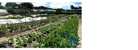
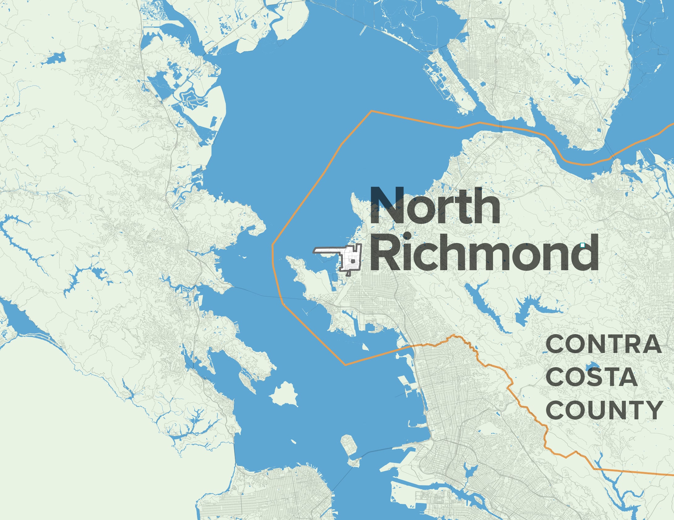
Legacies of land-use discrimination, a confluence of geographic features, and a high share of residents experiencing housing and economic insecurity put North Richmond at risk of devastating impacts from climate change if no action is taken.

Inland Flooding & Sea Level Rise

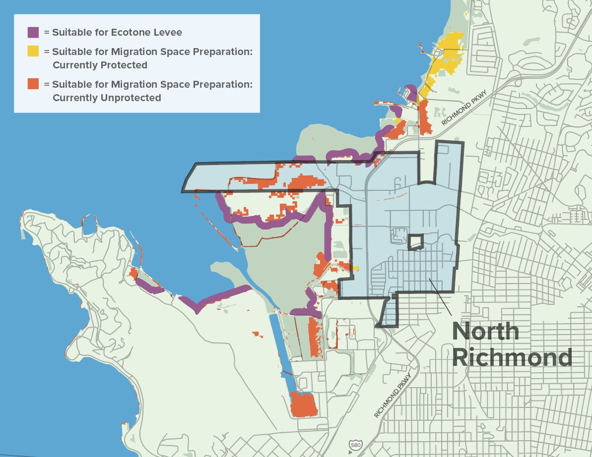
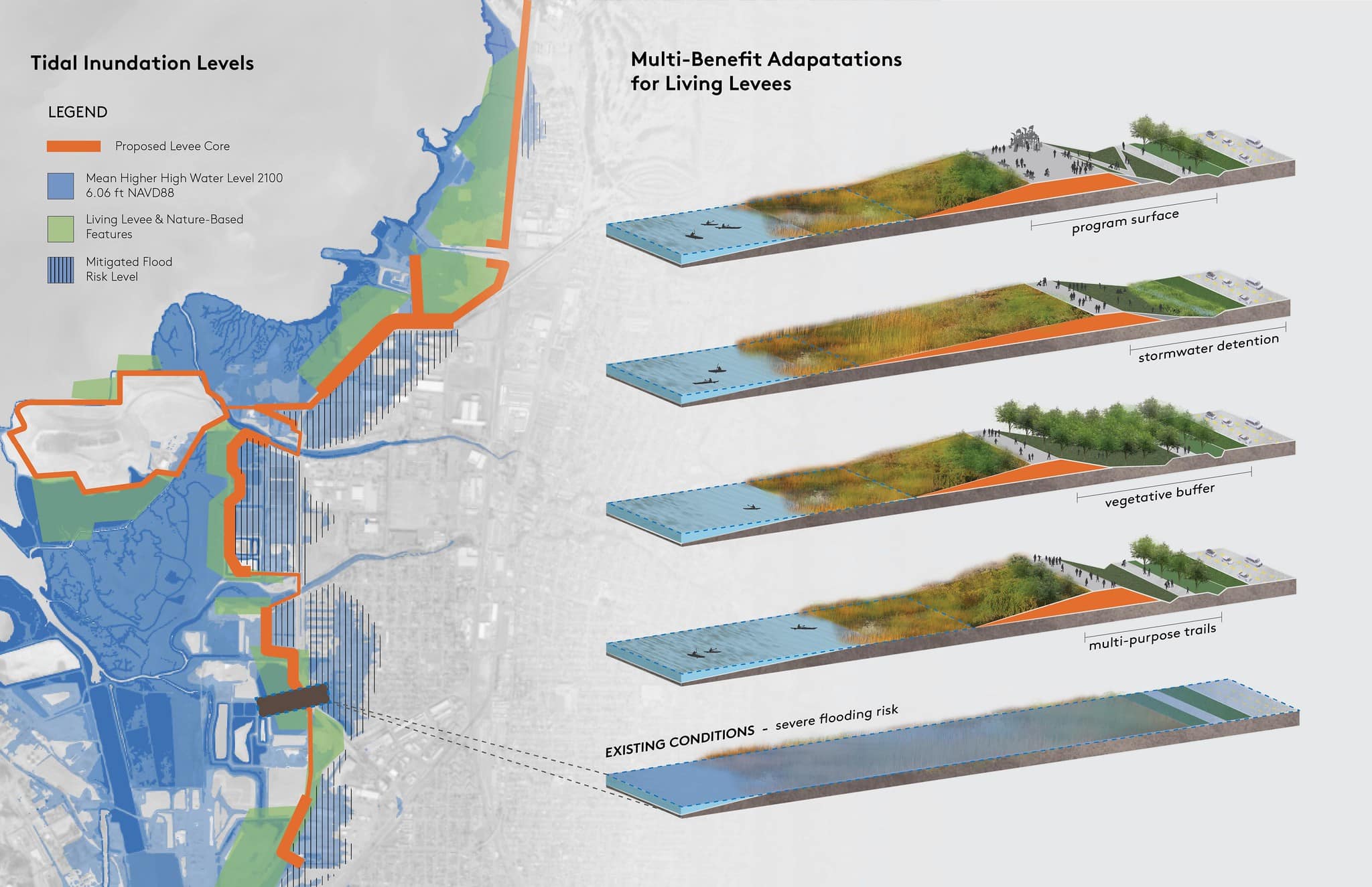
North Richmond is poised to experience flooding of Wildcat Marsh by 2030 with more severe impacts to shoreline assets, coastal ecosystems, and communities with 36 inches of sea level rise, which could be a reality as early as 2050.

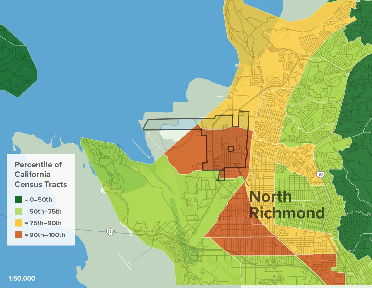
Sea Level Rise in North Richmond
0
108

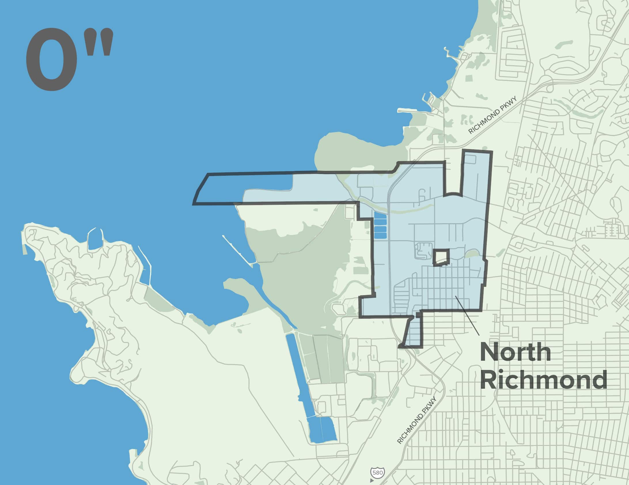
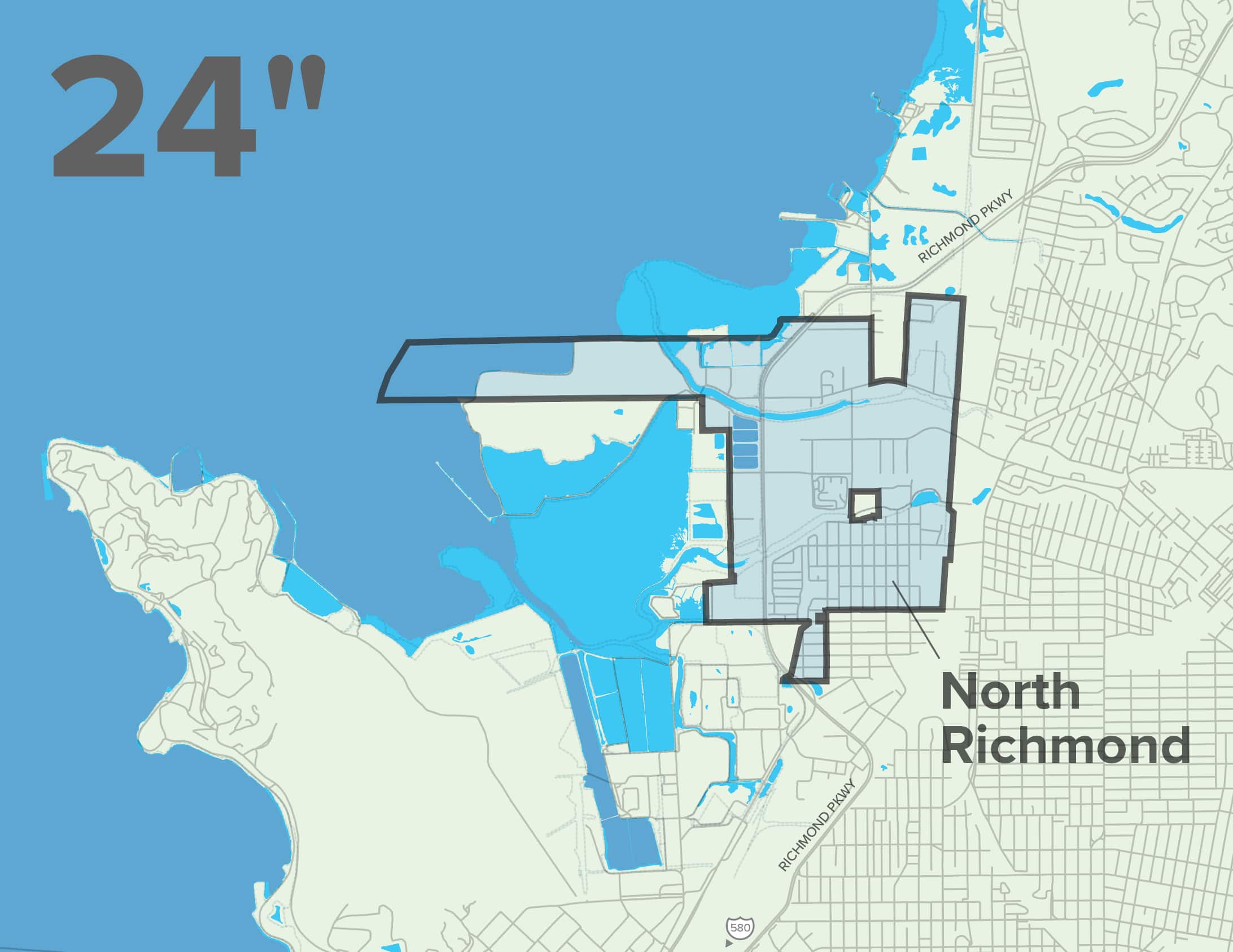
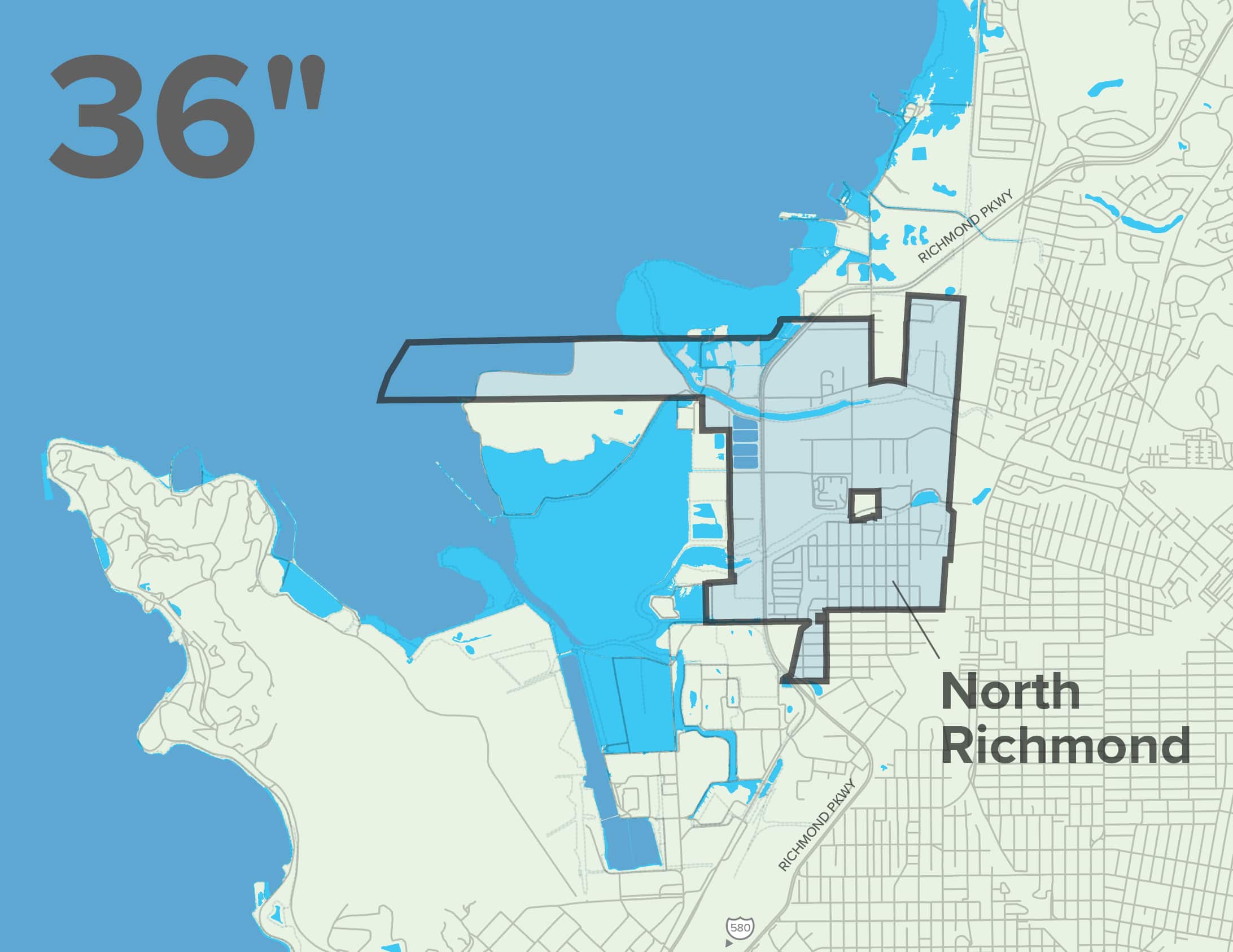
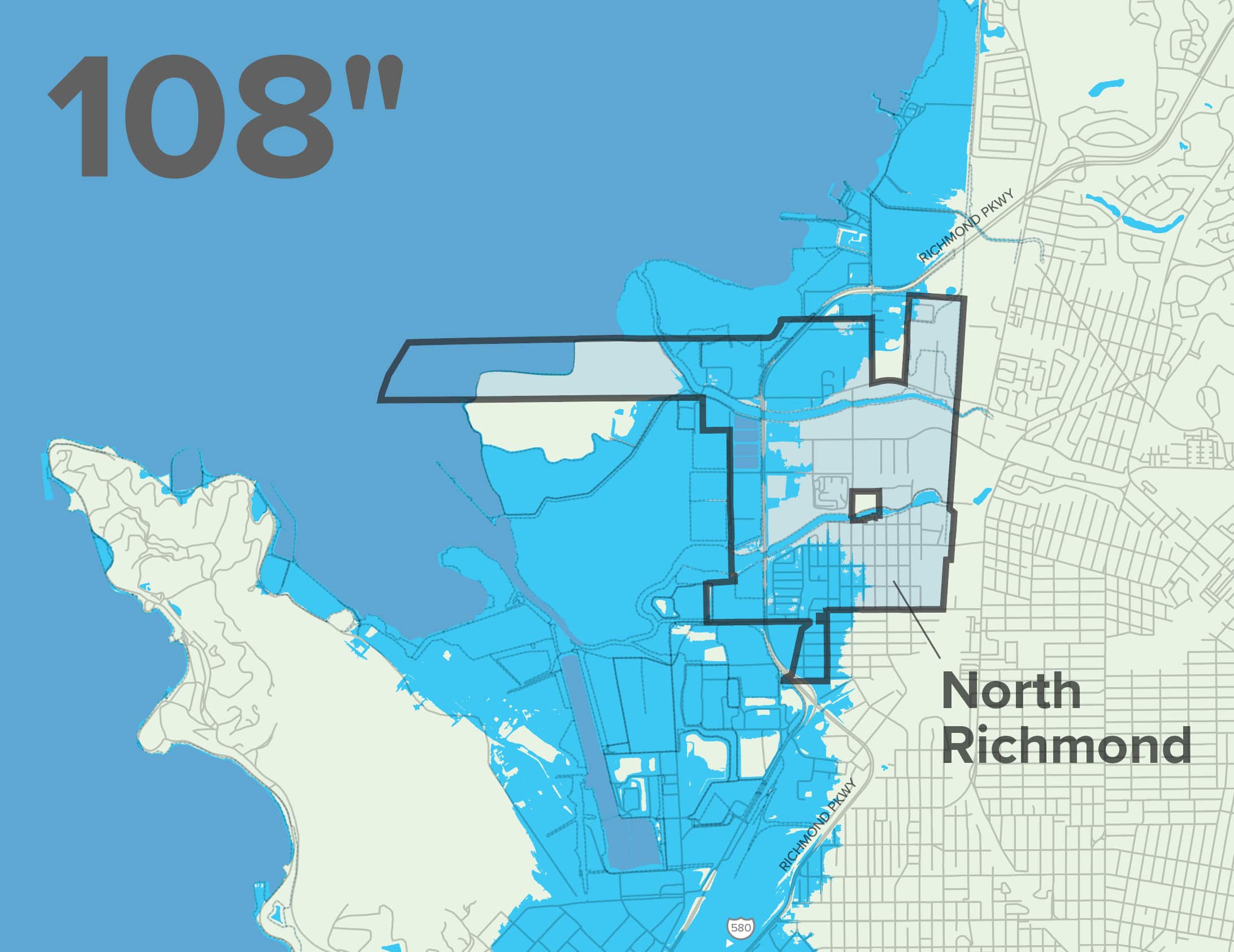
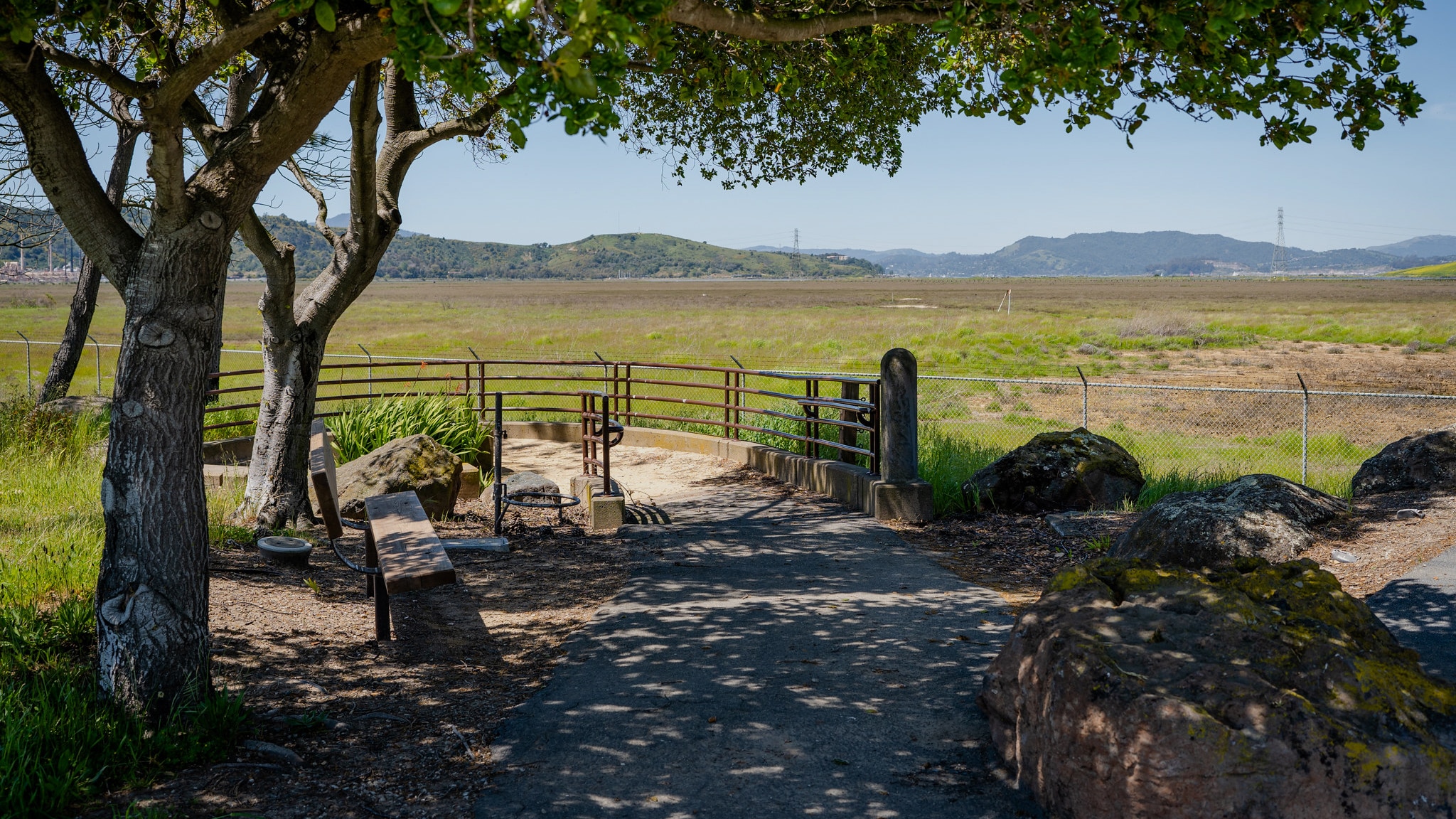
North Richmond’s low lying geography and proximity to Wildcat Creek and the bayshore make it a bowl for collecting water and therefore extremely vulnerable to overtopping and flooding.

Acute rainfall events have offered a glimpse into the severe impacts that are to come. Sea level rise will further exacerbate flooding by first causing damage to bayside marshlands that act as the first line of defense.

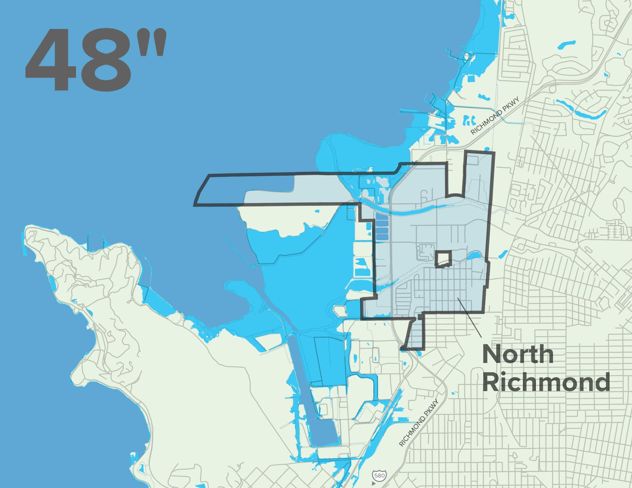
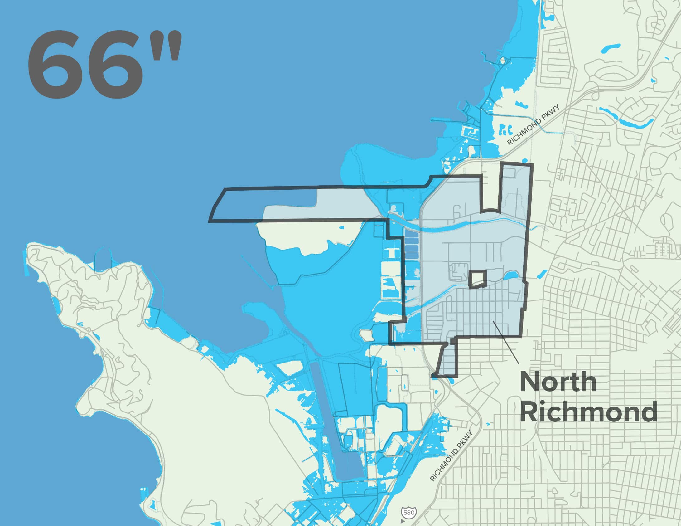
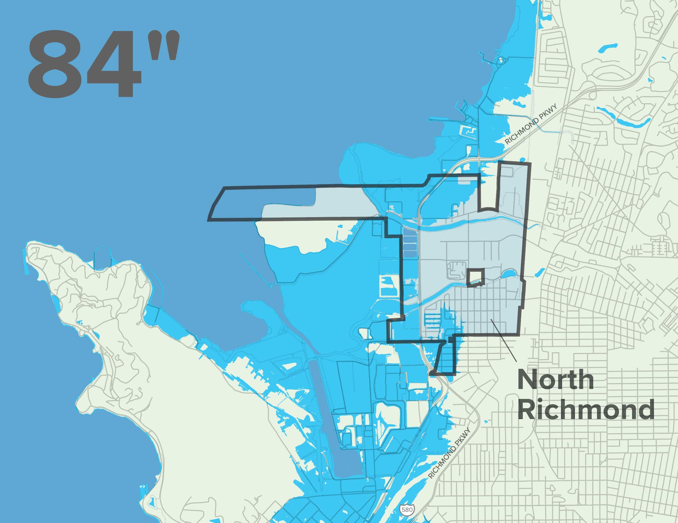
Shoreline infrastructure and industry on the westside of Richmond Parkway will be impacted, followed by flooding in the residential areas of North Richmond, which is likely to occur by 2100 with 84 inches of sea level rise. These flood impacts may be further compounded by shallow groundwater conditions that could result in the flooding of inland neighborhoods long before 2100.

Map Citations:

Adapting to Rising Tides: Bay Conservation and Development Commission (BCDC). 2020. “ART Bay Area Sea Level Rise and Shoreline Analysis Maps.” Accessed June 2, 2023.
https://explorer.adaptingtorisingtides.org/download

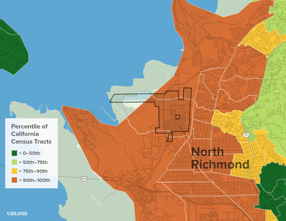
Vulnerable Populations

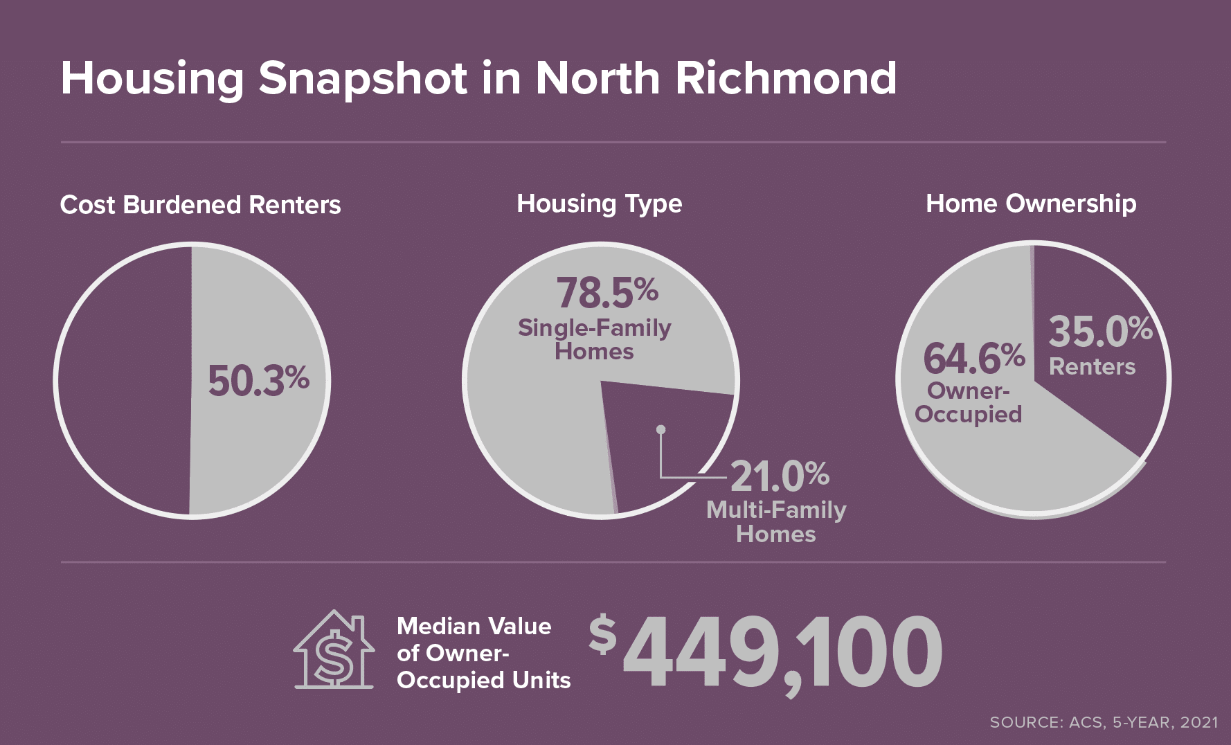
Flood impacts are not distributed or experienced equally—residents already experiencing housing insecurity, economic stresses, and health conditions are more likely to be adversely impacted by climate change.

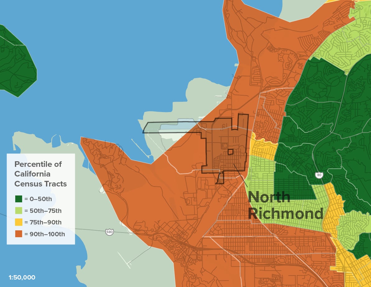
Social Vulnerability and Sea Level Rise
1. BCDC Community Vulnerability Rank
2. With 108" SLR

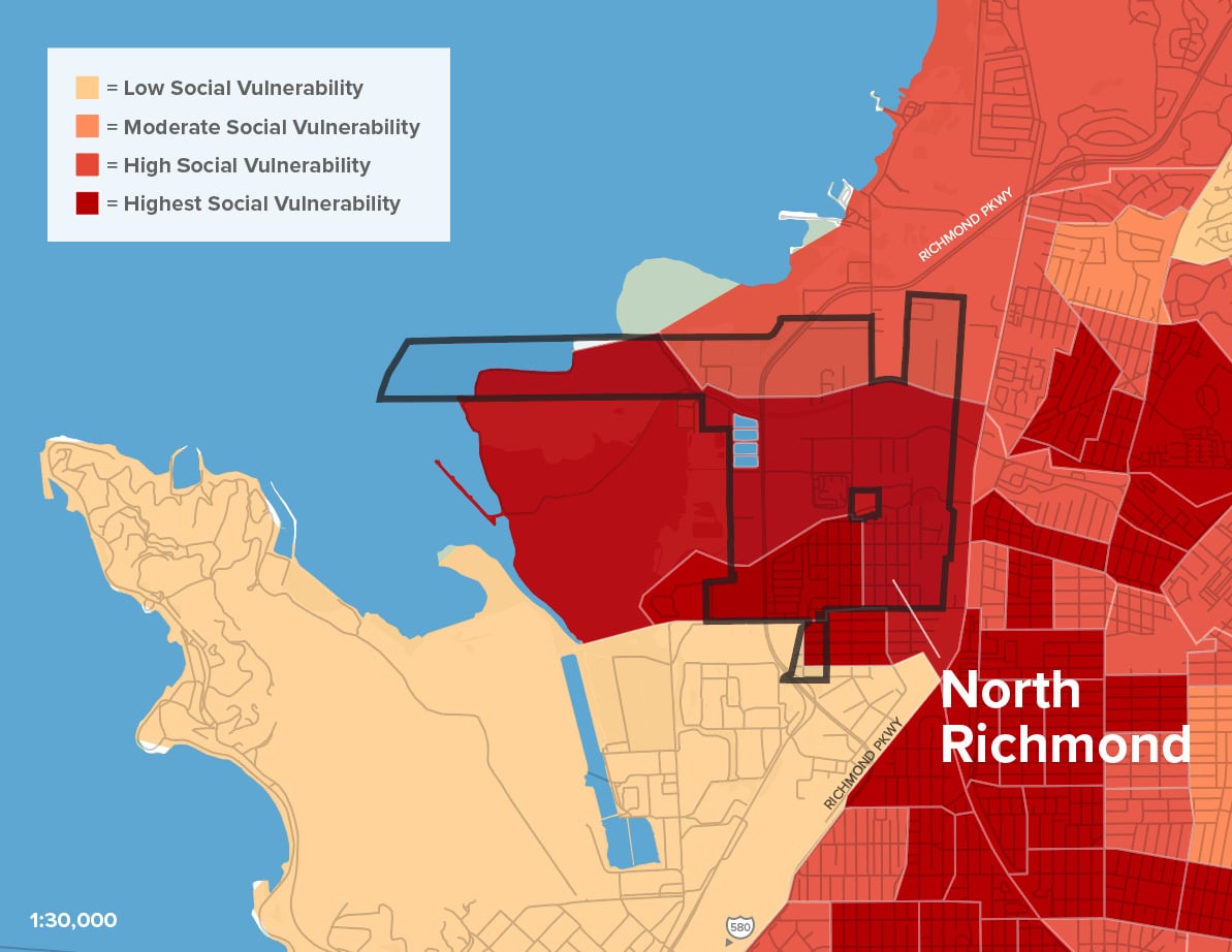
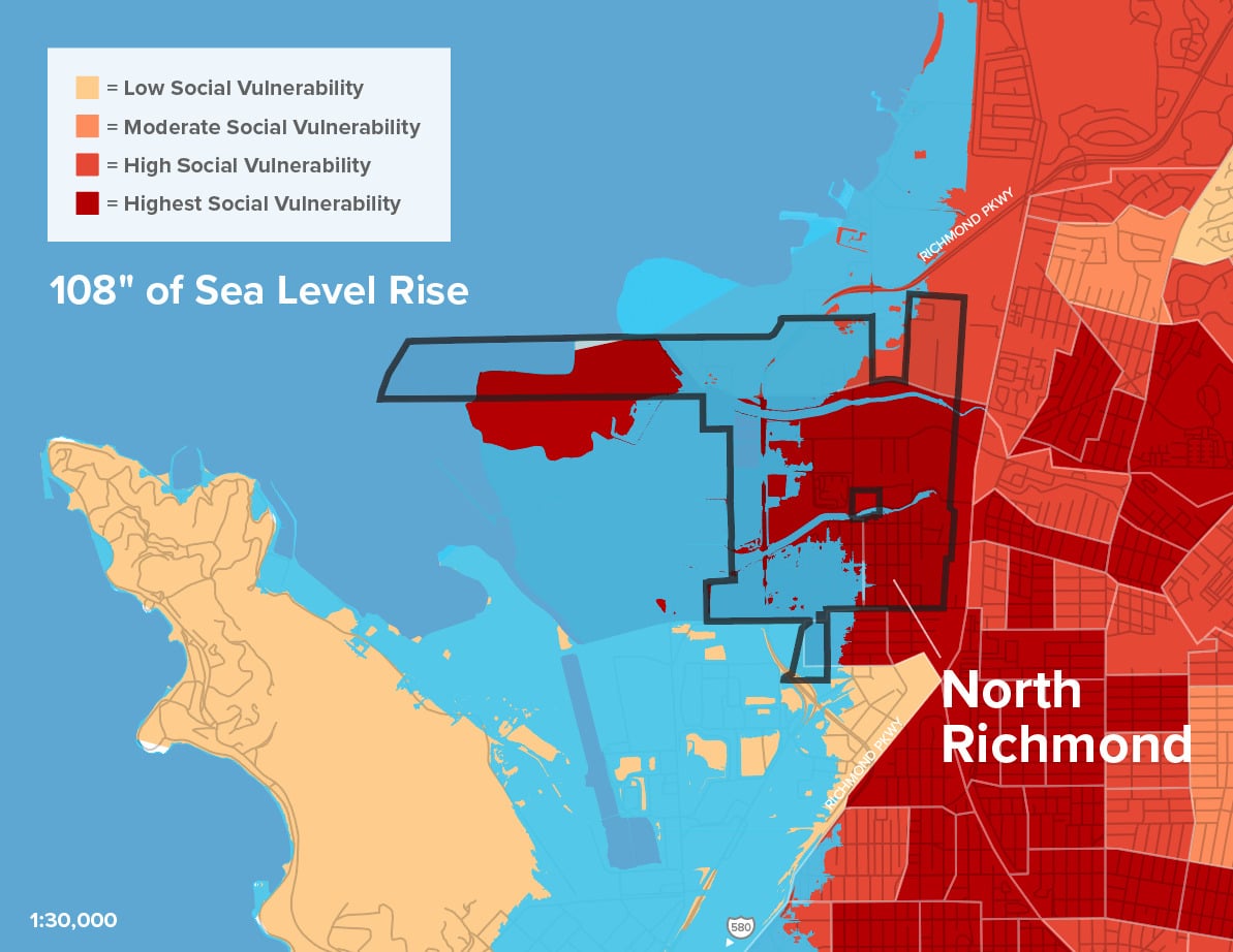
North Richmond has faced decades of environmental injustice and state-sanctioned discrimination that can still be seen today through the clustering of toxic land uses, its unincorporated status, and the relative lack of infrastructure and services to serve the community.

Decades of discrimination cannot be undone overnight, and while local advocates have achieved amazing success in limiting further harm, the North Richmond community remains one of the lowest income areas in Contra Costa County. 

Income and race are two of the largest social factors determining how a community experiences and is able to recover from climate events. While North Richmond’s residential communities are not forecasted to be directly impacted by flooding until the end of the century, flood impacts will cause disruptions to the community much sooner in the form of transportation interruptions and impacts to water and sewer utilities.

Map Citations:

Bay Conservation and Development Commission (BCDC). 2020. “Community Vulnerability.” Accessed June 20, 2023.
https://bcdc.maps.arcgis.com/home/item.html?id=5a14b281c5c9402e81dfdcc29d0a387c
Adapting to Rising Tides: Bay Conservation and Development Commission (BCDC). 2020. “ART Bay Area Sea Level Rise and Shoreline Analysis Maps.” Accessed June 2, 2023. https://explorer.adaptingtorisingtides.org/download.

Infrastructure & Contaminants at Risk

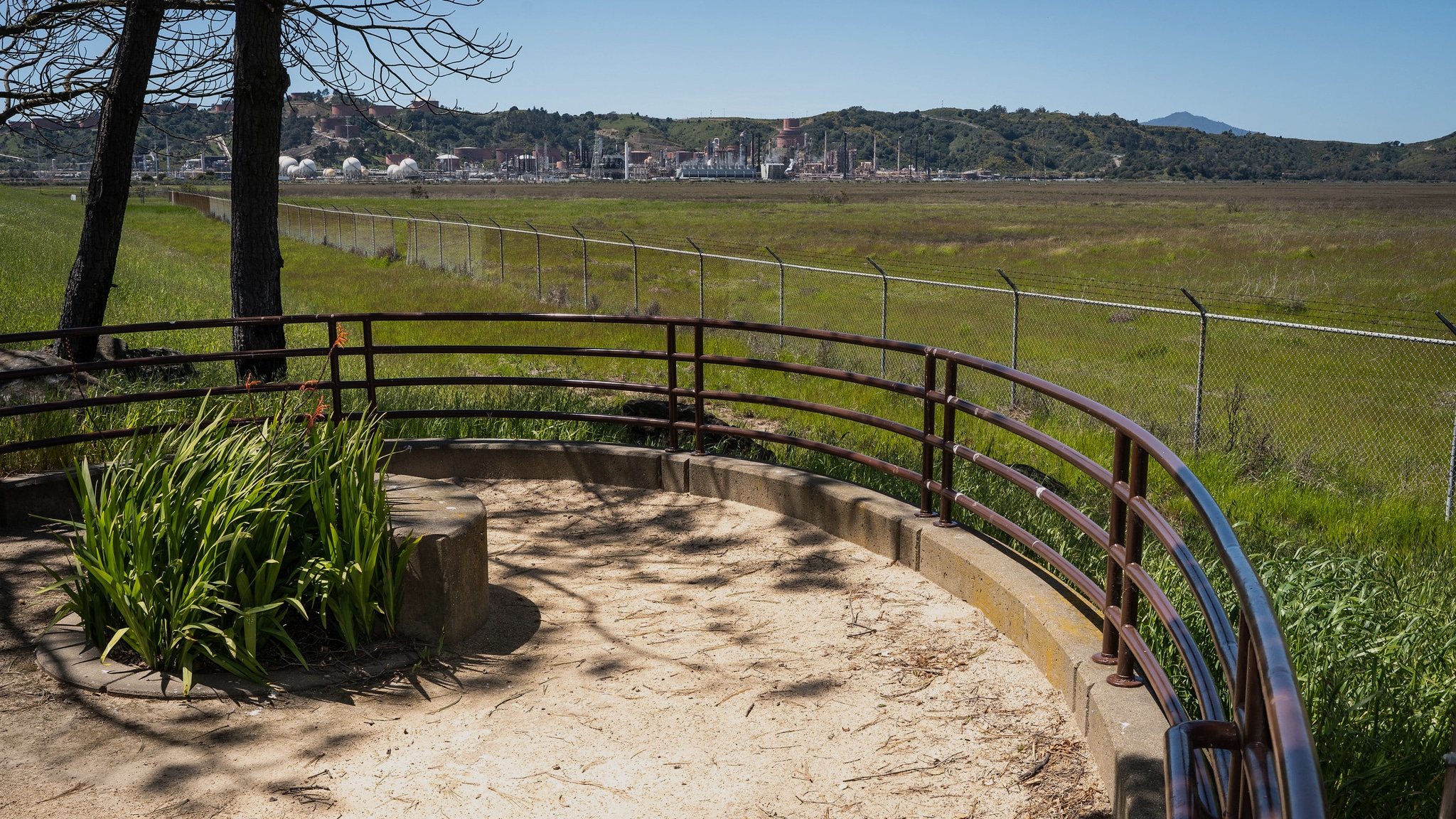
North Richmond’s shoreline is home to infrastructure and uses that are at high risk of flooding—disrupting the region as a whole and posing significant risk to neighboring communities that will face contamination and severe public health impacts if harmful toxins are deployed from the flooding of industrial lands.

The West County Wastewater District, which treats and disposes of wastewater for roughly 34,000 residents and 900 businesses, operates a sewage treatment plant in North Richmond that is highly vulnerable to sea level rise impacts.

Adjacent to this facility are the Golden Bear Transfer Station (dump) and the Republic Services Landfill, which are similarly at risk of flooding and pose significant risk of chemical leakage into the area’s water systems.

West of Richmond Parkway is a clustering of industrial uses as well as a pump station on West Gertrude Avenue, which had emergency repairs in 2020 and is currently a vital piece of infrastructure responsible for pumping water out of North Richmond. This infrastructure is in dire need of repair.

Chevron’s adjacent refinery operations are chemically intensive and pose another risk to the community if toxins are exposed.

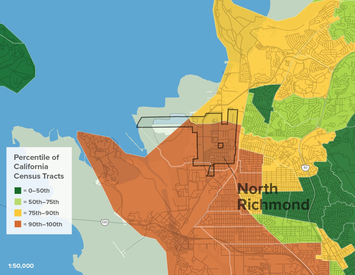
Sea Level Rise Risks Exposing Contaminants

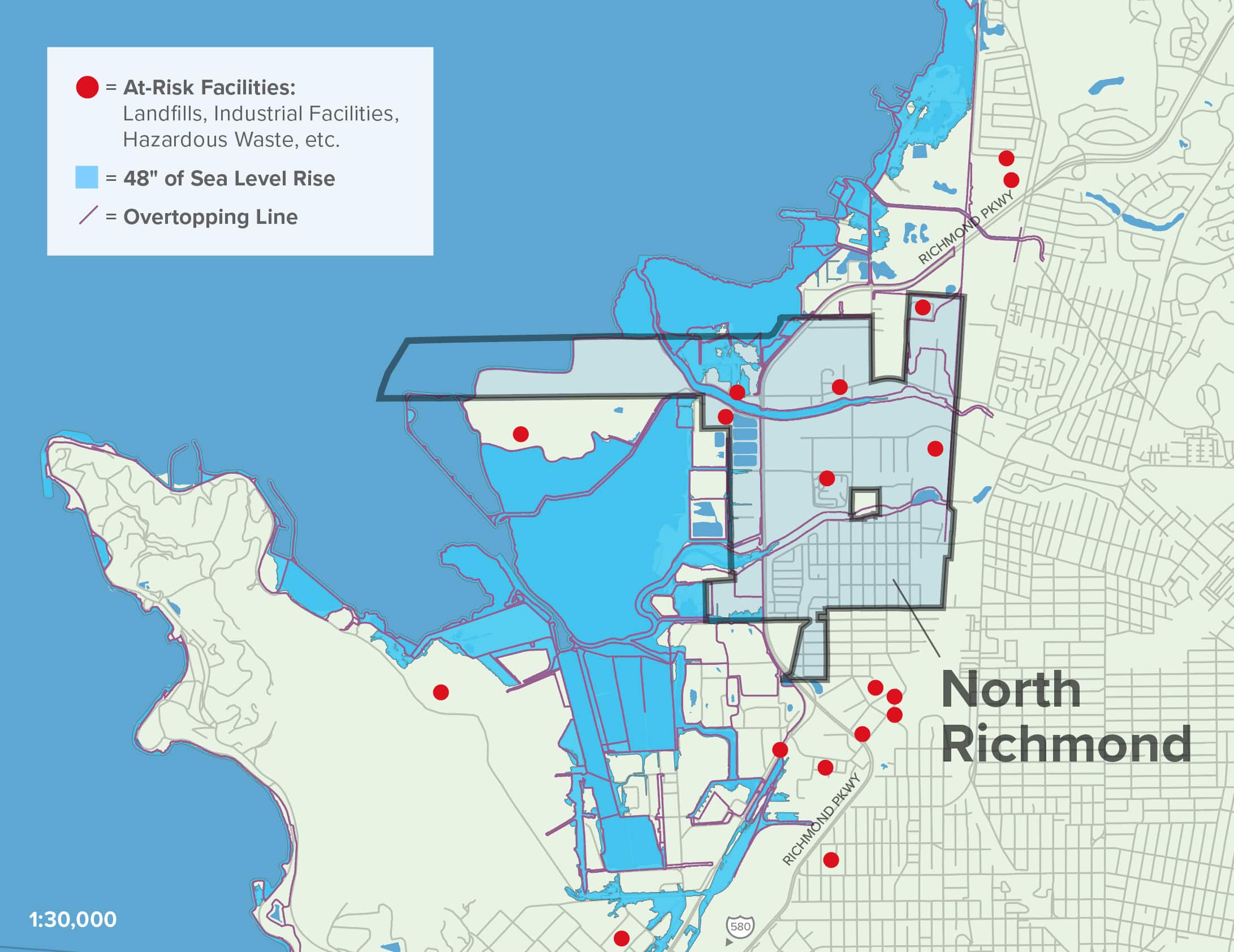
Flooding, sea level rise, and shallow groundwater conditions, in tandem with an inadequate water and sewer infrastructure, can expose these harmful contaminants, which may leach into groundwater and pose serious public health risks.

Remediation of harmful contamination will be extremely difficult and expensive, potentially resulting in mass displacement of residents.

Map Citations:

UC Berkeley: Toxic Tides. 2020. “Mapping Exposed Facility.” Accessed June 22, 2023. https://sites.google.com/berkeley.edu/toxictides/case-studies.
Adapting to Rising Tides: Bay Conservation and Development Commission (BCDC). 2020. “ART Bay Area Sea Level Rise and Shoreline Analysis Maps.” Accessed June 2, 2023. https://explorer.adaptingtorisingtides.org/download.

Conservation
& Sprawl

The bayshore adjacent to North Richmond was originally tidal marshlands and tidal flats, dotted with salt ponds. Over the last two centuries, much of these marshlands have been built upon. However, a combination of living levees, marsh stewardship, and nearshore reefs and vegetation can protect communities while also restoring ecological functions and providing vital recreation and Open Space Land.

Sprawl Risk & Unprotected Lands

North Richmond’s relative affordability of land has made it an attractive location for recent development of logistics centers and other Light Industry uses. These have been mostly clustered on the previously undeveloped northside of the community, but there are a number of sites at risk of sprawl development near the bayshore as well. The lack of protection for the Wildcat Marsh and other open spaces leaves North Richmond at risk.

Essential and Important Lands for Conservation Goals and Sprawl Risk
1. Conservation Land Network
2. Sprawl Risk

North Richmond is geographically cut off from other neighborhoods by warehouses, rail yards, and train tracks, due to decades of discriminatory land-use policies and industrial activity. To prevent further harm, the County must limit new industrial uses and instead prioritize dense housing like apartment buildings, tiny homes, and townhomes to accommodate growth and reduce the risk of displacement.

Map Citations:

Conservation Land Network: Together Bay Area.”Full CLN 2.0 GIS Database (Version 2.0.1)” Accessed July 12, 2023. https://www.bayarealands.org/maps-data/#maps.

Greenbelt Alliance. 2017. “At-Risk 2017 GIS Data.” Accessed February 20, 2023. https://www.greenbelt.org/at-risk-2017-gis-data/.

Opportunities for Nature-Based Solutions

North Richmond is in the perfect location to leverage nature-based solutions to reduce the impact of flood events while simultaneously establishing greater connectivity between the Bay and community—restoring ecological functions, and providing a multitude of community benefits. 

Recommended Nature-Based Solutions

Through years of research and partnership among the San Francisco Estuary Institute, Contra Costa County’s Watershed Program, the West County Wastewater District, and local advocates like the Watershed Project, a living levee concept and comprehensive strategy for nature-based resilience have been advanced to the point of conceptual designs. Click here for further detail on this process.

SFEI Adaptation Atlas: San Francisco Estuary Institute (SFEI). 2019. “San Francisco Bay Shoreline Adaptation Atlas GIS data, Version 3.” Accessed June 1, 2023. http://www.sfei.org/data/adaptation-atlas-data.

Governance

The community of North Richmond is a perfect example of Municipal Underbounding. Their unincorporated status makes equitable planning and decision-making a challenge, while also limiting residents’ ability to participate in local democracy and have their needs adequately addressed.

To help remedy this, the County has established Municipal Advisory Committees (MACs) for each unincorporated community that are tasked with advising on various matters. While the North Richmond MAC has been an important method of working with the County to prioritize the area, there remains a gap when planning for sea level rise and flood hazards.

Strong local partnerships are key to developing long-term strategies for climate resilience. But without appropriate governance and political will, it can be hard to make great plans materialize into on-the-ground projects.

Social &
Health

North Richmond community organizations have been actively fighting discrimination for decades. Its unincorporated status, environmental risk factors, and regional centrality have made it a location for locally unwanted land uses (LULUs) like dumps, sewage plants, and industrial facilities. These clustered uses have resulted in significant disparities in public health when comparing local outcomes to county averages. In the context of climate resilience, understanding social and economic factors is key to positioning communities with the resources necessary to achieve an equitable climate future. In North Richmond, achieving safe and affordable housing for residents is a priority.

Housing

Housing in North Richmond is relatively affordable compared to the rest of the Bay Area, but that is partially a product of aging, badly-maintained housing stock, and poor infrastructure.

North Richmond residents are vulnerable to gentrification and displacement pressures due to the area’s proximity to Bay Area job centers and the current lack of affordable housing.

Flooding and other climate shocks and hazards have been found to result in negative impacts to renters in particular, since they are not eligible for disaster recovery funds or insurance payouts.

Renters are impacted indirectly by climate events that reduce the supply of housing and can cause acute increases in rental prices. This can result in temporary and permanent displacement for residents who are housing insecure.

Through the Resilient by Design process and subsequent work, the North Richmond community has established that traditional housing approaches aren’t applicable to the region. Instead, North Richmond has called for health and wealth building policies and strategies that are able to use land trusts and small sites as building blocks for supporting homeownership as a key climate resilience strategy.

Transportation & Jobs

North Richmond plays a key role in the region’s transportation and goods movement due to its logistics centers and its location adjacent to Amtrak. However, these same warehouses, highways, and railroad tracks also isolate residents from adjacent neighborhoods, services, and amenities due to the lack of adequate transit and multimodal infrastructure.

North Richmond is home to nearly 2,000 jobs in various industries, with roughly 64% of those jobs in the construction, manufacturing, and wholesale industries, 20% in waste management, and 11% in transportation. Most of these jobs are occupied by non-residents.

North Richmond residents themselves have a very different range of jobs, with 28% of residents commuting over 25 miles to work. Since the community has no high quality transit stops (CA HQ Transit Stops, Caltrans), this jobs-housing imbalance results in additional Vehicle Miles Traveled (VMT) and associated Greenhouse Gas Emissions (GHGs).

Pollution Burden & Public Health

North Richmond residents face disproportionate exposure to environmental hazards, with measurable impacts to health outcomes and public safety. Planning for a climate-resilient future must include strategies for facilitating a just transition and achieving community health outcomes through nature-based approaches.

CalEnviroscreen Data (using percentile rank for all census tracts in California)
1. Cumulative Environmental Risk
2. Clean-Up Sites
3. Hazardous Waste Exposure
4. Asthma

According to the California Environmental Protection Agency’s CalEnviroScreen 3.0 report, North Richmond ranks among the highest census tracts in the state for hazardous waste facilities, clean-up sites, and solid waste sites. It is also classified as a state-designated disadvantaged community. As a result of these clustered pollutants, North Richmond residents experience lower life expectancy (compared to the county) and higher rates of cardiovascular disease and asthma.

Diesel pollution from traffic serving local industries, clusters of brownfield contamination sites, repetitive toxic releases from the Richmond Chevron Refinery, and freight activity and port operations are some examples of activities that have resulted in these health disparities.

North Richmond was selected for participation in the Community Air Protection Program (AB 617), which empowers community members to participate in strategizing on how to monitor and mitigate air pollution sources.

Map Citations:

Citation: California Office of Environmental Health Hazard Assessment (OEHHA). 2021. “CalEnviroScreen 4.0 GDB file.” Accessed June 16, 2023. https://oehha.ca.gov/calenviroscreen/report/calenviroscreen-40.

Community Partners

Other Key Partners
& Leaders

Opportunities for Resilience

The following goals and recommended next steps have been informed by conversations and feedback from a variety of local stakeholders as well as a thorough review of past and ongoing documents and studies, with support from data analyses and land-use and planning expertise. 

GOAL

Construct living levee and connected stormwater infrastructure.

NEXT STEPS

Complete designs and secure funding to implement a living levee to protect the community, infrastructure assets, and provide vital co-benefits.

Implement stormwater improvements and green infrastructure projects to mitigate flood risks and improve access to green amenities in the community.

GOAL

Establish a sustainable, long-term funding source and governing body to support the ongoing maintenance and adaptation of green infrastructure.

NEXT STEPS

Collaborate with existing partners and community leaders to evaluate governance strategies that meet project needs.

Identify funding to support the establishment of a selected governance strategy.

GOAL

Sustain and elevate existing local leaders and community-based organizations.

NEXT STEPS

Support and advocate for resources to assist the leadership of local organizations and climate champions in both near-term planning processes and long-term management strategies. 

Support partnerships, advocacy, and collaboration that build wealth and bolster North Richmond’s economic and social resilience

GOAL

Promote the development of affordable housing.

NEXT STEPS

Work with Richmond Land and Contra Costa County to encourage the production of high-density and affordable housing as well as alternative forms of housing like s and small sites.

Take the opportunity presented by The Las Deltas Scattered Sites from the Contra Costa Housing Authority for community land trusts to build affordable housing.

Barriers to Action

  1. North Richmond’s unincorporated status poses significant barriers to action because it results in jurisdictional complexity, inadequate resources, and challenges to participating in local democracy.  
  2. The community’s unincorporated status makes ongoing funding for long-term climate resilience projects, like green infrastructure maintenance, difficult to fund and resource. 
  3. There is no locus of responsibility for the remediation of harmful industrial toxins among local industries, which pose significant and ongoing health risks to North Richmond residents. Remediating toxins is difficult and expensive and may be an even greater barrier than currently understood.

North Richmond Actions & Updates

Contra Costa County Launch Ad Hoc Committee on Sea Level Rise

This September, the Sustainability Commission hosted the first Ad Hoc Committee on Sea Level Rise where they shared plans to prepare a sea level rise and adaptation plan and engage partners from around the county on building resilience.

READ MORE HERE
Greenbelt Alliance Celebrates Earth Day in North Richmond

North Richmond’s resilient spirit was front and center at the Earth Day Festival at Shields-Reid Park on April 20th, 2024. The local community showed up for a lively celebration that invited family and friends to engage with local and regional organizations advancing environmental and social projects throughout North Richmond.

READ MORE HERE
Take a Self-Guided Walking Tour

The Watershed Project has created a self-guided walking tour of North Richmond that stretches between Verde Elementary to Fred Jackson Way.

FIND OUT MORE HERE
Volunteer with Urban Tilth

Want to get your hands dirty and learn about community farms and gardens? Urban Tilth has been rooted in North Richmond since 2006 to educate youth on food systems,  build food sovereignty, and expand farms and gardens in the community.  Get involved through monthly volunteer days.

GET INVOLVED
Scroll to Top