What Makes Suisun City a Hotspot?

Suisun City is facing intersecting challenges of sea level rise and inland flooding which will affect a predominantly low-income community.

Today there are active community members and leaders dedicated to addressing these challenges through nature-based solutions that harness the power of natural landscapes to protect the region’s lands and future generations for a changing climate.

Quick Data

TOTAL POPULATION: 29,436

Population by Race

Cost Burdened Renters

History

TIME IMMEMORIAL

The Suisun, a band of Patwin tribe, lived and stewarded the land around the Suisun Marsh.

1850s

The area known as Suisun City was colonized by European settlers and became an important linkage between the Bay, Delta, and Sierras for the movement of goods and people during the Gold Rush.

1860s

The first discussions began about stopping tidewater from entering the Suisun Marsh in order to control salinity.

1869

The Transcontinental Railroad was finished, with a stop in Suisun.

1963

The Suisun Resource Conservation District (RCD) was founded as the Suisun Soil Conservation District.

1965

The Bay Area Conservation and Development Commission (BCDC) was founded as the nation’s first coastal zone agency.

1974-1977

BCDC established the Suisun Marsh Protection Plan, AB171: Suisun Marsh Protection Act of 1977.

1987

The Plan of Protection for Suisun Marsh was established.

1990s

Suisun’s Downtown Specific Plan was revised to include:

  • $58 Million in tax-increment bonds to provide overall downtown design.
  • Dredging and restoration of the Suisun Channel.
  • The Crescent District as a redevelopment area, which was then torn down and replaced with Victorian Harbor.
2000

CALFED Suisun Marsh Charter was established.

2011

Suisun Marsh Habitat, Preservation, and Restoration Plan was completed, to be implemented over the next 30 years.

2015

The City adopted the 2035 General Plan to serve as guiding policy for development for the following two decades.

2022

The most recent Hazard Mitigation Plan was adopted, which sets mitigation long-term goals, objectives, and priority actions.

JUNE 2022

A community resilience-building workshop was held. Participants included Suisun residents, The Nature Conservancy, Sustainable Solano, BCDC, Mayor Hernandez, and others.

JUNE 2022

Suisun City won the Mayors’ Climate Protection Award for a small city for the Citywide Energy Infrastructure and Efficiency Program.

PHOTO BY LOREM IPSUM

Climate Vulnerabilities

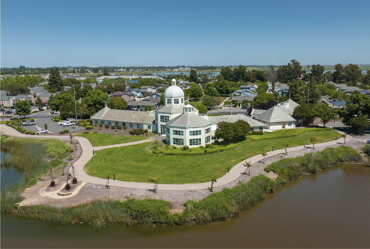
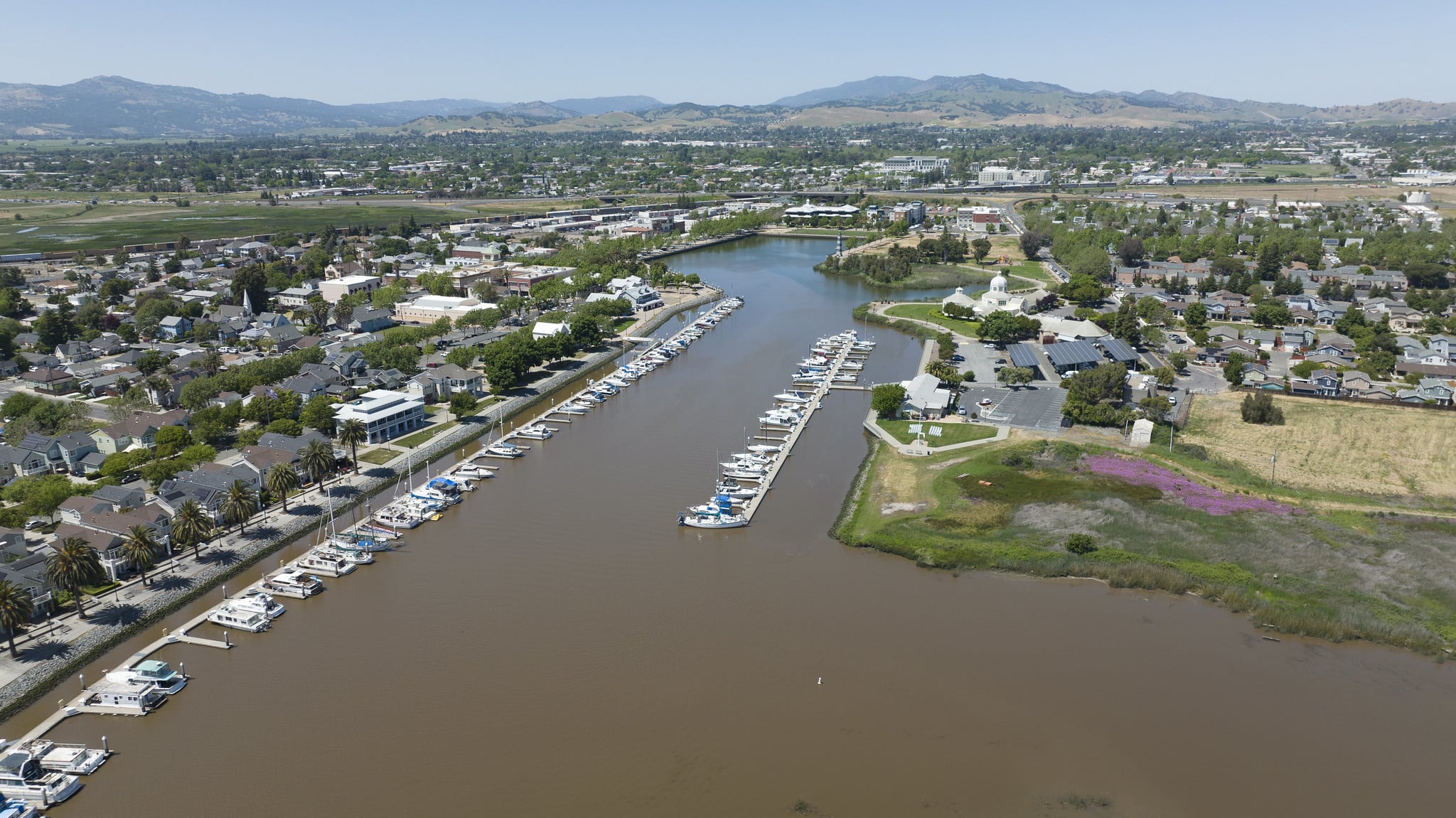
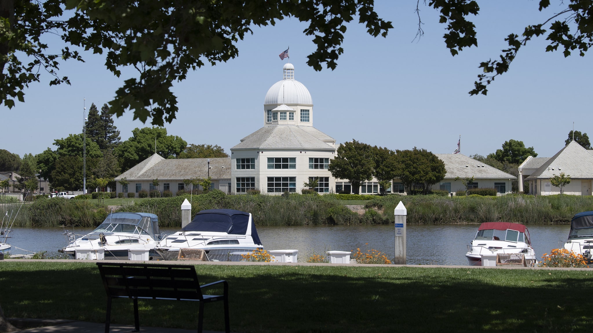
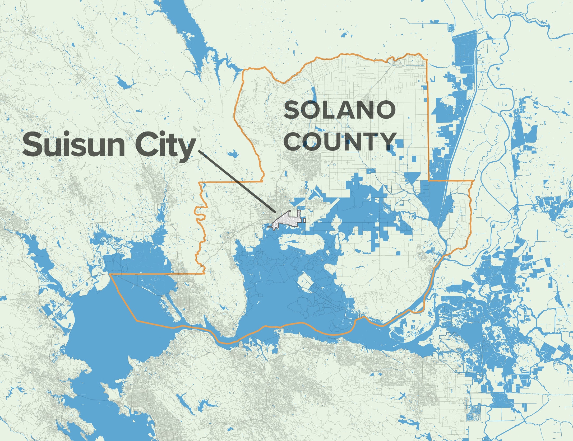
Suisun City’s waterfront location has drawn people to this special place for centuries, but rising seas pose a near-term threat to the city itself, as well as to its neighboring wetland and marsh habitats.

While the areas south of Highway 12 will have to contend with sea level rise sooner than the rest of the city, the impacts to transportation, services, and housing will send shocks throughout the region—affecting low-income and housing-insecure people the most.

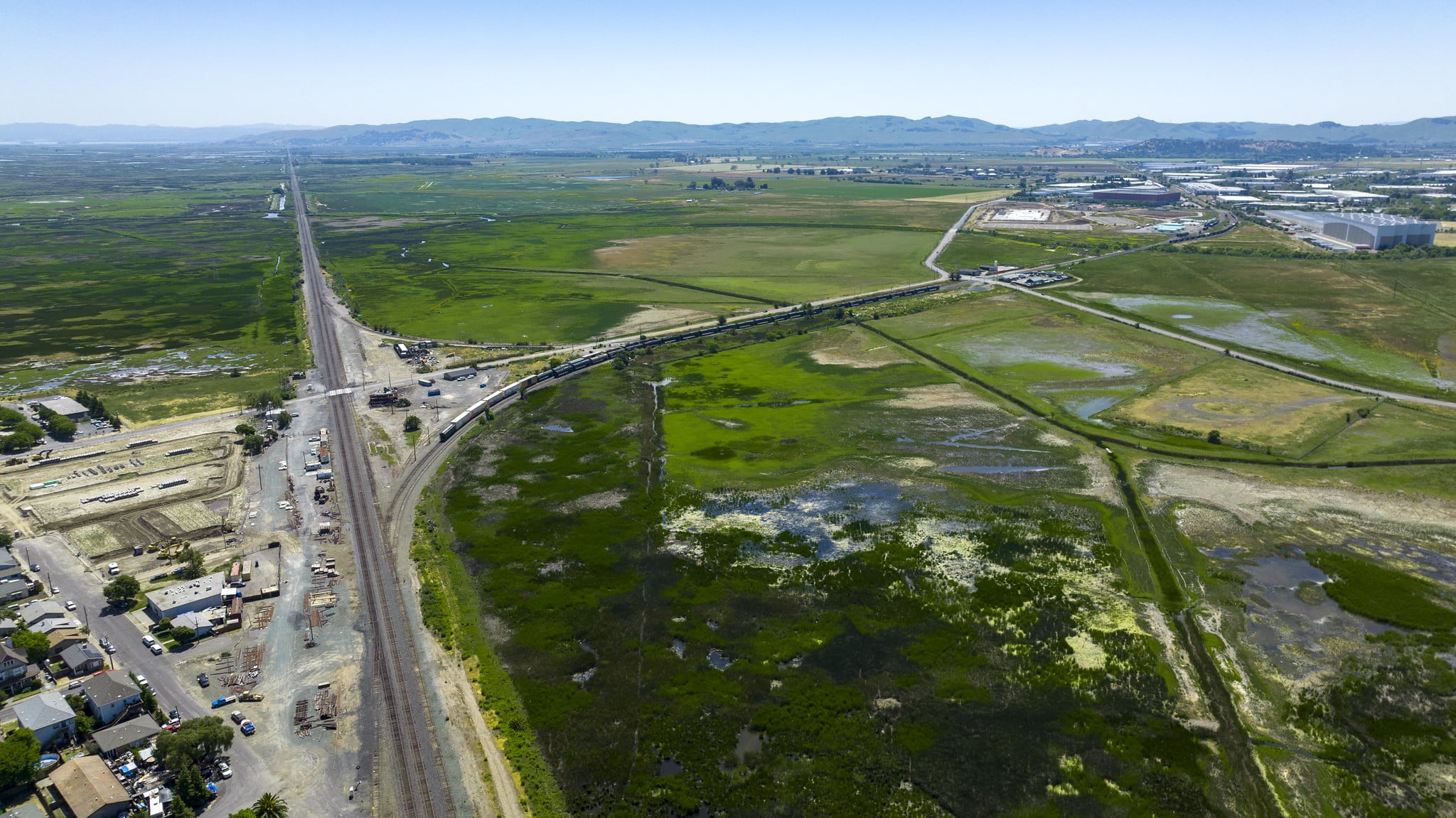
Flood impacts will substantially shape Suisun’s future over the long term, but recent wildfire events in the Marsh have elevated wildfire safety to be a key near-term priority for residents.

Inland Flooding & Sea Level Rise

Suisun is on the frontlines of sea level rise and has the opportunity to set a powerful example for places across the Bay Area and beyond of how to plan equitably for this, and other, climate impacts.

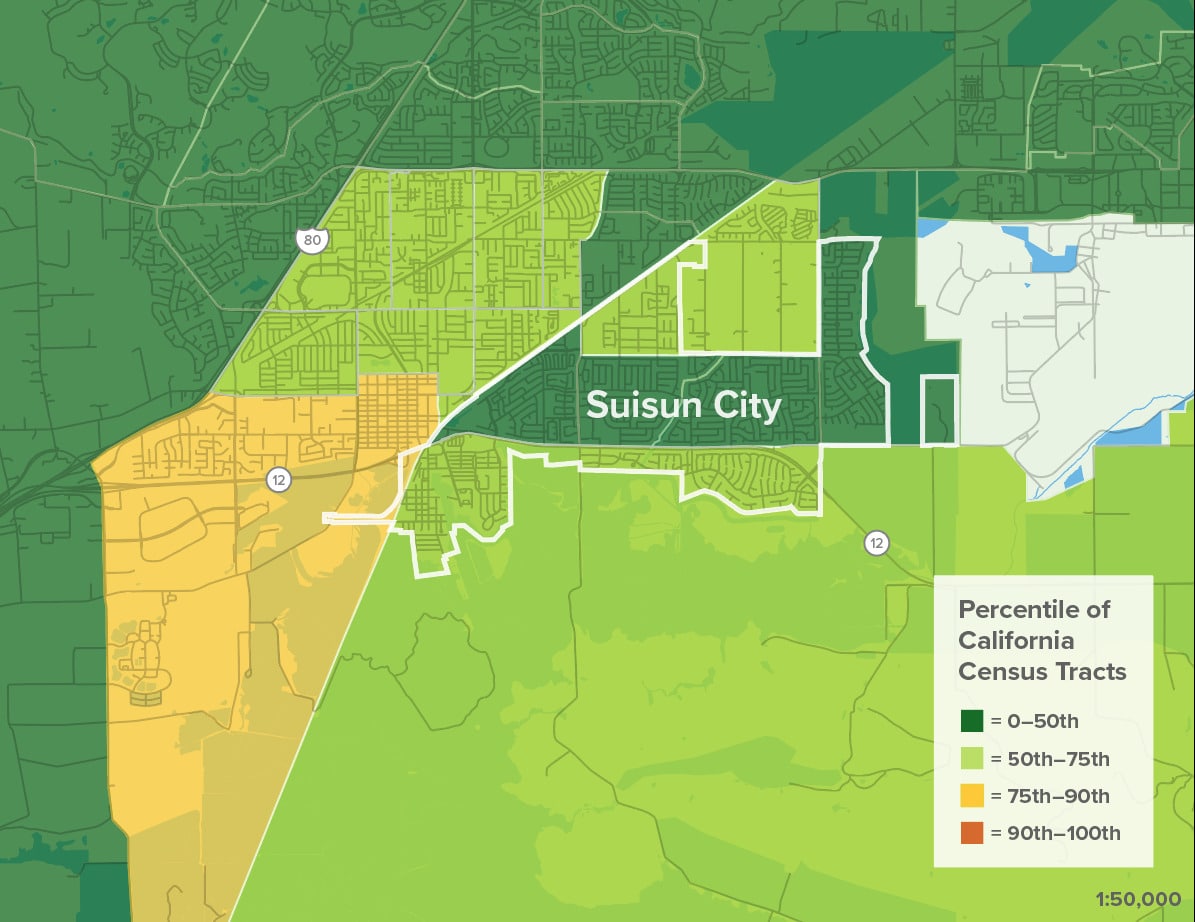
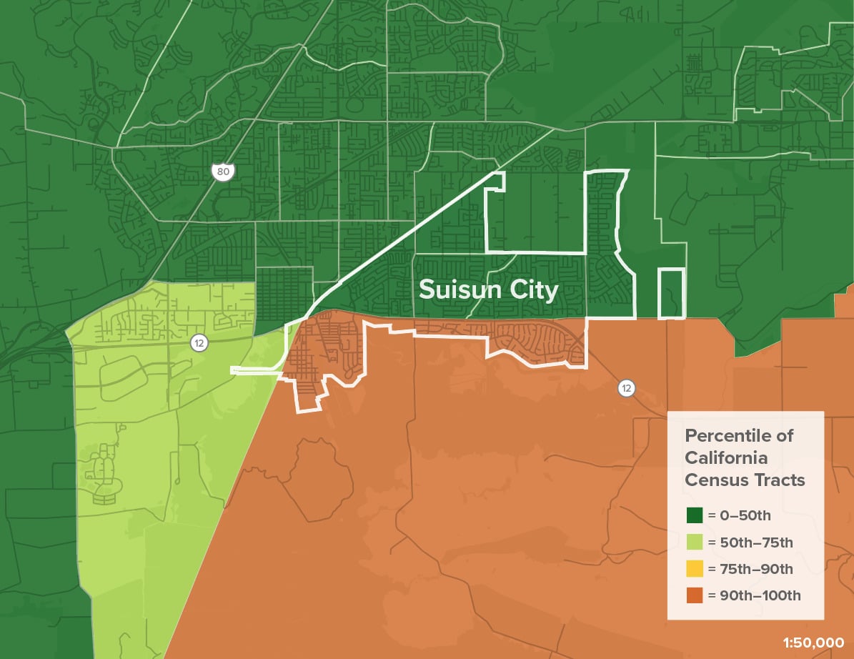
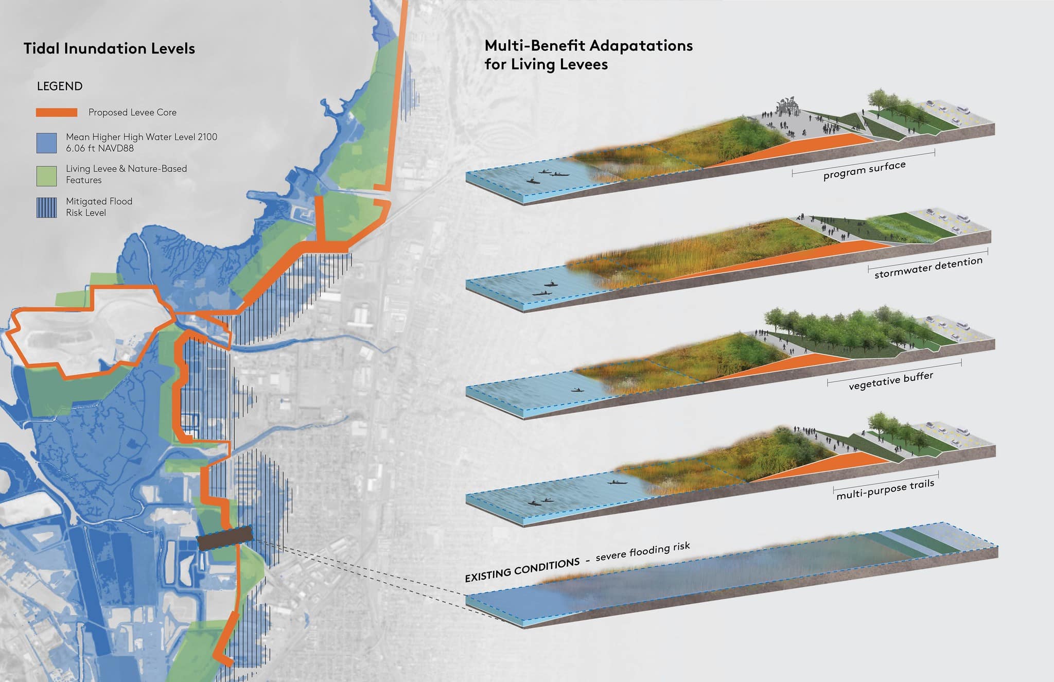
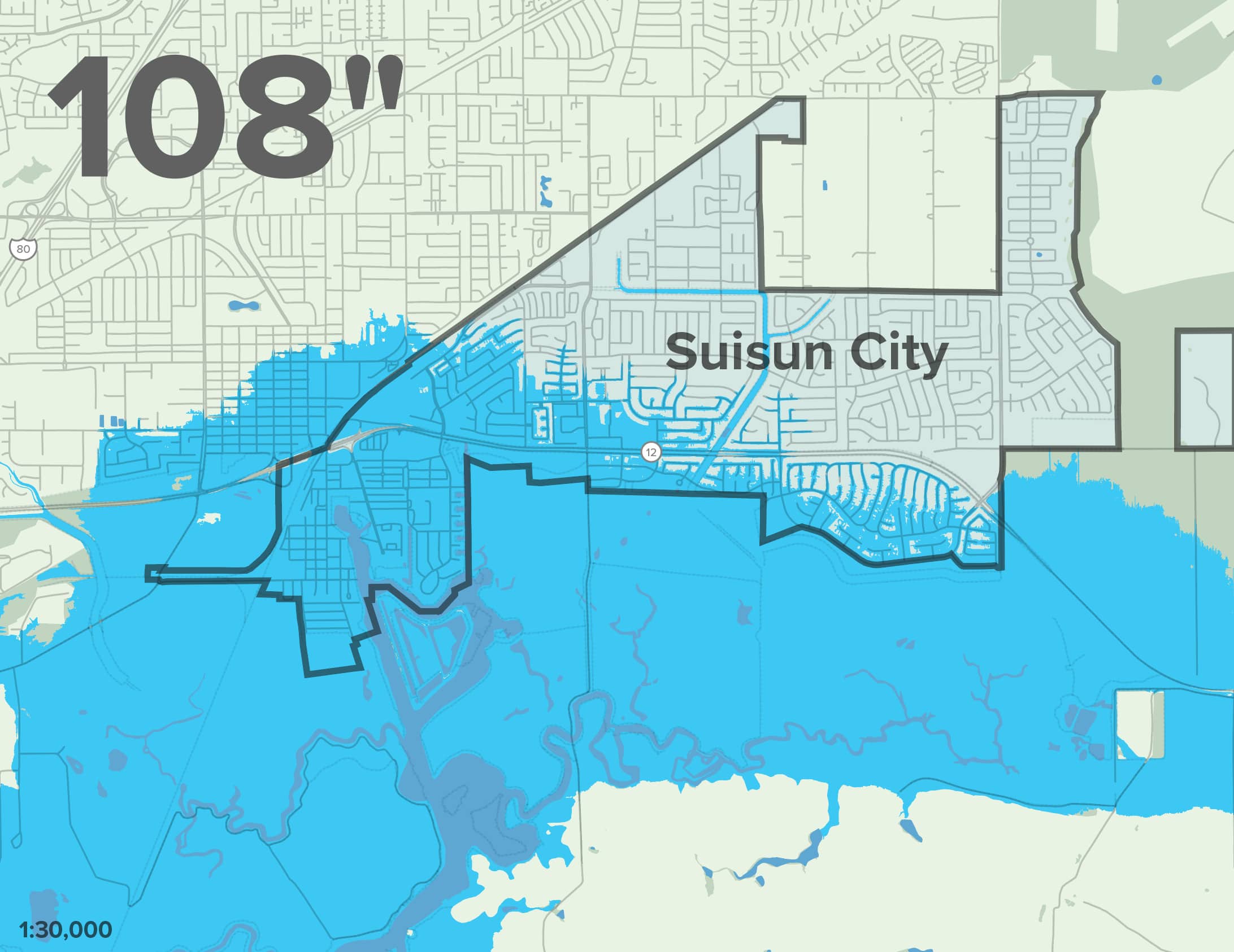
Projected Sea Level Rise in Suisun City
0
108

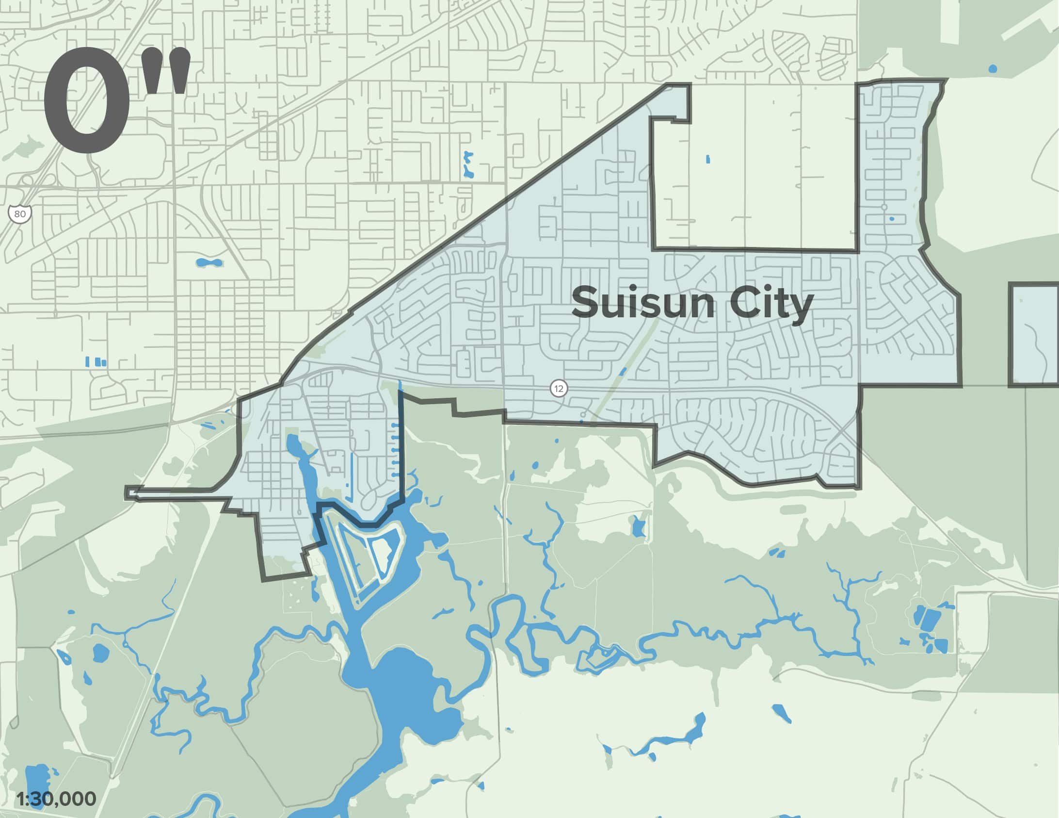
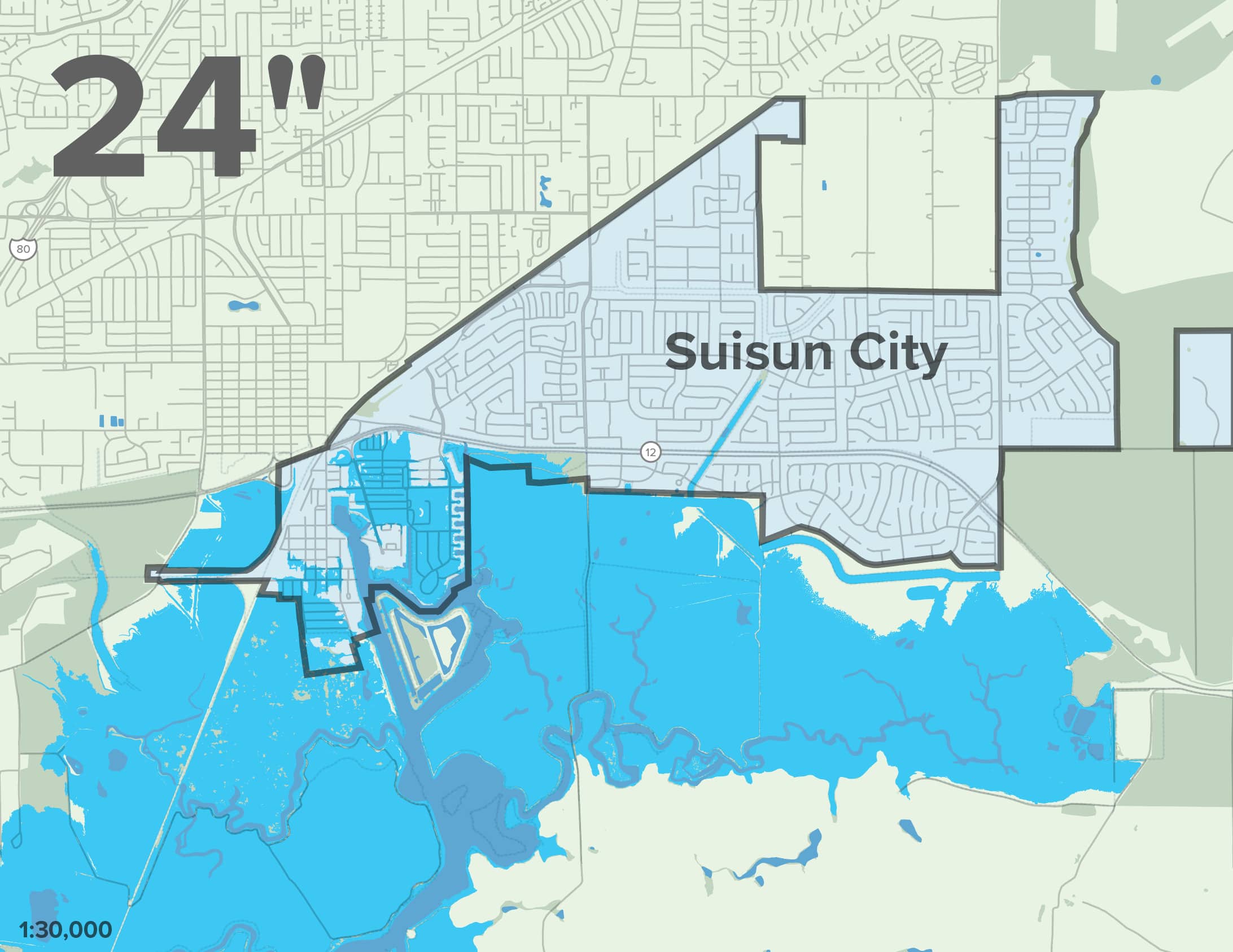
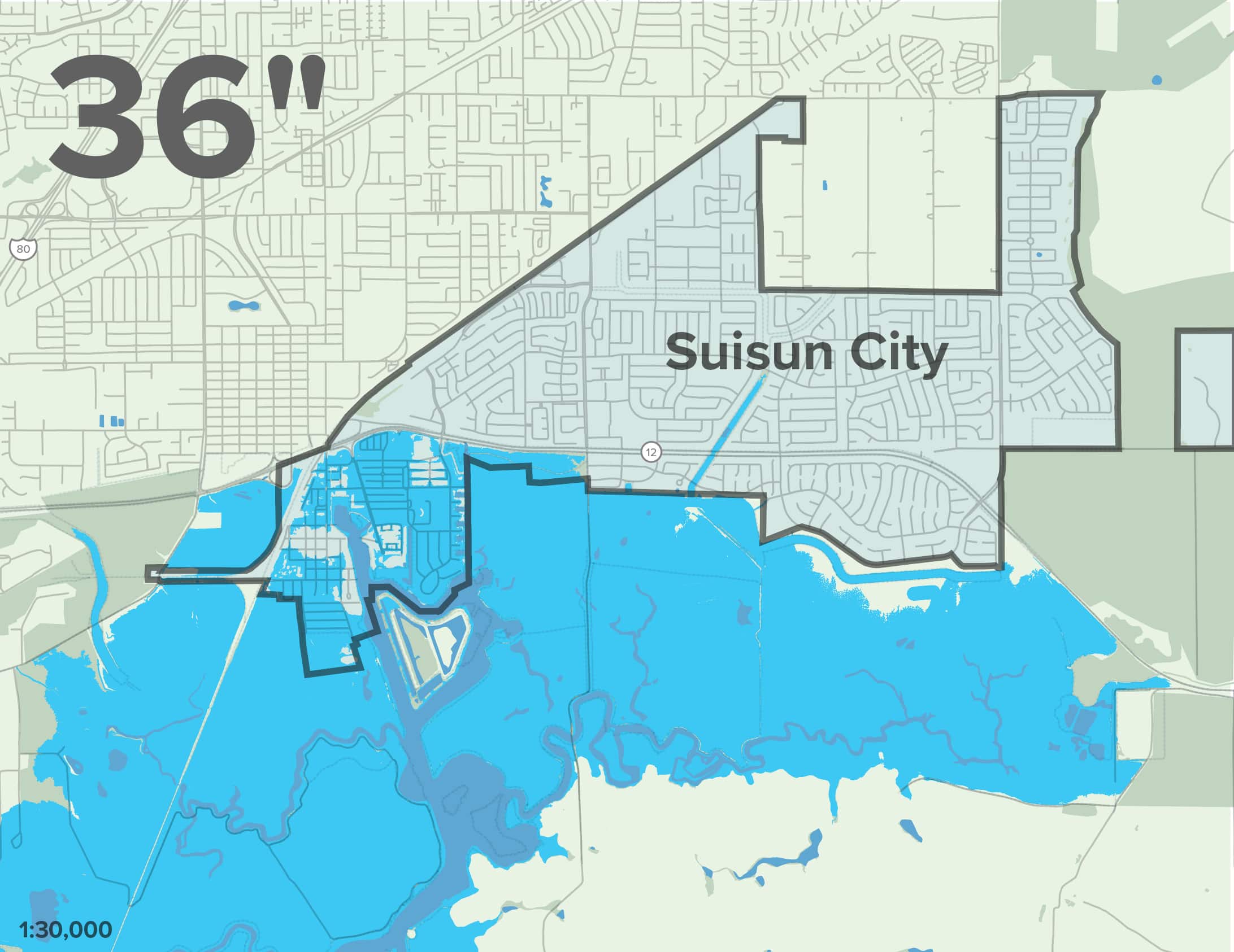
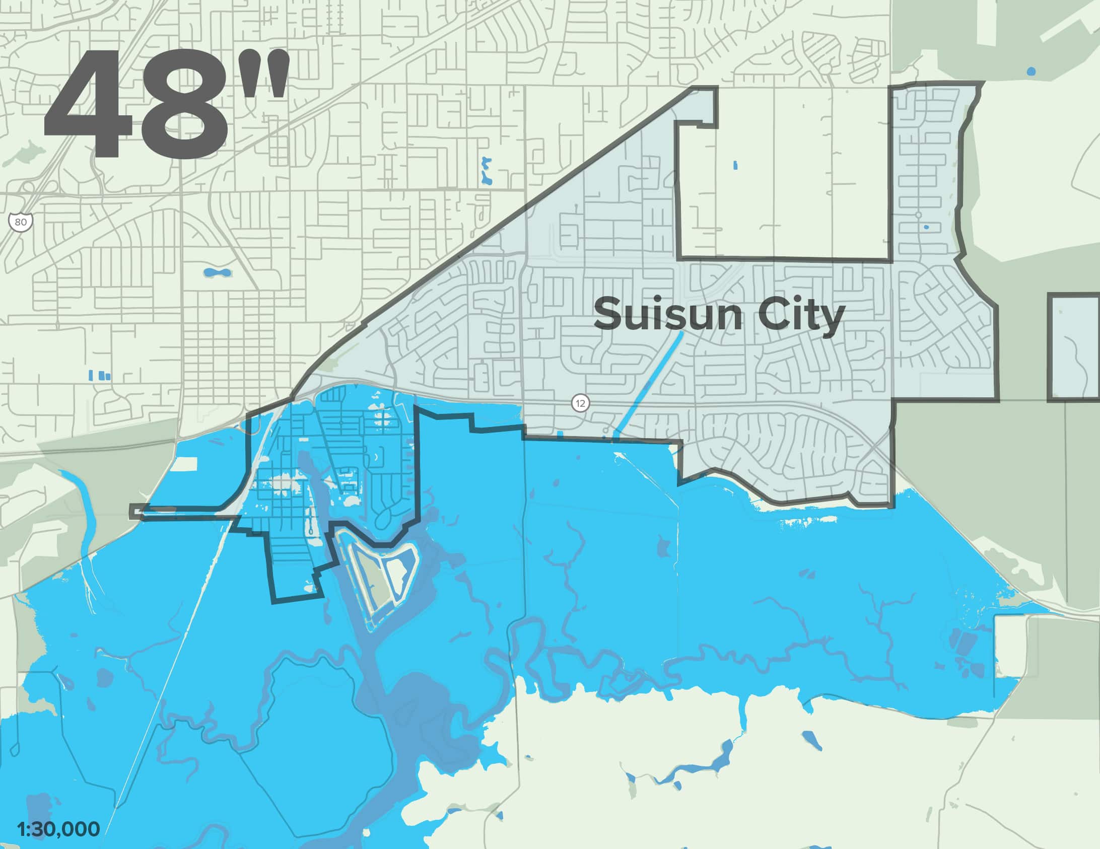
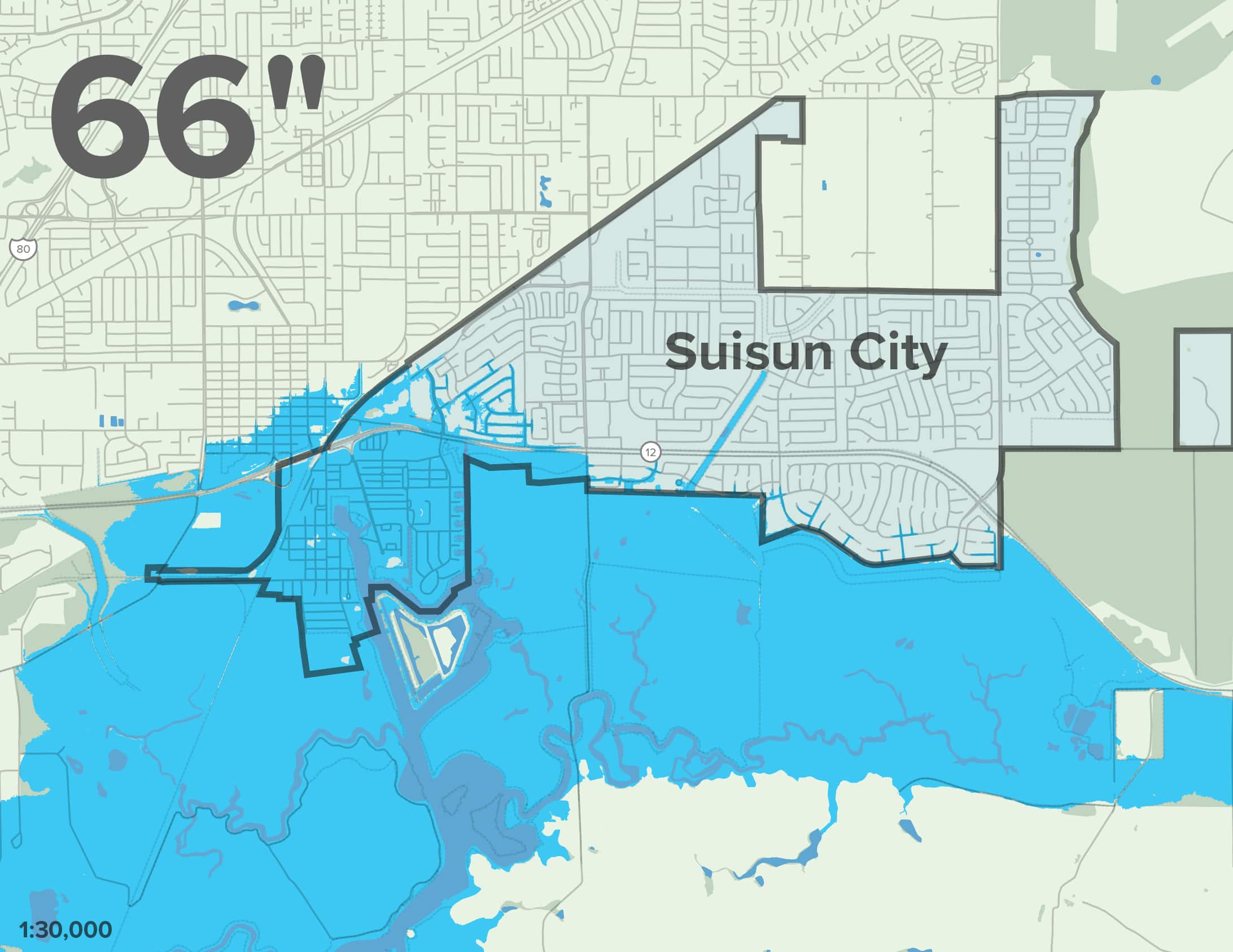
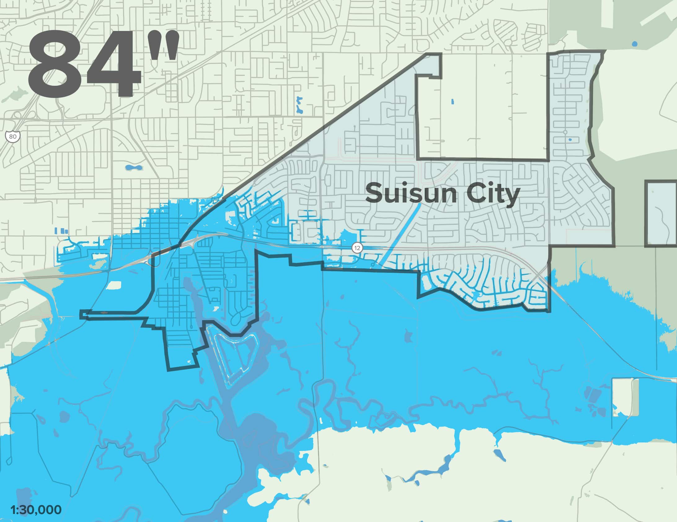
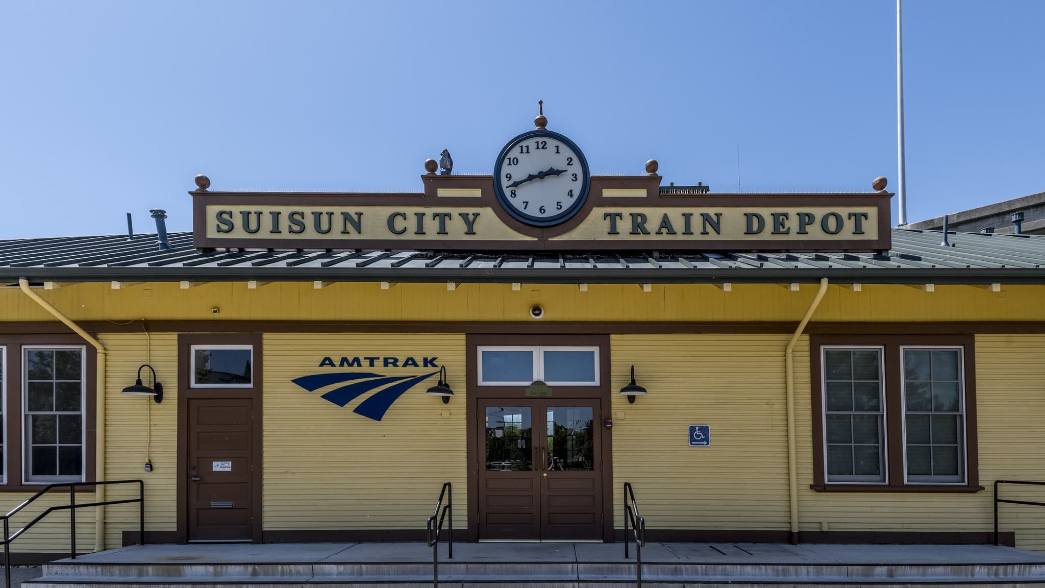
By 2050, most of the area south of Highway 12 will experience multiple feet of flood inundation, which will impact the downtown Waterfront District, City Hall, Crystal Middle School, Amtrak, homes, and industry.

With 108 inches of sea level rise expected by 2100, the majority of Suisun will be more than five feet underwater.

Rising seas will be a powerful force dictating the city’s future, but with early planning and action, Suisun can be a model for small cities adapting to higher water levels. Suisun can lead the way in actualizing a vision for healthy, thriving cities that are living with higher water levels.

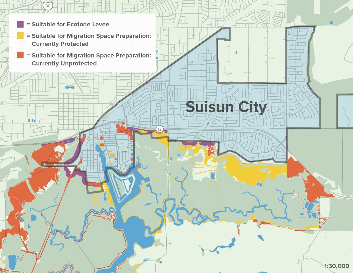
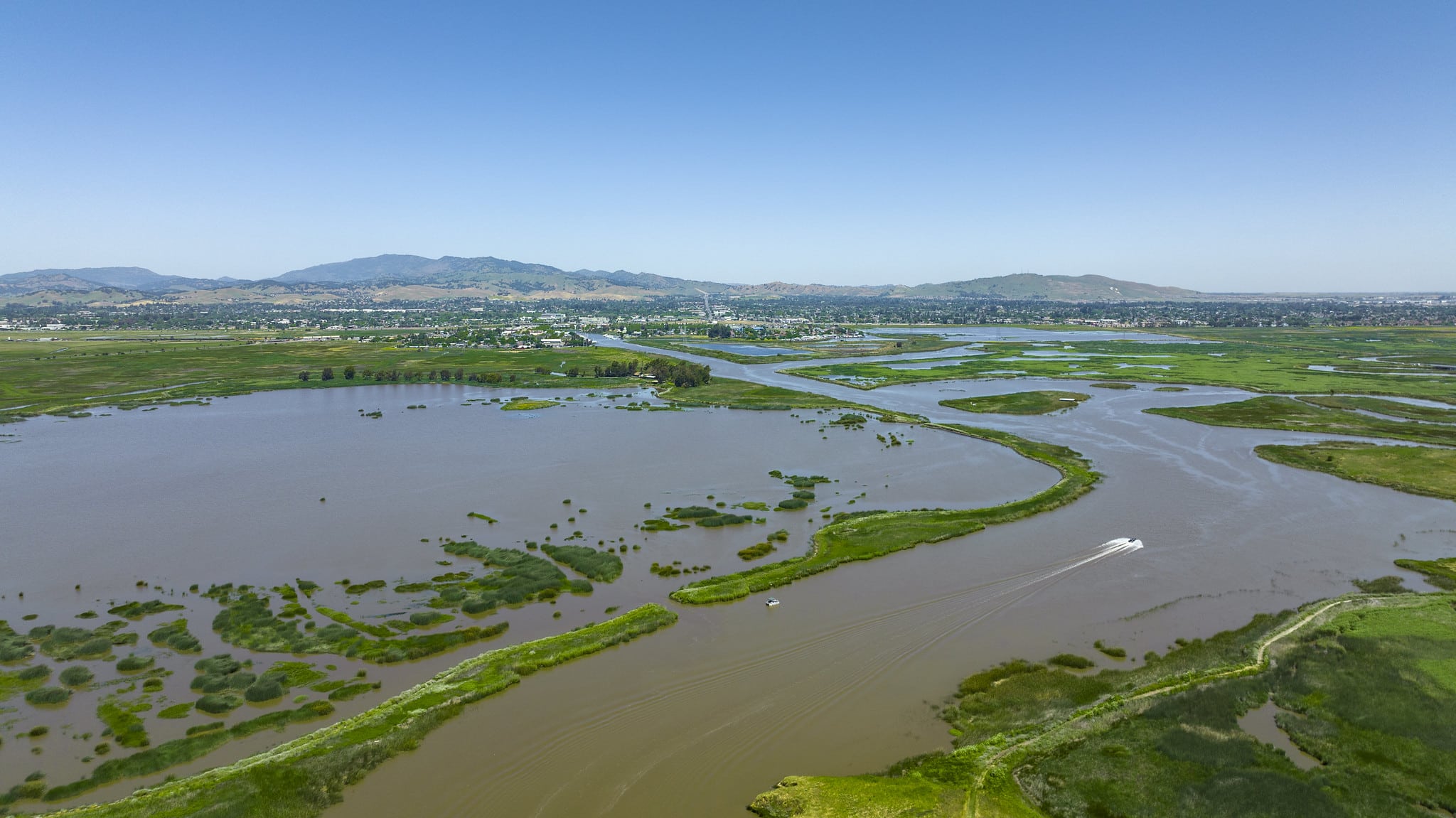
The Suisun Marsh provides unique opportunities such as “Green Infrastructure” and “Gray Infrastructure” for sea level rise adaptation that simultaneously maintains the region’s ecology and provides recreational opportunities.

Map Citations:

Adapting to Rising Tides: Bay Conservation and Development Commission (BCDC). 2020. “ART Bay Area Sea Level Rise and Shoreline Analysis Maps.” Accessed June 2, 2023. https://explorer.adaptingtorisingtides.org/download.

Vulnerable Populations

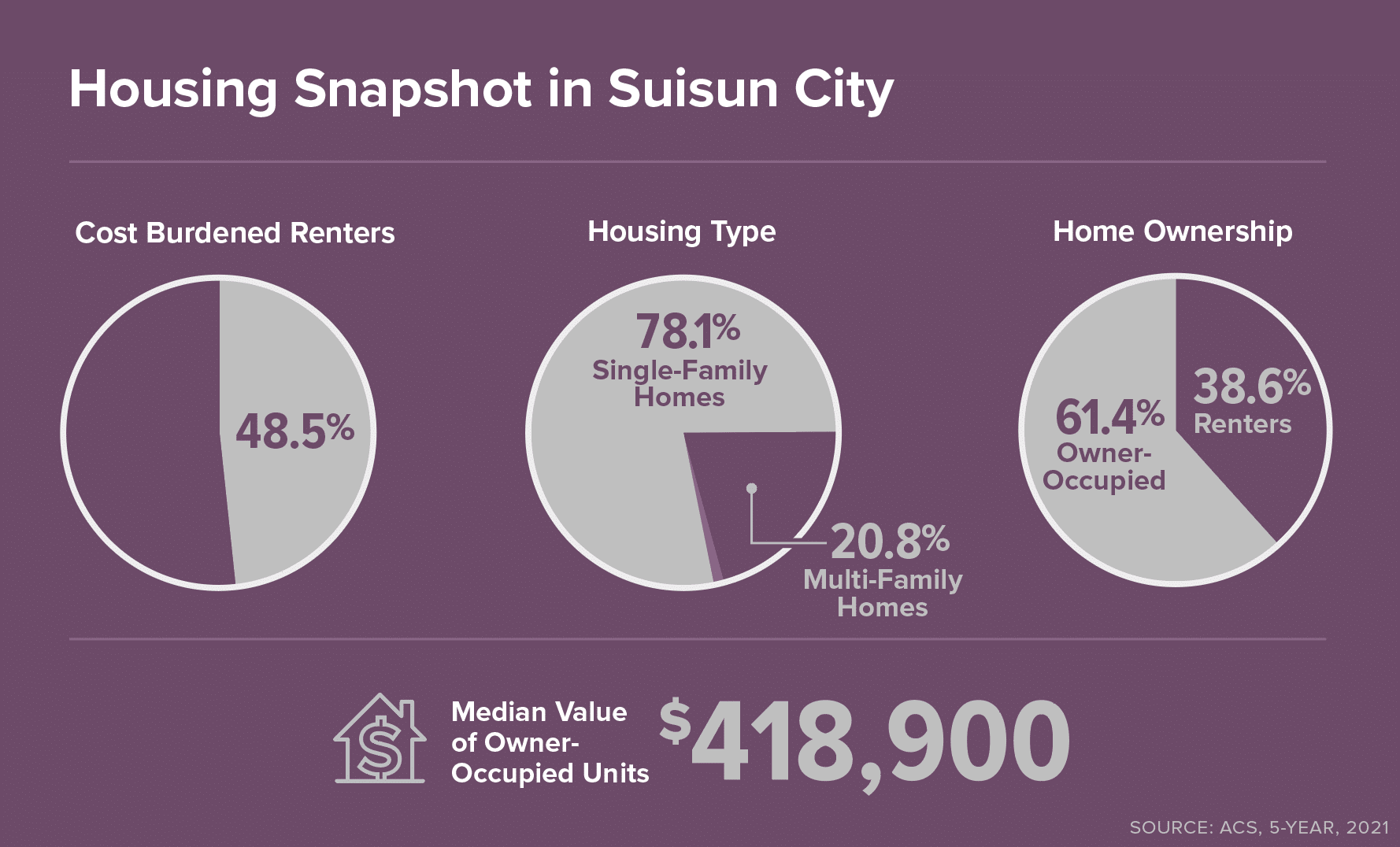
In Suisun, there are 3,376 households that qualify as low income (36.5%), 11.6% of people report not speaking English “very well,” and 48.45% of renters are cost burdened—all of which can make adapting to and recovering from climate shocks extremely difficult and inequitable.

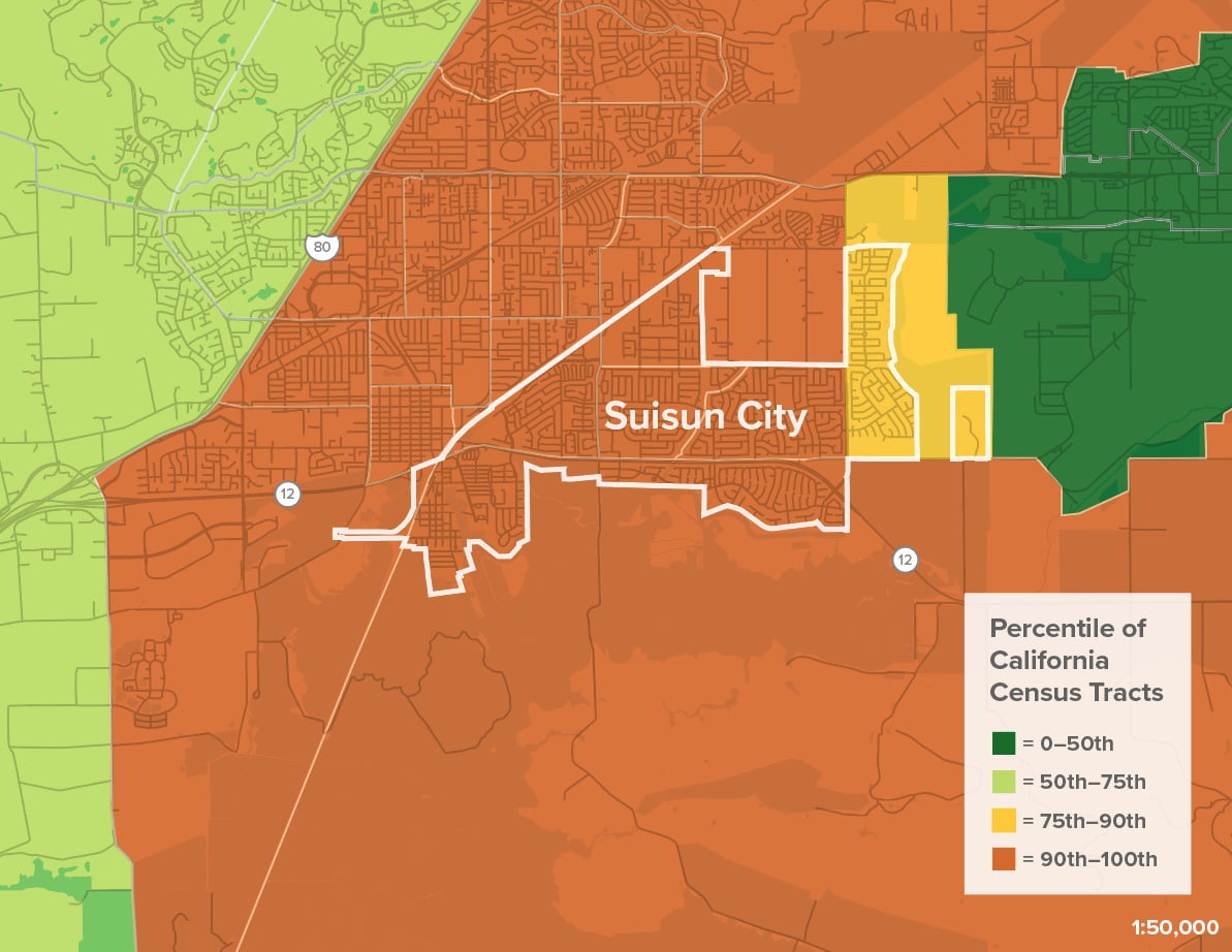
Social Vulnerability and Sea Level Rise
1. Community Vulnerability
2. With 108” of SLR

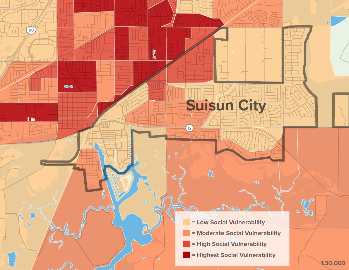
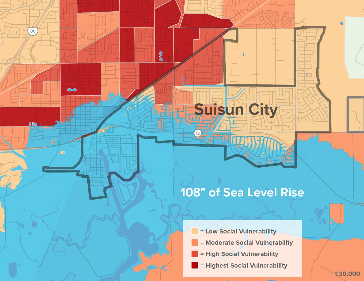
Suisun City’s resilience actions will not only impact its residents but will also have huge impacts on neighboring Fairfield residents. Both communities will in turn experience housing price shocks, disruptions to transit services, and lack of access to schools and essential services

Map citations:

Bay Conservation and Development Commission (BCDC). 2020. “Community Vulnerability.” Accessed June 20, 2023.

Adapting to Rising Tides: Bay Conservation and Development Commission (BCDC). 2020. “ART Bay Area Sea Level Rise and Shoreline Analysis Maps.” Accessed June 2, 2023.

Wildfire

In addition to threats of sea level rise, wildfire risk is a growing concern for local residents who have experienced two recent brush fires in shoreline areas—the Nurse fire in 2019 that burned over 1,500 acres and the Wildlife fire in 2020 that burned 300 acres and impacted multiple neighboring homes.

Fire Risk in Suisun City

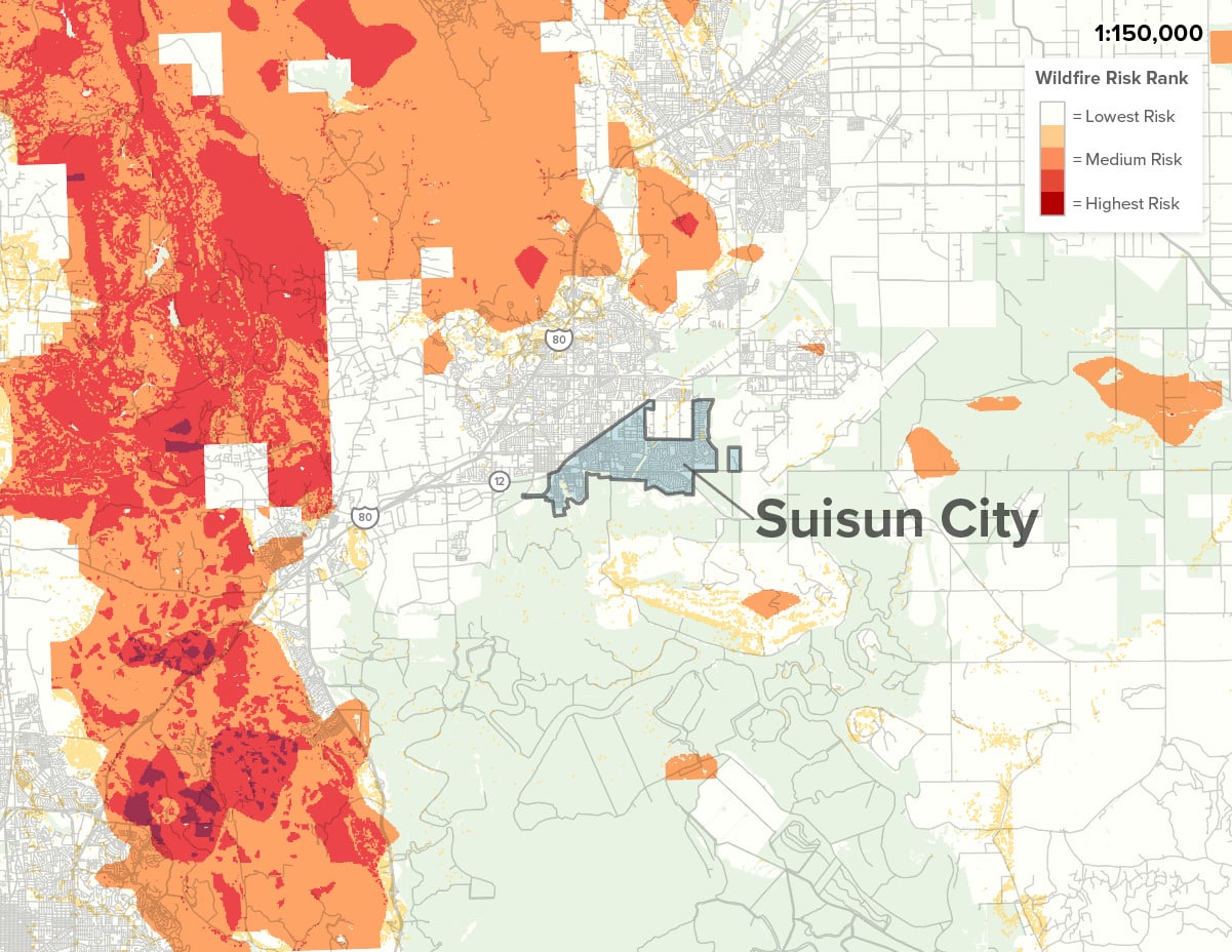
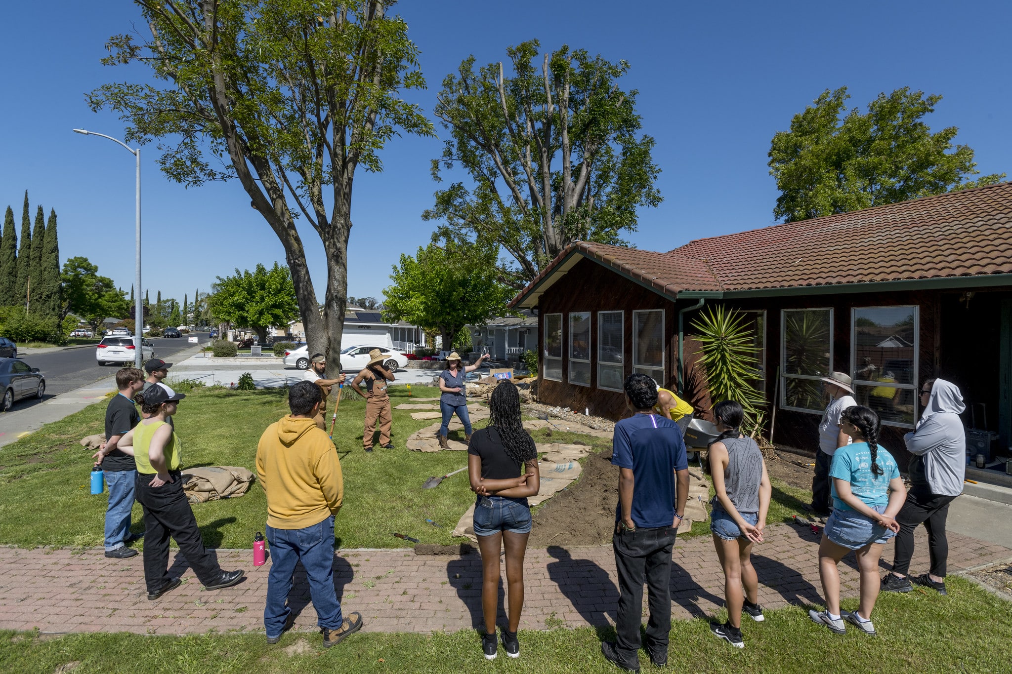
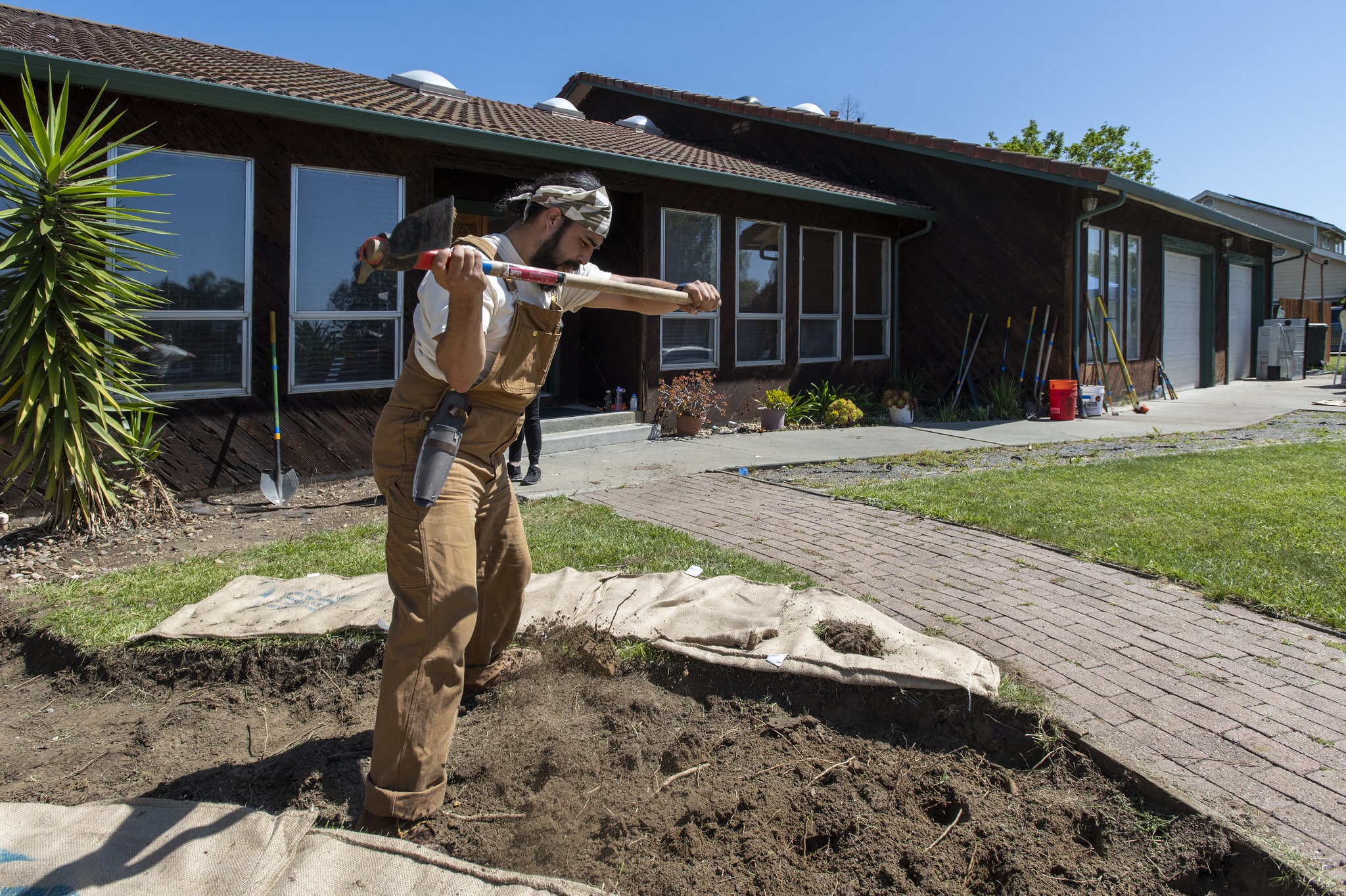
The recent fire events in Suisun are a powerful lesson in the importance of vegetation maintenance. Several of Suisun’s shoreline areas that are predominantly marshlands have been identified as fire hazard zones.

The 2020 Wildlife fire traumatized nearby residents when a brushfire erupted in an unmaintained area buffering a Suisun neighborhood from the Marsh. In the aftermath, surveyed residents ranked wildfire danger above all other climate threats as a top priority. The Fairfield Suisun Sewer District is currently leading a project to mitigate both flooding and wildfire risks at the site of the fire—learn more here.

Map citation:

Greenbelt Alliance. 2022. “Hotspots Fire Map.”

Conservation
& Sprawl

Suisun City’s location at the mouth of the Delta, adjacent to the Suisun Marsh, the largest contiguous brackish water marsh on the West Coast, makes it a unique place and a high priority for the Bay’s health. The Marsh provides refuge for thousands of waterfowl migrating on the Pacific Flyway and provides essential habitat for more than 221 bird species, 45 mammal species, 16 different reptilian and amphibian species, and more than 40 fish species. Sea level rise and increasing salinity pose the risk of wetland loss and degradation, which will impact the Marsh’s ability to support a thriving ecosystem.

Opportunities for Nature-Based Solutions

Suisun City’s health and safety is closely interrelated with the health and vibrancy of its bayshore habitats and wetland resources. Protecting, restoring, and stewarding Suisun Marsh and neighboring habitats can bolster long-term resilience while offering vital co-benefits to ecosystems and communities.

Suisun’s Waterfront District and City Hall are located on historic tidal marshlands and are at risk of flooding.

The majority of the historic marshlands are still intact, but without protection and management, these ecosystems will be inundated and no longer able to function as habitat and flood protection resources.

Native plants and waterfowl, such as the rare Suisun Thistle and Suisun Song Sparrow, still inhabit the Marsh, but increasing salinity from sea level rise will threaten these species if there is no room for them to migrate inwards as the water level increases.

San Francisco Estuary Institute’s (SFEI) Adaptation Atlas has identified multiple options for Nature-based Solutions to bolster the resilience of Suisun and the Marsh. As seen in the Adaptation Atlas’s recommended nature-based solutions, a combination of Living Levees, migration space for wetlands, and polders—reclaimed areas of land surrounded by dikes that are used for managing water levels—would have multiple benefits for resilience.

Recommended Nature-Based Solutions in Suisun City

Map Citations:

SFEI Adaptation Atlas: San Francisco Estuary Institute (SFEI). 2019. “San Francisco Bay Shoreline Adaptation Atlas GIS data, Version 3.” Accessed June 1, 2023. http://www.sfei.org/data/adaptation-atlas-data.

Sprawl Risk & Unprotected Lands

Several shoreline sites are essential to the region’s conservation goals, yet they remain unprotected from development.

Essential and Important Lands for Conservation Goals and Sprawl Risk
1. Essential Lands for Conservation Goals
2. Sprawl Risk

Suisun’s natural lands are highly vulnerable to sea level rise and flood impacts and may be prime locations to allow for Wetland Migration to move inwards. As water levels rise, areas adjacent to wetlands can be managed to become wetlands themselves.

However, the protection of shoreline sites and the development of nature-based solutions cannot occur only on the fringes where nature abuts development. It is important to consider the extended landscape so that an adaptation project does not have unintended consequences, especially beyond its geographic scope. Nature-based solutions must also account for marshlands distant from development and how they will adapt to increasing water levels and salinity while addressing management of runoff before it reaches the marsh. 

The health and sustainable management of the Suisun Marsh is key to the success of nature-based projects. But Suisun Marsh lacks the extensive development of other parts of the San Francisco Estuary, primarily because Solano County lacks the economic resources compared to other Bay Area counties.

With the exception of Grizzly Island and Rush Ranch, roughly 80% of the Marsh is privately owned by duck-clubs. The Suisun Resource Conservation District (Suisun RCD) must consult private landowners on how to manage the wetlands. 

Map Citations

Conservation Land Network: Together Bay Area.”Full CLN 2.0 GIS Database (Version 2.0.1).” Accessed July 12, 2023. https://www.bayarealands.org/maps-data/#maps.

Greenbelt Alliance. 2017. “At-Risk 2017 GIS Data.” Accessed February 20, 2023. https://www.greenbelt.org/at-risk-2017-gis-data/.

Social &
Health

Suisun and neighboring Fairfield share development patterns, demographic factors, and environmental conditions. Both cities face housing and transportation challenges resulting in community health problems. A lack of affordable housing options in the region has created economic insecurities and a reliance on cars. Additionally, these communities are positioned near truck routes and other pollutants. As a result, Suisun and Fairfield experience some of the highest asthma rates in the state.  

Housing

Suisun is regarded as a relatively affordable location in the Bay Area, but the region’s high cost of living and limited housing supply leads to many residents here becoming rent burdened or housing insecure.

Suisun and Fairfield have experienced an influx of people moving from other Bay Area cities as those cities have become more expensive. Urban Displacement Project data shows that many communities in Fairfield and Suisun are “Low-income/Susceptible to Displacement,” which is corroborated by data indicating that nearly 50% of renters in Suisun are cost-burdened.

While Suisun City has limited available sites for climate SMART housing development, neighboring Fairfield has the opportunity to build Infill Development housing that will be critical in the future as people are displaced from shoreline locations due to climate hazards like flooding.

Suisun City and Fairfield can reduce harm and economic losses by planning together for the future. As part of this process, unhoused residents must be factored into these conversations. Many of the area’s unhoused people will be hit first and worst by the impacts of climate change. Creating more housing, and specifically more affordable housing, is one essential next step, but another is creating plans for flood events and climate emergencies that ensure all residents are safe and informed about where to seek assistance.

Transportation & Jobs

Suisun City experiences high levels of car dependency and a lack of public transit options, as well as limited safe options for bikes and pedestrians.

Suisun City is largely a “bedroom community.” In other words, nearly 80% of residents commute out of the city for work. Many commute to neighboring Fairfield, but nearly 40% commute over 25 miles to work (U.S. Census). Studies show that people who commute long distances and have limited transportation options often feel climate shocks more acutely since a flooded road or disruption to transit service can translate into missing work or not being able to access vital services.

Additionally, FAST Transit, the transportation agency serving local routes in Fairfield and Suisun, discontinued the only fixed-route bus line in Suisun City during the pandemic and offers limited alternative transit services. Currently, the only high-quality transit stops are at the Amtrak Station, with none serving the area North of Highway 12 in Suisun (CA HQ Transit Stops, Caltrans).

Suisun and Fairfield are served by Amtrak’s Capitol Corridor route, which acts as a dividing line between the cities and constitutes vital transportation infrastructure that will be impacted by flooding in the near future. Sea level rise projections of 3 feet would impact the Amtrak station itself. Rising groundwater increases the likelihood of liquefaction, which presents additional challenges for rail lines adjacent to the marsh.

Pollution Burden & Public Health

Air quality issues in Suisun City and Fairfield produce some of the highest asthma rates in the state. Policies to mitigate air pollution and promote urban greening are essential to combat this issue.

CalEnviroscreen Data (using percentile rank for all census tracts in California)
1. Cumulative Environmental Risk
2. Asthma
3. Hazardous Waste
4. Solid Waste

The city’s census tracts rank in the top 95th percentile for asthma in the state and the top 50th percentile for toxic releases (CalEnviroScreen 4.0 data).

Public health conditions are closely tied to development patterns and the availability of natural infrastructure. Populations with high rates of asthma and heart disease are more negatively impacted by extreme heat events in general and wildfire smoke in particular. To address these concerns, Suisun can adopt something similar to the community monitoring program that the neighboring city, Fairfield, is conducting as part of AB 617.

Additionally, Solano Land Trust has conducted a study with partners to understand prime areas for park and open space improvements that would advance youth health outcomes by aiming to create access to the outdoors for all Solano County youth.

Map citation:

California Office of Environmental Health Hazard Assessment (OEHHA). 2021. “CalEnviroScreen 4.0 GDB file.” Accessed June 16, 2023. https://oehha.ca.gov/calenviroscreen/report/calenviroscreen-40.

A Note on Fairfield & Suisun City

Fairfield and Suisun City share utility districts, schools, transit, and more. The two cities are closely intertwined in many ways; yet they are also vastly different. Climate risks don’t respect jurisdictional boundaries, and coordinated efforts across cities and regions have proven to be more effective in mitigating risk and achieving equitable outcomes. While we strive to tell Suisun’s story and support local efforts, we also acknowledge that future activities and planning studies cannot be limited to this city alone since the actions Suisun takes in the upcoming decades will have monumental impacts and potential on their neighbors in Fairfield.

Community Partners

Other Key Partners
& Leaders

Opportunities for Resilience

The following goals and recommended next steps have been informed by conversations and feedback from a variety of local stakeholders as well as a thorough review of past and ongoing documents and studies, with support from data analyses and land-use and planning expertise.

GOAL

Protect Suisun City and key assets from near-term flooding through a combination of living levees and Gray Infrastructure.

NEXT STEPS

Secure funding to prepare an Adaptation Plan and identify shovel-ready projects to protect the city’s assets and communities.

Identify funding sources and governance strategies to maintain green infrastructure and vegetation to mitigate possible fire risk and public safety concerns.

GOAL

Develop a long-term community vision and corresponding strategies for living with water.

NEXT STEPS

Conduct a visioning process involving Fairfield, Solano County, public agencies, community partners, and the public to create a vision for Suisun and the immediate region that is founded in science. 

Identify strategies for long-term resilience that are supported by near-term protective strategies. Use adaptation pathways as a decision-support framework to identify thresholds, triggers, and decision points to guide action implementation.

Investigate the risks of shallow groundwater and integrate them into long-term resilience strategies.

Support capacity-expanding partnerships among government and local environmental organizations to build resources for Climate Resilience initiatives and implementation.


GOAL

Build public awareness and support for nature-based flood resilience strategies.

NEXT STEPS

Communicate Suisun’s story through creative media that engages historically marginalized and underrepresented communities, including youth.

Partner with Sustainable Solano to lead flood walks, workshops, and events to build awareness.

Identify additional partners, community leaders, and rooted organizations to expand the reach of engagement opportunities, with a focus on historically marginalized communities.

Barriers to Action

  1. As a small city, Suisun has limited resources and capacity for climate resilience planning, which is strained further when having to compete with larger cities that often have more capacity to apply for funding and resources. 
  2. The City, its Climate and Environment Committee, and Sustainable Solano have made major strides in building awareness for flood risks. However, there is still a need to reach more community members to build support for action to mitigate those risks. 
  3. Suisun City shares a border, a school district, sewer infrastructure, and many families and resources with its neighbor, Fairfield. When it comes to flood resilience, Suisun’s actions will directly impact Fairfield, which has key properties and assets located in areas likely to be inundated by 2100. A coordinated planning effort is vital to ensure the future resilience of both communities. Working across jurisdictions can present challenges that slow down critical next steps needed to build resilience. 

Suisun City Actions & Updates

Flood Walk

On August 31, Greenbelt Alliance led a Flood Walk with Sustainable Solano. Over thirty participants came to learn about the challenges presented by sea level rise in Suisun City and what can be done to address it. We are planning another flood walk for January 2024 in Suisun—sign up for our newsletter to stay tuned.

SUBSCRIBE TO OUR NEWSLETTER
Sign on to Support Sea Level Rise Mitigation in Suisun

Show support for the City Council to further adaptation efforts by using the findings from Community Resilience Building Workshop.

TAKE ACTION
Solano Bayshore Resiliency Roundtable

The Solano Bayshore Resiliency Roundtable has continued to meet every month “to foster resilient projects and citizen engagement for our communities and our environment through our shared values, joint initiatives, and coordinated efforts.”

LEARN MORE
Fighting Sprawl in Eastern Solano County

Greenbelt Alliance is a part of the Solano Together Coalition, a group of concerned residents, leaders, and organizations that envisions a better future for the region. Solano Together will provide the public, voters, and decision-makers with accurate information on the impacts of California Forever and unite around a shared vision for the future.


LEARN MORE
Scroll to Top