What Makes Gilroy a Hotspot?

Gilroy faces significant climate risks including fire, flooding, and extreme heat. Severe flooding and wildfires have historically and recently caused serious property damage and economic challenges for local residents—a community that is also grappling with health issues caused by rising temperatures. 

Quick Data

TOTAL Population: 58,802

Population by Race

Cost Burdened Renters

History

TIME IMMEMORIAL

Gilroy was first inhabited by the Ohlone people, part of the Mutsun Nation, which at one time comprised some 22 Central Coast tribes (City of Gilroy Website).

1850

The area known as Gilroy was colonized by European settlers, and soon after an agricultural boom brought crops such as grain, fruit, and vegetables to the fertile region.

1869

The arrival of the railroad boosted Gilroy’s local economy and facilitated trade.

EARLY 20TH CENTURY

Gilroy experienced a period of growth and expansion with the establishment of several new industries, including the production of canned fruits and vegetables, as well as the development of new housing and commercial areas.

1922

The Gilroy Garlic Festival began, celebrating the city’s garlic heritage, which became an annual tradition.

1937 – 1969

Multiple major floods occurred in Gilroy.

1980

A levee was implemented using government funding to protect the region against flooding.

2012

Gilroy adopted its first-ever Climate Action Plan, with a focus on decarbonization and improving local air quality. Full implementation has not yet been achieved.

2016

Through the work of local nonprofits and a community-led coalition, Gilroy established its first Urban Growth Boundary via the successful Measure H campaign.

2020

The Crews Fire in July and the SCU Lightning Fires in August tore through Southern Santa Clara County, forcing evacuations and causing displacement in parts of Gilroy.

2023

During the winter, converging storm systems caused Uvas Creek to flood surrounding areas. The floods forced the closure of Highway 101 and impacted Gilroy homes and businesses, particularly among low-income communities in the southernmost areas of the city.

PRESENT

Gilroy continues to grow with new industries such as technology and healthcare becoming important economic drivers.

Climate Vulnerabilities

Gilroy has struggled with flooding due to its Valley location and confluence of rivers for decades. But climate change has made storms more severe and decades of development have increased run-offtogether resulting in disastrous floods such as the ones Gilroy experienced in January 2023 when Highway 101 was shut down for days. On top of flooding, Gilroy experiences some of the highest extreme heat risk in the county, and nearly 30% of the city is in a wildfire zone, presenting direct risk to residents and property and indirect impacts as a result of smoke and shocks to the region’s agriculture industry.

Flooding

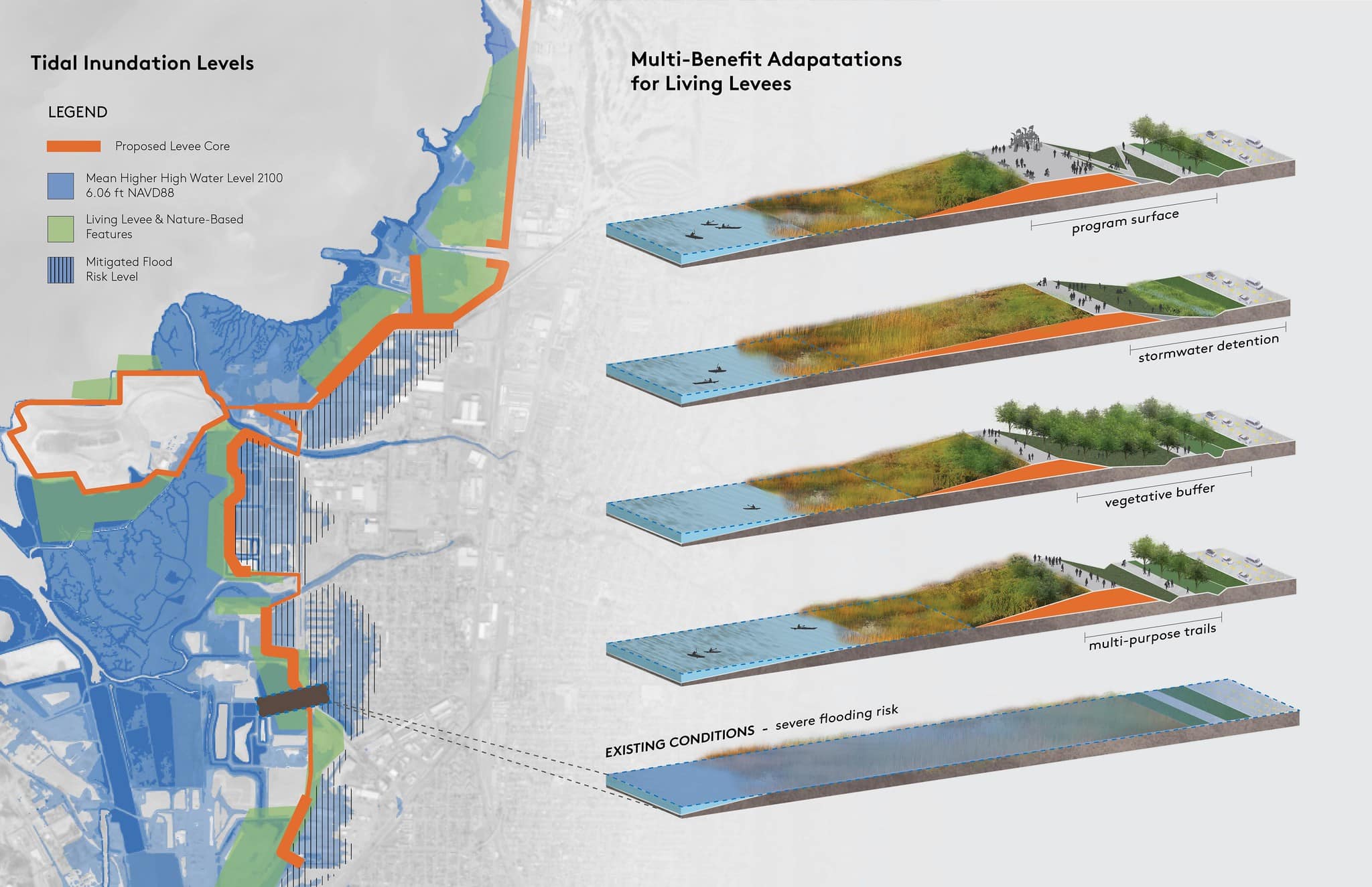
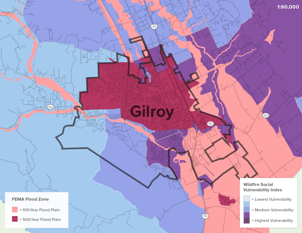
Almost the entirety of Gilroy is in a FEMA 100-year or 500-year flood zone, and recurrent flood events—particularly concentrated in south Gilroy’s lower income areas—cause physical, social, and economic damage to the city’s assets and communities.
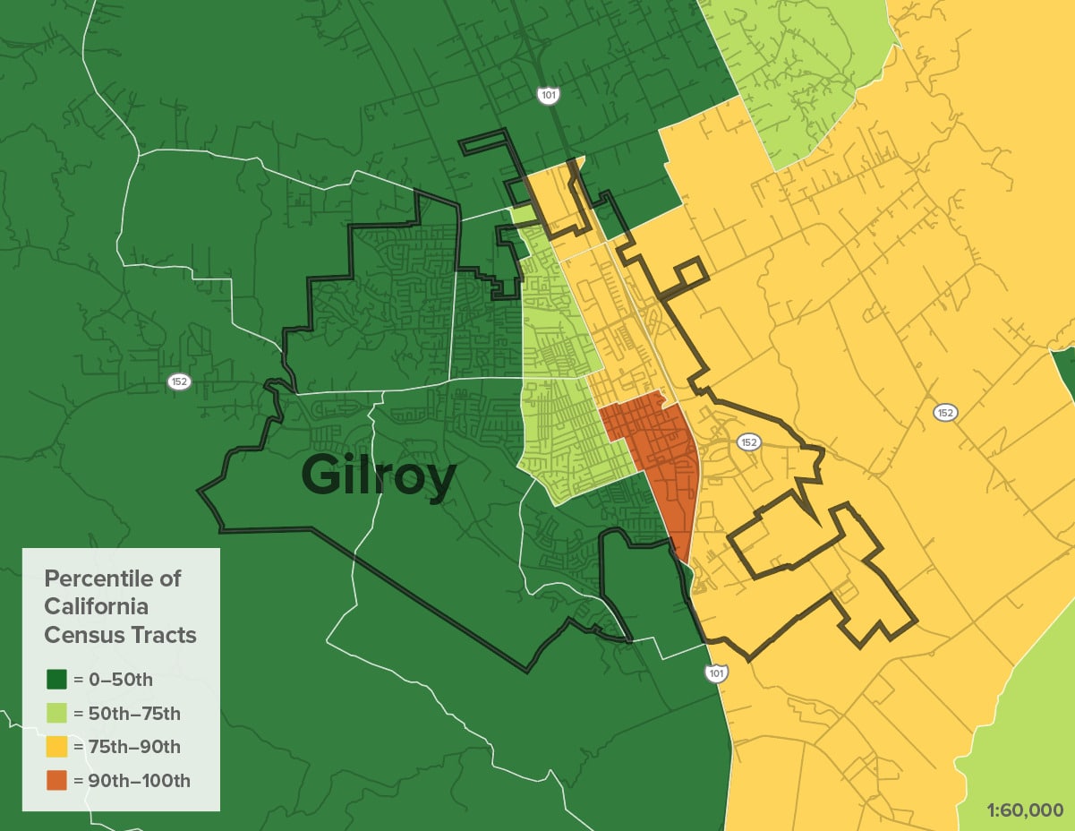
Flood Risk

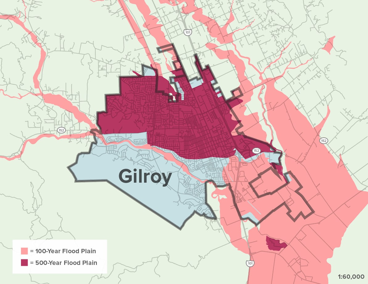
Gilroy’s valley is at the convergence point for multiple watersheds and creeks that have experienced repetitive flood events as a result of heavy rainfall.

Climate change will result in more frequent and more severe storm events. Many properties are bound to be impacted within the 500-year flood zone.

Map Citations:

Federal Emergency Management Agency (FEMA). 2009. “National Flood Hazard Layer: Santa Clara County.” Accessed July 6, 2023.
https://hazards-fema.maps.arcgis.com/apps/webappviewer/index.html?id=8b0adb51996444d4879338b5529aa9cd.
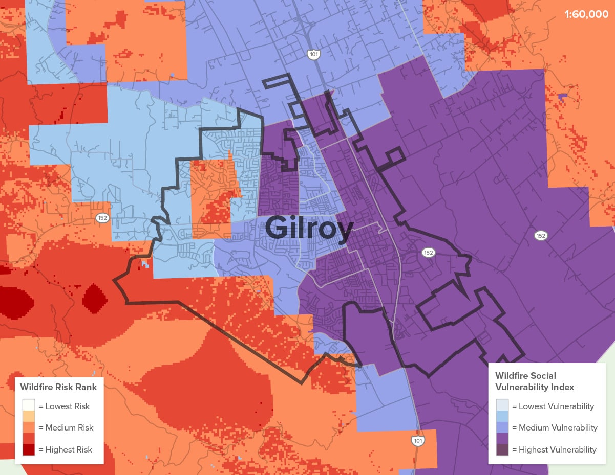
Wildfire

Approximately 28% of Gilroy is ranked as a moderate, high, or very high fire hazard. Areas immediately outside of the city limits, especially on the western and southern sides, are highly vulnerable to wildfire as well.
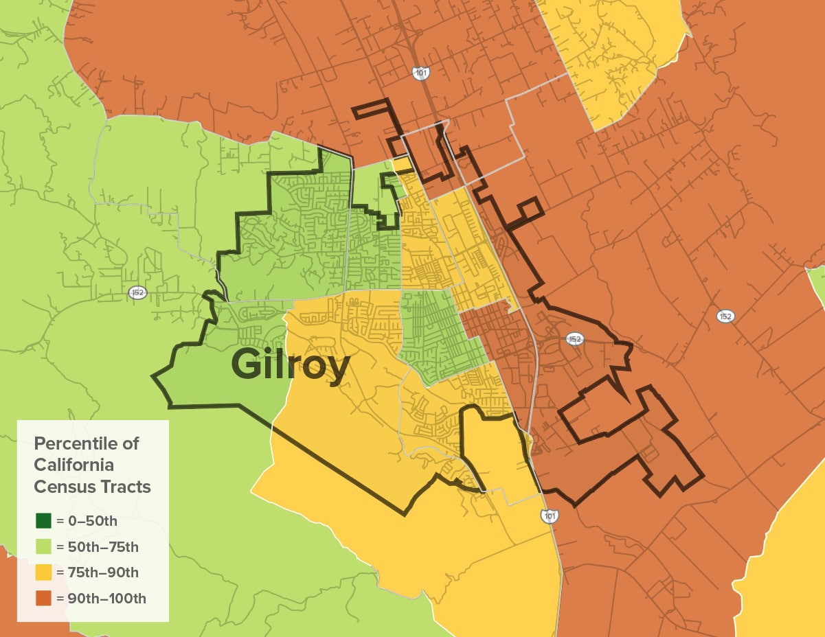
Wildfire Risk


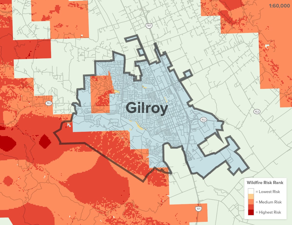
Gilroy’s close proximity to the Santa Cruz Mountains and Diablo Range exposes the city to high direct and indirect wildfire danger. Multiple fires (Hummingbird, 2008; Bally, 2017; Crews, 2020) in Gilroy over the past decade have forced evacuations, destroyed homes and businesses, and exposed residents and outdoor workers to harmful smoke impacts. Even when fires haven’t resulted in direct physical damage to structures or displacement of residents, the fires have had grave impacts on the farmworker community who lack the employment protections necessary to allow them to retreat from the fields on days when air quality is poor as a result of wildfire smoke.

Citation:

Greenbelt Alliance. 2022. “Hotspots Fire Map.”

Extreme Heat

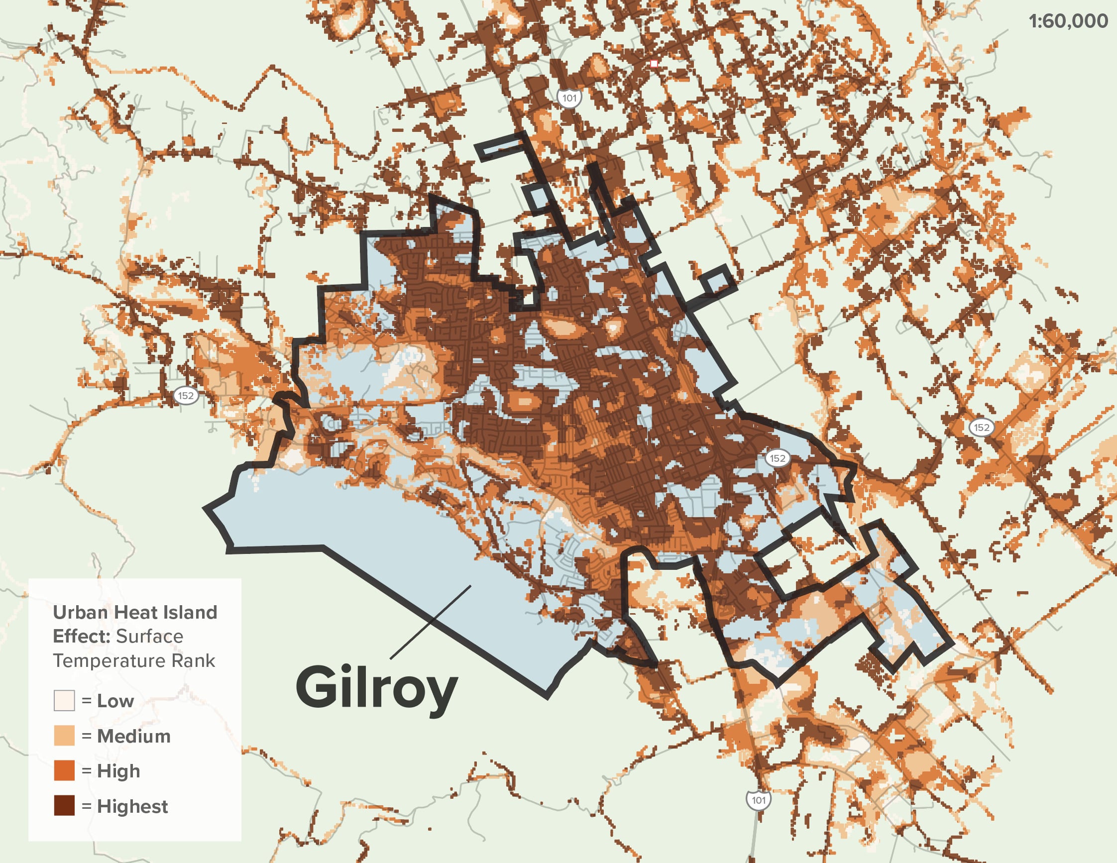
Gilroy’s lack of green space and tree canopy, in addition to poor housing conditions and existing public health issues, contribute to some of the most critical heat issues in Santa Clara County.

Gilroy’s impermeable surfaces and lack of tree cover exacerbate extreme heat by creating an urban Heat Island effect that makes the area dangerously warmer than the surrounding countryside, worsening health outcomes. Roughly 42% of Gilroy residents cannot access a park within a 10-minute walk (TPL), which is a concern not only during heat events, but also for the long-term mental and physical well-being of Gilroy youth and families.

Temperatures often reach past 100 degrees in the summer, and Gilroy has seen heat records shattered multiple times in the past decade.

As with wildfire smoke, extreme heat disproportionately affects low-income communities and people of color as a result of their specific working conditions and their lack of access to amenities like air conditioning and local heat refuges.
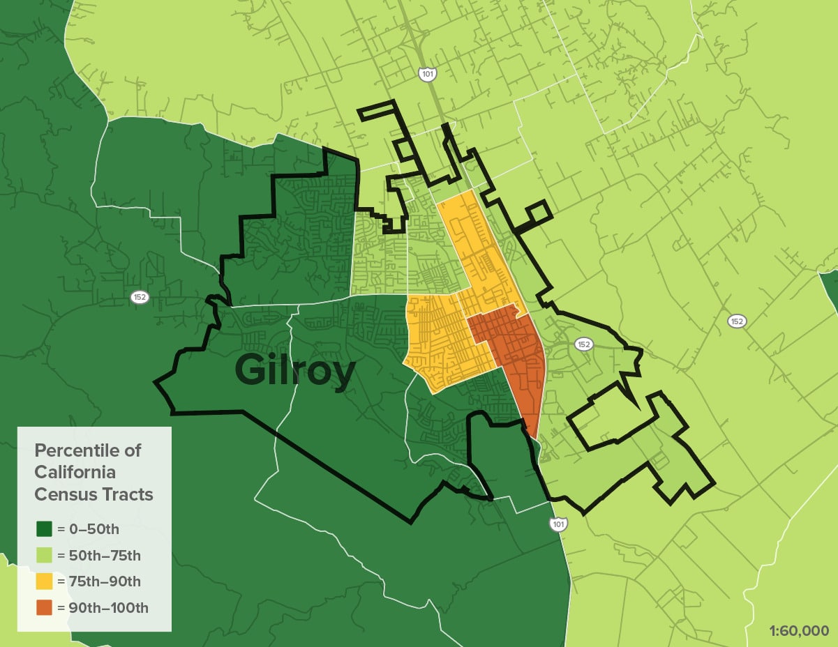
Extreme Heat

Heat events are one of the deadliest climate hazards. Small children, the elderly, people with certain chronic diseases, low-income populations, and outdoor workers are at higher risk of heat-related illness (CDC). 

In Santa Clara County, there were 150 heat days between 2009 – 2018, and 2,610 ER visits due to extreme heat in Gilroy alone. This averages to 261 visits per year for heat-related illnesses in Gilroy. 

Map Citations:

UC Berkeley Urban Heat Island Effect Map. 2010. “2010 Surface Temperature: Regional Quintile”

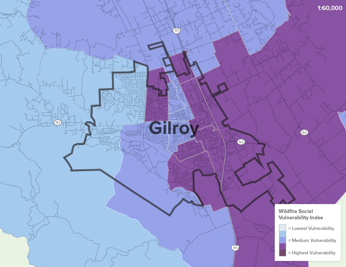
Social Vulnerabilities

Gilroy’s multiple climate hazards will disproportionately impact the city’s low-income, cost-burdened, and Latinx communities.

Intersecting Vulnerabilities
1. Wildfire Social Vulnerability Index
2. With Wildfire Risk Rank
3. With FEMA Flood Zone

Gilroy’s Spanish-speaking communities are largely reliant on the agricultural industry. Changes in temperature, precipitation, and growing seasons can affect crop yields and livelihoods for farmers and those who are dependent on the agricultural economy.

Rising temperatures and heat waves have disproportionate health impacts on vulnerable populations like the elderly, the immunocompromised, unhoused individuals, and low-income people without access to cooling resources.

Additionally, wildfires can have severe impacts on public health and damage property and critical infrastructure, putting more pressure on already cost-burdened and housing-insecure residents.

Map Citations:

Greenbelt Alliance. “Wildfire Social Vulnerability Index.” 2022
Greenbelt Alliance. “Hotspots Fire Map.” 2022.
Federal Emergency Management Agency (FEMA). 2009. “National Flood Hazard Layer: Santa Clara County.” Accessed July 6, 2023. https://hazards-fema.maps.arcgis.com/apps/webappviewer/index.html?id=8b0adb51996444d4879338b5529aa9cd

Conservation
& Sprawl

Gilroy’s location at the edge of Santa Clara County along the Highway 101 corridor and in between two large landscape blocks has resulted in high sprawl development that threatens vital farmland and lands that are critical for conservation goals.

Sprawl Risk & Unprotected Lands

Decades of sprawling development in Gilroy has resulted in a lack of permeable surfaces, worsening urban heat islands, significant and growing infrastructure maintenance needs, and lack of open space—all while increasing Vehicle Miles Traveled and air pollution.

Essential and Important Lands for Conservation Goals and Sprawl Risk
1. Conservation Land Network
2. Sprawl Risk

Within the city of Gilroy, there is particular risk of sprawl along Uvas Creek, which is also an essential area for conservation purposes due to its linkage to the Santa Cruz Mountains. In northern parts of Gilroy and immediately outside the city to the east, significant farmland is at risk of development as well.

The pressure to develop land has grown in the region as Gilroy and neighboring communities have transitioned from a primarily agricultural economy to one anchored in Light Industry and warehousing.

Sprawl development in Gilroy will put more people and assets in High Fire Hazard Severity Zones while also exacerbating flood risks and heat impacts.

Map Citations:

Conservation Land Network: Together Bay Area.”Full CLN 2.0 GIS Database (Version 2.0.1)” Accessed July 12, 2023. https://www.bayarealands.org/maps-data/#maps.
Greenbelt Alliance. 2017. “At-Risk 2017 GIS Data.” Accessed February 20, 2023. https://www.greenbelt.org/at-risk-2017-gis-data/.

Landscape Linkages & Critical Habitat

Gilroy’s location between the Santa Cruz and Diablo ranges means that the lands immediately surrounding the city have rich biodiversity that must be protected.

Regional Connectivity Gilroy

The Santa Cruz Range immediately to the southwest of Gilroy is known for its rich biodiversity. The range is home to various oak woodlands, mixed evergreen forests, and chaparral ecosystems. It provides habitat for numerous wildlife species, including mountain lions, bobcats, black-tailed deer, California red-legged frogs, and various bird species.

South of Gilroy, a vital wildlife linkage is currently hindered by three highway barriers. Connecting these two large landscape blocks is critical for preserving species diversity, especially as many native species like coast live oak and coho salmon are experiencing habitat disruptions as a direct result of climate change. Rising temperatures can result in shifts in suitable habitat for plants and animals, impacting their distribution and survival.

Gilroy’s open lands are critical to the protection of the Bay Area’s flora and fauna. They are also vital for our water quality and forest health—especially in the face of rising wildfire risk.

Map Citations:

Conservation Land Network: Together Bay Area.”Full CLN 2.0 GIS Database (Version 2.0.1).” Accessed July 12, 2023. https://www.bayarealands.org/maps-data/#maps

Social &
Health

Gilroy’s climate threats are not evenly distributed around the city. Non-white and low-income residents are currently on the frontlines of climate change in Gilroy due to patterns of segregation reinforced by planning and policy decisions. The communities located near Highway 101 and east of Monterey Highway experience severe housing cost pressure, climate risks, and pollution burdens, while Gilroy’s western areas are predominantly white and face very different conditions.

Housing

While the region has a high rate of home ownership, 35% of Gilroy residents are renters and 50% of these renters are cost burdened. Many of these cost-burdened households are clustered between the railroad and Highway 101, where there is also the highest Hispanic population in the region (as defined by the US Census).


Gilroy’s communities are disproportionately vulnerable to increases in housing prices, climate shocks, and other disruptions compared to those living in other regions in Santa Clara County.

While Santa Clara County’s average household size is 3.0 people per household, Gilroy’s average is 3.5. Gilroy has twice as many households with 5 or more people living in one home as the county overall, 24% to the county’s 12% (Housing Element).

As a result of regional housing pressure, these communities also face displacement pressure due to Gilroy’s location close to Silicon Valley and other nearby amenities. Cost pressures have resulted in housing overcrowding and the proliferation of multi-generational households.

Gilroy has twice as many households that experience overcrowding as compared to the county overall and an average household size of 3.5 compared to the County’s 3.0 (Housing Element).

Gilroy has been the center of numerous housing disputes that balance housing demands with the impact of development on specific locations. As part of the recent Housing Element update, the City planned for how they would accommodate 1,773 new units over the next 10 years, over half of which are set to serve low and very low-income households (Housing Element).

Pollution Burden & Public Health

Gilroy, especially East Gilroy, experiences some of the highest environmental risks and contaminants in the state.

CalEnviroscreen and Indicators in Gilroy
1. Cumulative Environmental Risk
2. Pesticide Exposure
3. Low Education Attainment

Most census tracts in Gilroy are in the highest 70th percentile of tracts for CalEnviroScreen measures of multiple sources of pollution, with one tract as high as the 93rd percentile. High rates of Diesel Particulate Matter and other pollutants from truck and highway traffic have resulted in high asthma rates and high rates of cardiovascular disease.

Gilroy ranks in the 96th percentile of pesticide exposure. Pesticide exposure can produce immediate illness or lead to potential birth defects or cancer later in life.

Gilroy also ranks in the top 75th percentile for groundwater threats, which are probably related to the high pesticide exposure in the area.

Citation:

California Office of Environmental Health Hazard Assessment (OEHHA). 2021. “CalEnviroScreen 4.0 GDB file.” Accessed June 16, 2023. https://oehha.ca.gov/calenviroscreen/report/calenviroscreen-40.

Community Partners

Other Key Partners
& Leaders

Opportunities for Resilience

The following goals and recommended next steps have been informed by conversations and feedback from a variety of local stakeholders as well as a thorough review of past and ongoing documents and studies, with support from data analyses and land-use and planning expertise. 

GOAL

Partner with and engage with the large and growing Latinx community, youth populations, and permanent and seasonal farmworker communities.

NEXT STEPS

Understand climate risks and mitigation strategies through a comprehensive and regional plan that expands jurisdictional boundaries.

Engage the public in educational workshops and guided outings to build climate literacy around Nature-based Solutions and better understand local priorities and needs.

Partner with and engage chosen priority populations, including (1) the large and growing Latinx community, (2) youth populations, and (3) permanent and seasonal farmworker communities.

Collaborate with the Santa Clara Firesafe Council and the County to educate residents about risks and provide opportunities for meaningful input.


GOAL

Establish resilience hubs and cooling centers to provide heat refuge and community services.

STRATEGIES

Evaluate the potential of schools to act as refuge and resilience centers.

Collaborate with partners to secure resources to advance the establishment of a Gilroy or South County resilience hub that can provide heat refuge, smoke refuge, and emergency resources.

GOAL

Update city design to accommodate water through creek and river restoration and floodable infrastructure.

STRATEGY

Support the creation of an Adaptation Plan, Resilience Plan, and/or Climate Action Plan at the City level to comprehensively plan for resilience policies using green infrastructure.

GOAL

Protect and steward permeable land in and around the city, including open spaces and working lands.

STRATEGIES

Work with conservation partners to advocate for responsible, climate-smart development, uphold and renew Gilroy’s Urban Growth Boundary and support the conservation of lands that are critical for species movement and habitat.

Support Infill Development policies to ensure that vital natural and working lands are protected from development.

Barriers to Action

  1. Gilroy’s pre-disaster and resilience planning efforts are inadequate to the numerous and growing climate hazards facing the city. This is in part due to the city’s important competing priorities and limited resources.
  2. Gilroy is experiencing pressure from developers to build on precious open space lands—a direct result of Santa Clara County’s skyrocketing housing costs. Proposed housing developments by City planners and policymakers will further exacerbate climate risks by increasing runoff, expanding the Wildland-Urban Interface, and further disrupting natural Carbon Sinks like agricultural land and open space. 
  3. Climate hazards in the region, as in many places, have traditionally been researched and mitigated through siloed government agencies and processes, leading to inefficient and redundant strategies.

Gilroy Actions & Updates

In the Face Of Climate Change, Gilroy Comes Together For Resilience

The Forum For a Greener Future, presented by Greenbelt Alliance and the Community Agency for Resources, Advocacy and Services (CARAS), brought the Gilroy community together for a conversation on climate vulnerability and how to build resilience against climate impacts such as extreme heat.

READ MORE
Gilroy Hosted the Inaugural La Ofrenda Festival to Celebrate Arts and Wellness

At the end of October, Gilroy hosted a downtown event with over 80 booths to celebrate Dia de los Muertos and community wellness. The event included a community bike ride, free health screenings, and tons of artists and vendors. The event was put on by Santa Clara County, the City of Gilroy, and supported by many local organizations

READ MORE
Governor Signs Bill to Allow Valley Water to Serve Unhoused population

On October 10th Governor Newsom signed Assembly Bill 1469, which gives Valley Water the ability to use funds to support outreach, counseling, transitional housing, and other services to the county’s unhoused population.

FIND OUT MORE
Scroll to Top