What Makes Southwest Santa Rosa a Resilience Hotspot?

Southwest Santa Rosa is facing growing risks of wildfire and extreme heat. The region is home to innovative organizers and powerful social movements who address the region’s underlying inequalities for predominantly Latinx homeowners and farmworkers, who face the brunt of these rising climate impacts.

Quick Data

TOTAL Population: 38,072

Population by Race

Cost Burdened Renters

History

TIME IMMEMORIAL

The Santa Rosa plain is the ancestral home of the Hokan-speaking Bitakomtara (Pomo) Tribe. Neighboring tribes included the Wappo, Kashaya, and Northern Miwok. 

1833

The region known as Santa Rosa was colonized by Mexico.

1800s

Hundreds of Chinese immigrants built the railroad lines extending from Petaluma to Cloverdale. Sebastopol and Santa Rosa were home to robust Chinatowns despite widespread racism expressed by local papers, politicians, and militia.

1943-1964

The Bracero Program was created in response to labor shortages during WWII. The program recruited migrants from Mexico to work the fields in the United States, which included the vineyards and orchards of Sonoma County (PBS, 2019). 

1953

A small NAACP chapter was founded by Gilbert Gray, partially in response to Black migrants from the North and West who were being met with explicit racism and prohibited from buying property.

1954

The U.S. brought over 1 million Mexicans into the country, in response to a demand for cheap labor. This fueled racial tension and set a precedent for exploitative agricultural labor practices that continued long after the Bracero Program. 

1960

Civil rights hearings demonstrated rampant cases of housing and employment discrimination, segregation, and racism throughout Santa Rosa and Sonoma County, specifically against Black people. Roseland was one of the few neighborhoods that welcomed Black residents. 

1970s

Sonoma County’s most productive decade for home construction, with 22% of Sonoma County’s current housing stock produced in the 1970s (Generation Housing, 2022). Housing built between 1970–1990 accounts for over one-third of Santa Rosa’s housing stock. More housing was built in Santa Rosa between 1970 –1990 than in 1990 to the present.

1997

A Congressionally mandated study recommended the immediate restoration of three California tribes, including the Federated Indians of Graton Rancheria (descendants of the Southern Pomo and Coast Miwok).

2000

President Bill Clinton signed into law legislation restoring Federal recognition to the Federated Indians of Graton Rancheria. 

2017

Previously unincorporated, Roseland was annexed by the City of Santa Rosa.

2017

Throughout the month of October 2017, the Tubbs Fire claimed 22 lives, burnt over 36,000 acres, and destroyed over 5,000 structures, including 5% of Santa Rosa’s housing stock. 

2017

UndocuFund was launched in response to the Tubbs Fire to support undocumented and mixed-status residents who were ineligible for government aid. UndocuFund supported residents through fires in the subsequent years and reactivated during the Covid-19 pandemic. Since its inception, UndocuFund has distributed over $16 million.

2019

PG&E transmission lines ignited the Kincade Fire northeast of Geyserville on October 23, 2019. The fire was extinguished on November 6, 2019, after burning 77,758 acres and destroying 374 buildings. The fire caused widespread evacuations throughout Sonoma County, including Santa Rosa, as well as power outages that affected over 2 million residents.

2020

Lightning ignited 250 fires, known as the LNU Complex Fires, across six counties, including Sonoma County, that burned from August to October 2020. The fires caused 6 fatalities, burned 363,220 acres, and destroyed 1,491 structures. 

2020

The Glass Fire started on September 27, 2020, and burned for 23 days in Napa and Sonoma. The Glass Fire burned 67,484 acres and destroyed 1,555 buildings.

2021

The redistricting process that happens every 10 years brought the Roseland and Moorland neighborhoods into the same district as Santa Rosa (District 3). The process was criticized by members of the supervisor-appointed commission tasked with improving representation for marginalized communities. 

2022

The hottest-ever temperature was recorded in Santa Rosa at 115 degrees Fahrenheit (Press Democrat, 2022). Many residents without access to air conditioning or shelter sought refuge in local libraries and cooling centers.

2023

Multiple atmospheric rivers caused widespread flooding throughout Sonoma County. Road closures in Santa Rosa and throughout the county blocked transit, and rains put many farmworkers temporarily out of work during the winter pruning season.

PHOTO BY LOREM IPSUM

Climate Vulnerabilities

The size and severity of wildfires has increased across Sonoma County in recent years. Wildfire smoke, accompanied by an increase in extreme heat days have detrimentally impacted health outcomes for local residents—particularly for residents who work outside.

Extreme Heat

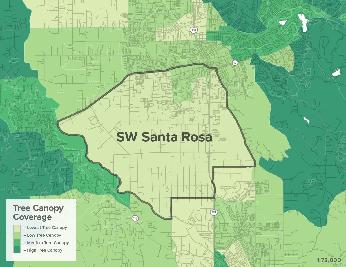
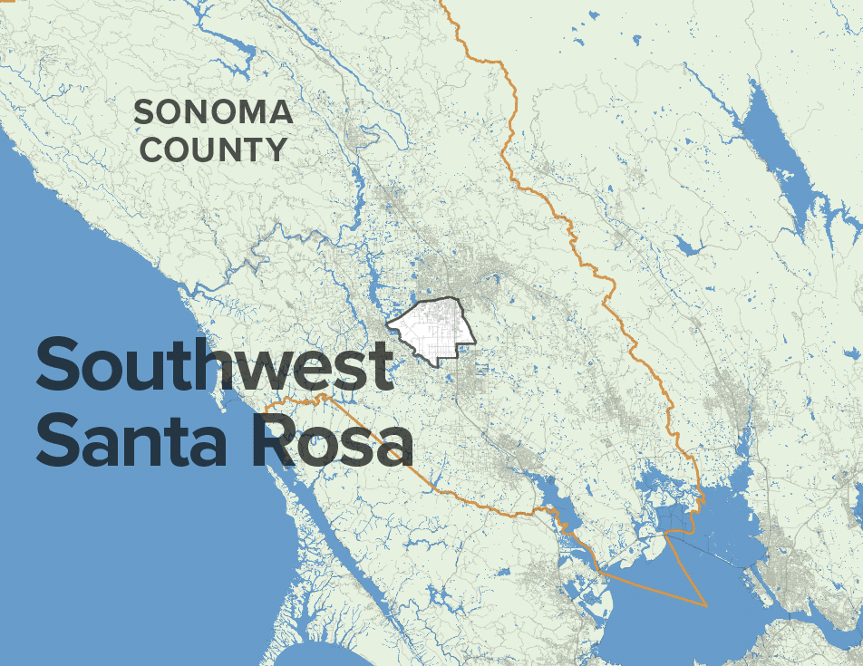
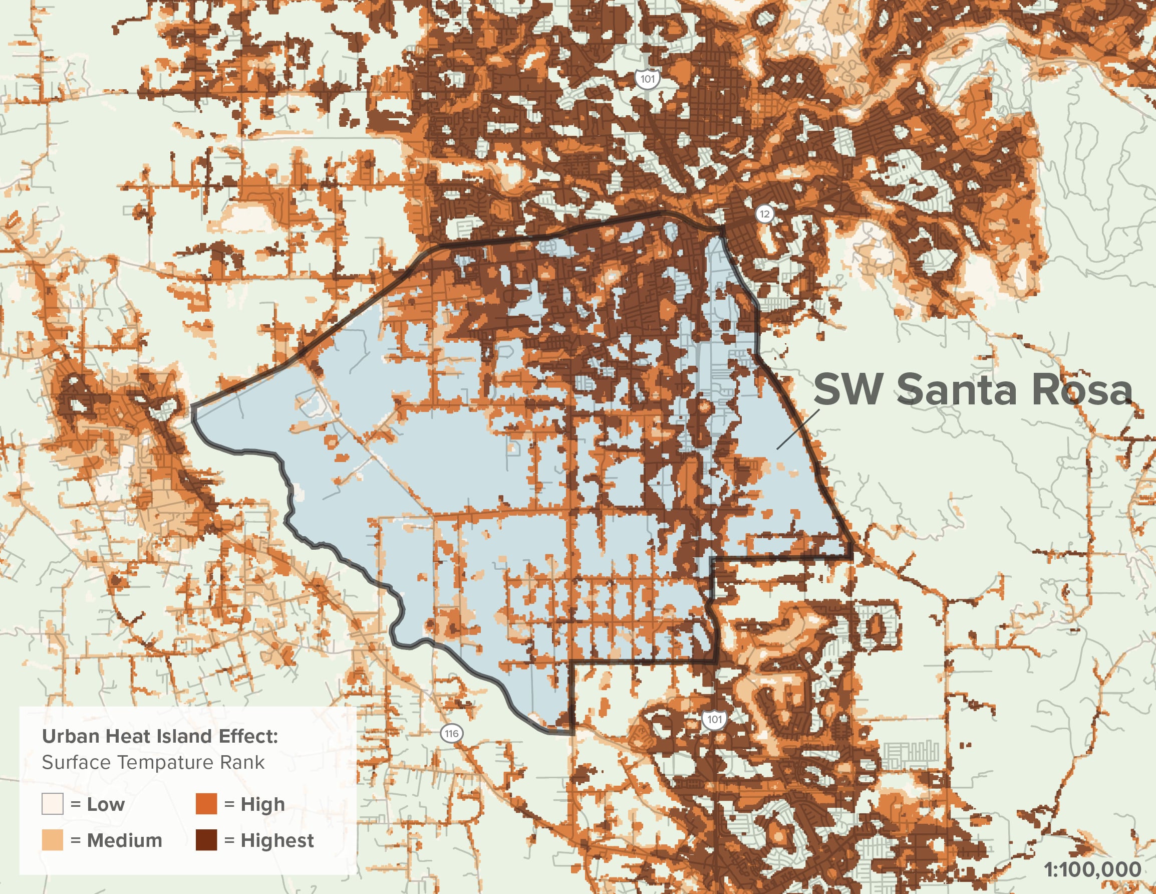
Southwest Santa Rosa will experience an increase of hot days and warm nights over the next century. In July 2022, the city broke records when a week-long heat wave reached temperatures around 115 degrees F. The region contains large areas of paved surfaces, sparse tree canopy, and fewer homes with air conditioning, making extreme heat days even more dangerous.
(U.S. Climate Resilience Toolkit).

Extreme Heat

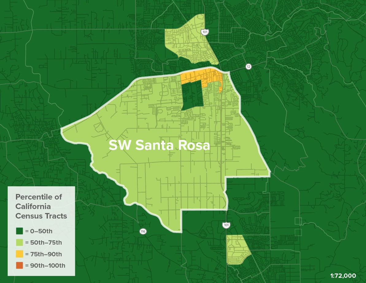
At the beginning of the 21st century, Southwest Santa Rosa experienced an average of 5 Extreme Heat days and 5 warm nights per year. Scientists estimate that the same region will experience an average of 14 extreme heat days and 38 warm nights per year by 2050 and 23 extreme heat days and 102 warm nights per year by 2100 (Cal Adapt High Scenario).

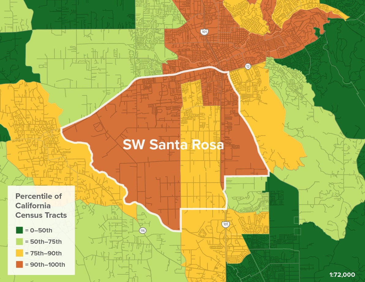
In urban environments, the “urban Heat Island” effect—disproportionate warming of an urban area because of buildings, pavement, and human activity—can increase temperatures from 1.8 to 5.4 degrees—a 200% increase.

Places experiencing urban heat islands often experience high indoor and nighttime temperatures that are strongly correlated with adverse health effects.

Even for those who can afford air conditioning, electricity can be out for hours or days during heat waves.

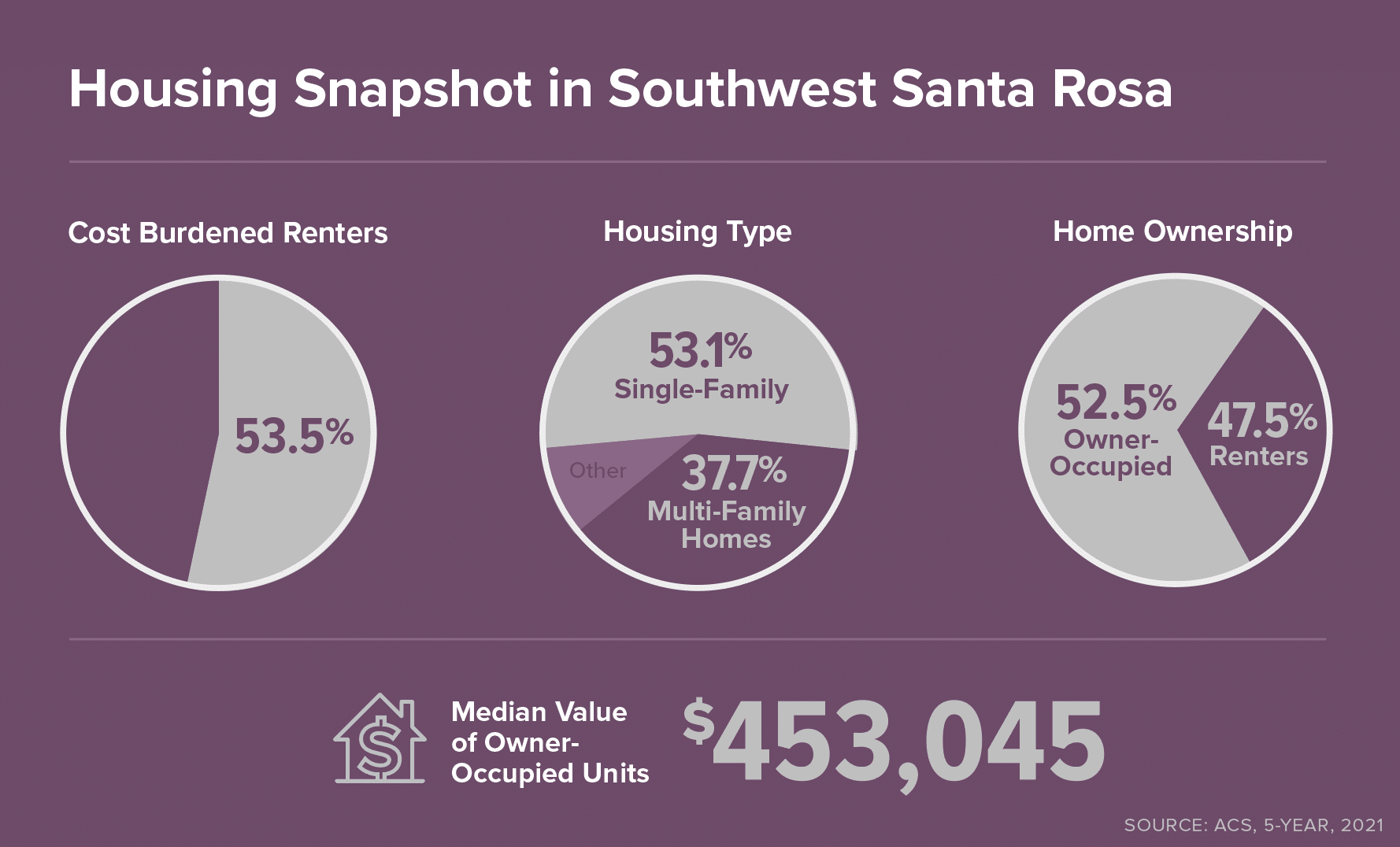
The age and quality of housing stock influence indoor air quality, temperature, and energy efficiency. Homeowners might invest in better insulation or double-paned windows while landlords of rental properties may have little incentive to do so.

Map Citations:

UC Berkeley Urban Heat Island Effect Map. 2010. “2010 Surface Temperature: Regional Quintile

Public Health Impacts of Heat Events

Southwest Santa Rosa experiences an average of 16 additional emergency room visits for heat-related problems on extreme heat days. Heat events have disproportionate impacts on children, the elderly, outdoor workers, and those with chronic illnesses and health conditions. 

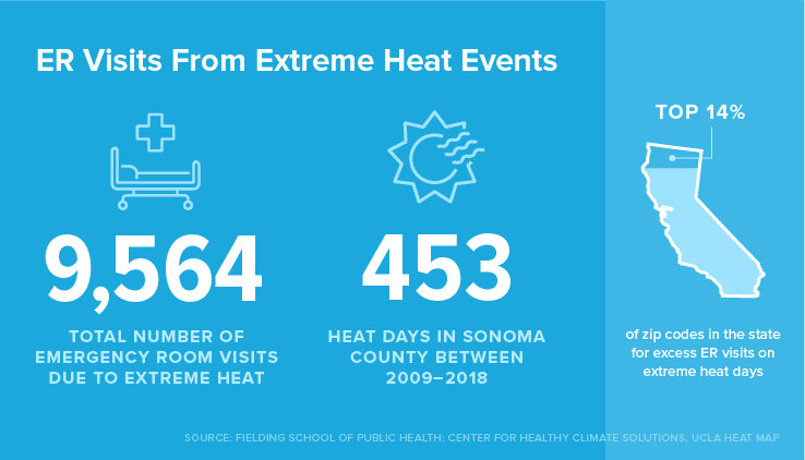
Over the period from 2009 to 2018, there were 9,564 ER visits due to extreme heat in Southwest Santa Rosa alone—this averages to nearly 1,000 ER visits per year for heat-related illnesses (UCLA). Heat events are one of the most deadly climate disasters, causing more than 7,800 deaths nationally over a 10-year period (Climate Toolkit).

Populations with higher rates of asthma and pollution are more susceptible to heat-related illnesses. Additionally, factors like language, documentation status, and whether or not an individual has health insurance may inform a person’s decision to seek medical attention when they are experiencing heat stress.

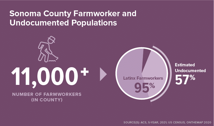
Less than one-third of farmworkers have some form of health insurance (Sonoma County Department of Health Services, Sonoma County Farmworker Health Survey (FHS) 2013 –14). Nationally, farmworkers are 20 times more likely to die from illnesses related to heat stress than U.S. civilian workers overall.

Wildfire

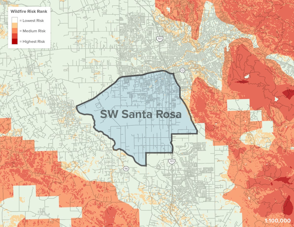
While Southwest Santa Rosa does not experience high wildfire danger, the 2017 Tubbs Fire that broke records for being the most destructive fire in California history is still fresh in the memory of many people who were directly and indirectly impacted.

Fire Risk

Multiple fires (Kincade, 2019; LNU, 2020; Glass, 2020) in the past decade have left their mark on Santa Rosa. 

Wildfires have myriad direct and indirect effects on residents, from destroying homes and businesses to driving up rental prices and exposing kids and outdoor workers to harmful smoke impacts. 

Because wildfire season coincides with the vineyard harvest, farmworkers are disproportionately exposed to wildfire smoke.

Map Citations:

Greenbelt Alliance. 2022. “Hotspots Fire Map.”

Sprawl &
Urban Greening

Southwest Santa Rosa’s development history has resulted in a checkerboard of development interspersed with agricultural uses and open spaces, especially around the former Airport. This offers opportunities to expand access to parks and open spaces to make heat refuge, recreation, and health benefits available to local residents, and children in particular. This is of vital importance considering the community’s current lack of parks and green spaces as compared to the rest of the city.

Tree Canopy & Urban Greening

Southwest Santa Rosa is a priority location for tree planting and park development vital for mitigating extreme heat impacts and environmental pollutants and improving public health outcomes (especially for youth populations).

Tree Canopy

The city of Santa Rosa maintains a park standard of six acres of parkland per 1,000 residents (2020 General Plan). However, Southwest Santa Rosa has less than 1 acre of parks per 1,000 residents—amounting to 7% of Santa Rosa’s total 531 acres of parkland.

Of the 27 neighborhood and community park sites that are proposed in the General Plan to serve the city’s growing population, 16 are located in Southwest Santa Rosa.

The Trust for Public Land’s ParkServe tool identifies neighborhoods most in need of new parks based on the percentage of residents who live within a 10-minute walk of a local park. Neighborhoods on both sides of Highway 101 are designated as high-park priority areas.

The need is probably even higher when considering the lack of adequate sidewalk and bike infrastructure in Southwest Santa Rosa, which further limits the ability, for children in particular, to access local parks and open spaces. Bay Area Greenprint also identifies high-priority tree planting areas along Highway 101 and Highway 12.

Map Citations:

California Healthy Places Index: Public Health Alliance of Southern California. “Tree Canopy.” 2022. Accessed June 1, 2023. https://api.healthyplacesindex.org/.

Conservation & Sprawl

Southwest Santa Rosa includes land at risk of sprawl development interspersed with lands essential for regional conservation goals. These lands present a unique opportunity to expand access to green space and park amenities for local residents while protecting vital habitats.

Essential and Important Lands for Conservation Goals and Sprawl Risk
1. Conservation Land Network
2. Sprawl Risk

Until recently, much of Southwest Santa Rosa was unincorporated and lay outside of the city’s Urban Growth Boundary, which led to sprawling development patterns.

Many undeveloped parcels are used for farming and agricultural operations, which are vital to the region’s conservation goals.

The conservation of natural and working lands provides community and environmental benefits including carbon capture and greater access to healthy foods.

Map Citations:

Conservation Land Network: Together Bay Area.”Full CLN 2.0 GIS Database (Version 2.0.1)” Accessed July 12, 2023. https://www.bayarealands.org/maps-data/#maps.

Greenbelt Alliance. “At-Risk 2017 GIS Data.” Accessed February 20, 2023. https://www.greenbelt.org/at-risk-2017-gis-data/.

Social & Health

Residents of Southwest Santa Rosa are more likely to experience adverse impacts as a result of climate change hazards due to housing insecurity. The rising costs of living in Sonoma County can make it increasingly difficult for low-income, Black, and Latino homeowners and renters to respond to and recover from climate shocks.  

Housing

Over 50% of Southwest Santa Rosa’s renters are “cost-burdened,” and unequal access to homeownership has led to mounting displacement pressure and climate vulnerability.

Southwest Santa Rosa is the most populous low-income area susceptible to displacement in Sonoma County, and it is surrounded by many areas that are at risk of becoming economically exclusive (Urban Displacement Project).

Climate change is amplifying displacement. In the months following the 2017 Tubbs Fire, which destroyed 5% of the homes in Santa Rosa, rental costs increased three times faster than usual as displaced families sought new places to live.

In Sonoma County at large, home prices have increased by over 40% between 2016 – 2021 (NPR). Black and Latino renters are disproportionately impacted by moderate and severe rent burden in the county. The average home value also varies by race, with white people owning higher-value homes in general. These inequalities make it difficult for low-income and Black and Latinx renters to find housing after climate shocks like wildfires.

Farmworkers & Undocumented Workers

Many of the farmworkers in Sonoma County’s agricultural industries reside in Southwest Santa Rosa. Farmworkers are an integral part of the city and regional economy, yet they often face the greatest impact of environmental hazards and are left out of disaster recovery efforts.


Over 11,000 farmworkers are employed in Sonoma County, and 95% of those are Latinx. In California as a whole, 90% of agricultural workers are immigrants from Latin America, and an estimated 57% are undocumented (Ramirez, Mines, and Carlisle-Cummins, 23 Gardner, Fire Recovery in Sonoma County). Many farmworkers in Sonoma County and Southwest Santa Rosa experience barriers to climate disaster recovery efforts due to language access and documentation status.

Hazardous outdoor working conditions due to extreme heat and wildfire smoke add to other environmental health risks associated with agricultural work, like pesticide exposure.

As climate change makes harvests both riskier for farmworkers and less productive, knowledge is being shared about land stewardship, restoration, vegetation management, firefighting, and wildfire resilience (North Bay Jobs for Justice).

Pollution Burden & Public Health

Southwest Santa Rosa’s location between highways and the regional airport results in poor air quality, which can severely impact children and people working outdoors.

CalenviroScreen Map and Indicator Maps (SW Santa Rosa)
1. Cumulative Environmental Risk
2. Diesel Particulate Exposure
3. Groundwater Threats

Bordered by Highways 12 and 101 and adjacent to the regional airport, census tract 1531.04 in Southwest Santa Rosa ranks in the top 96th percentile for exposure to diesel particulate matter, the 89th percentile for populations with cardiovascular disease, and the 80th percentile for those with asthma (CalEnviroScreen). Other tracts in Southwest Santa Rosa also experience high pollution burdens with high asthma rates across the neighborhood.

Map Citations:

California Office of Environmental Health Hazard Assessment (OEHHA). 2021. “CalEnviroScreen 4.0 GDB file.” Accessed June 16, 2023. https://oehha.ca.gov/calenviroscreen/report/calenviroscreen-40.

Community Partners

Other Key Community Leaders

Opportunities for Resilience

The following goals and recommended next steps have been informed by conversations and feedback from a variety of local stakeholders as well as a thorough review of past and ongoing documents and studies, with support from data analyses and land-use and planning expertise. 

GOAL

Reduce heat impacts and improve health outcomes by expanding Southwest Santa Rosa’s tree canopy and access to green space.

NEXT STEPS

Support funding and development for an urban greening plan to reduce heat impacts that in turn will address the existing inequities in tree canopy, expand active transportation infrastructure, and increase park access in Southwest Santa Rosa.

Mitigate potential negative impacts of greening efforts by working closely with local partners and community members to identify, prioritize, and implement projects that are locally responsive and culturally appropriate. 

Increase public awareness around the risks of extreme heat and mitigation strategies.

GOAL

Establish cooling centers and resilience hubs that can provide refuge during heat events and other emergencies.

NEXT STEPS

Support existing efforts to establish a resilience hub to serve the Southwest Santa Rosa community.

Evaluate public schools as potential climate refuge centers and consider potential for schoolyard greening.

Work with local partners to expand access to refuge centers through appropriate programming, outreach, and management.

GOAL

Prepare all Southwest Santa Rosa residents for extreme heat events and climate emergencies.

STRATEGIES

Support and empower local leaders and existing service networks to educate and inform the community about heat risks, local resources, and emergency response.

Conduct research to better understand factors that contribute to heat vulnerability in the community. This may include work sessions with promotoras, further research into local demographics and housing conditions, identifying strategies to build social and economic resilience, and partnering with youth leaders.

Encourage health officials and City staff to partner with and resource trusted community members to comprehensively address climate risks and build resilience across cultural and language barriers, while incorporating local residents’ experiences and needs.

Barriers to Action

  1. Extreme heat is not given enough public attention despite being one of the most deadly climate hazards.
  2. The Southwest Santa Rosa community has a number of residents who may not feel comfortable accessing public resources due to negative past experiences, distrust of public agencies, and language and cultural barriers.
  3. The Southwest Santa Rosa community has inadequate access to parks and active transportation infrastructure.

Southwest Santa Rosa Actions & Updates

Learn About the Importance of School Greening

Attend an online lecture by Green Schoolyards America to learn more about how to start greening schools in your community and how schools can play an important role in climate resilience.

LEARN MORE AND SIGN UP
Get involved in the Santa Rosa General Plan

The City of Santa Rosa released the Draft General Plan update as part of Santa Rosa Forward. The City is currently inviting comments on the draft as it goes through environmental review. 

GET YOUR VOICE HEARD
Join LandPaths for a Drop-In Gardening Day at Bayer Farm and Garden

Wednesdays and Fridays from 10am to 4pm & every third Saturday from 9am to 12pm.

GET INVOLVED
New Resource on Housing and Climate Justice

Check out Right to the City’s new framework for Housing and Climate Justice Policy, with contributions from North Bay Organizing Project.

READ NOW
Southwest Santa Rosa Hotspot in the Media

North Bay Resilience Manager CC Ciraolo was featured in KneeDeep Time’s article on why Southwest Santa Rosa is a resilience hotspot and what the initiative is all about.

READ NOW
Scroll to Top