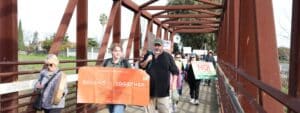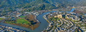

The Carquinez Strait Regional Shoreline encompasses more than 1,400 acres of bluffs and vistas in the rolling hills above Crockett. Managed by the East Bay Regional Park District, the area is a gateway to the delta along Contra Costa County’s northern edge.
The park is actually divided into two sections, separated by private property. This outing from the Bull Valley staging area in the western section offers an easy overlook loop walk with stunning views of Carquinez Strait to the north and Suisun Bay to the east.
About 1.5 miles long, the walk is very level and a perfect outing for those not in marathon-runner shape. If you want to hike further, you can continue downhill on a trail to Eckley Pier, which juts into Carquinez Strait. Add about another mile if you go to the pier and back. This trail is fairly steep.
Before you go, print out a trail map at bit.ly/RNzjeZ. Make sure to bring a hat and water. Dogs must be on leash in the parking lot and under voice control elsewhere.
The overlook loop
Take in the view of Carquinez Strait from the Bull Valley staging area parking lot. Pass an information sign and pit toilet and start out on the broad fire road. The sound of a passing Amtrak train will remind you how close you are to civilization.
To your right are the rolling hills above Crockett, to your left, Carquinez Strait and the Carquinez Bridge. Stay on the broad trail closest to the water, ignoring the smaller trails that cut over the hills to your right. You will pass a bench, lots of coyote brush and, unfortunately, some poison oak. Look for hawks and turkey vultures soaring overhead.
At about half a mile, you come to the beginning of the actual loop with a sign showing the Carquinez Overlook Loop Trail going both left and right. For now, continue left and cool off as you pass through a thick eucalyptus grove. When you emerge, you will find a bench at a perfect lookout spot. As you gaze over the strait, look for Martinez and Mount Diablo.
Continue around the loop. If you want a variation, just before you return to the sign, take a trail uphill to the left. This lets you roam around the hillsides a little bit as you wind your way back to the Bull Valley staging area.
Eckley Pier
After returning to the Bull Valley staging area, you can continue downhill on the Bull Valley Trail to Eckley Pier, where you will find full facilities – water, restrooms, picnic tables and information.
If you prefer, you can drive the short distance to Eckley Pier. (The road is not shown on the map.) This is a good place for a picnic lunch. Walk out on the pier for a spectacular view of the Carquinez Bridge.
On the pier, people fish for striped bass and sturgeon, aided by wind shelters and fish-cleaning stations. No license is required for fishing from the pier.
On your return to the Bull Valley staging area, which is an uphill walk, stop at the overlook bench, where a cool breeze from the strait will refresh you. If you neglected to pack a lunch, on your return along Pomona Street, stop in Crockett (home of C&H Sugar) at the Valona Deli (1323 Pomona St.), where you can get sandwiches, salads, soups and coffee.
Getting there
By car from San Francisco, cross the Bay Bridge and continue north on Interstate 80 to Pomona Street (Exit 27). This is the last exit before the Carquinez Bridge.
Go east on Pomona, passing through the town of Crockett. Pomona becomes Carquinez Scenic Drive. Continue for about 2.5 miles until you reach the Bull Valley staging area on your left.
Read more: http://www.sfgate.com/outdoors/urbanoutings/article/Carquinez-Regional-Shoreline-walk-3979092.php#ixzz2ECn0JA5D