
When considering the significant impact that development has to natural and agricultural lands, we must consider the values they provide to the Bay Area. Five critical values for these lands we found were:
- Fresh food: the Bay Area has 2.3 million acres of agricultural land (powering a $6.1 billion agricultural economy, according to HomeGrown).
- Water: the region’s 1.8 million acres of land provides water resources—watersheds and wetlands–catching, cleaning, and storing water.
- Wildlife: there are 2.5 million acres of land that is important for wildlife—habitat, corridors, and biodiversity.
- Recreation / Access to Nature: 1,600 miles (that’s a lot!) of trails, including planned trails, that will someday connect all 9 counties, such as the Bay Trail and the Ridge Trail.
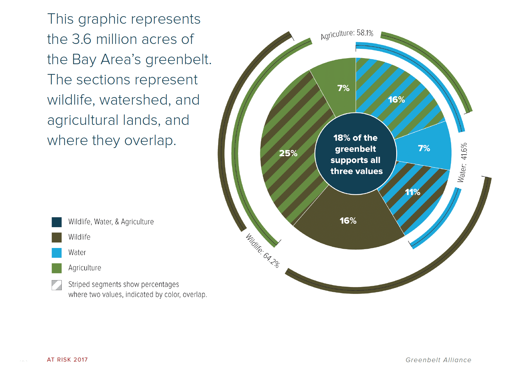
These values overlap, as one piece of land can provide several benefits—from recreational use and agricultural benefits to water sources and wildlife habitat. In the graphic below, we have analyzed how much of the Bay Area greenbelt supports the major values of Water, Agriculture, and Wildlife, both individually and in overlapping areas that support multiple values.
Regionally, the values at risk can directly impact residents
Clean drinking water is at risk:
- Natural and agricultural lands catch and filter rain, replenishing groundwater supplies. This service is threatened by development because if lands are paved over, they cannot collect water. This is especially important in areas that rely on groundwater as for a drinking water source.
- If the region’s at-risk landscapes are lost to sprawl development, 46 billion gallons of water—a year’s worth of water for 677,000 households—is at stake.
The climate is at risk:
- Bay Area ecosystems, especially forests and wetlands, are very efficient at storing the greenhouse gas, carbon. Together, the region’s at-risk landscapes store more than 6 million metric tons of carbon. If these lands are developed, the carbon that would be released is equivalent to putting 1.3 million cars on the road every year.
Within Specific Counties, Major Values will be Lost if Development Occurs
- Santa Clara: Farmland in Santa Clara County desperately needs conservation. With an astounding 56% of the county’s farmland at risk of development, this resource is very close to being lost forever.
- Contra Costa: Contra Costa County has 41% of the Bay Area’s at-risk critical habitat lands. The future of many of the region’s remaining burrowing owls, kit foxes, and other rare species depends on the county’s growth decisions.
- Sonoma County: More than half of Sonoma County’s water—both for drinking and irrigation—comes from groundwater. The lands that collect this water are at risk—in fact, 28% of all the region’s at-risk groundwater basins are in Sonoma County. Protecting this land is essential, for water and for the people who depend on it.
- San Mateo County: Though it’s the region’s smallest county, it has the second most above-ground stored carbon at risk: 257,700 metric tons. Protecting land in San Mateo County benefits the climate—and everyone who depends on it.
Get the At Risk report here.
Photo by Marc Crumpler ©