
A wooden viewing platform lets you watch the hang gliders as they soar above the dunes and sandstone cliffs in graceful aerial ballets. Bring a windbreaker and enjoy the views: On clear days, the viewing platform offers vistas all the way to Point Reyes to the north as well as the Farallon Islands to the west.
The fort is also one of the Bay Area’s most popular dog-walking destinations. You’ll see dogs of every type cavorting along the dunes and in the waves.
On the south end is a ranger station and also oldest plant nursery at the Golden Gate National Recreation Area. Volunteers collect seeds from wild plants, remove invasive ones, and grow and plant native plants throughout the park.
Like Fort Point and Fort Mason, Fort Funston is a former military site, used for coastal defense, that today is devoted to recreation and education. The Fort Funston parking lot was once a Nike missile launch area.
The trails: Many well-used informal trails zigzag over the dunes. You can also walk the paved, wheelchair-accessible Sunset Trail, which crosses coastal scrub and dunes to offer spectacular views of Lake Merced, the San Francisco hills and the Pacific Ocean. From the parking lot, head north on the trail (water on your left), threading your way through the dogs and strollers. Take a minute to check out Battery Davis, built in 1938, with a bombproof chamber to protect the cannons within. Today, a more peaceful Battery Davis is surrounded by picnic tables and benches. Continue on the Sunset Trail past the Beach Access sign until the paved portion of the trail ends.
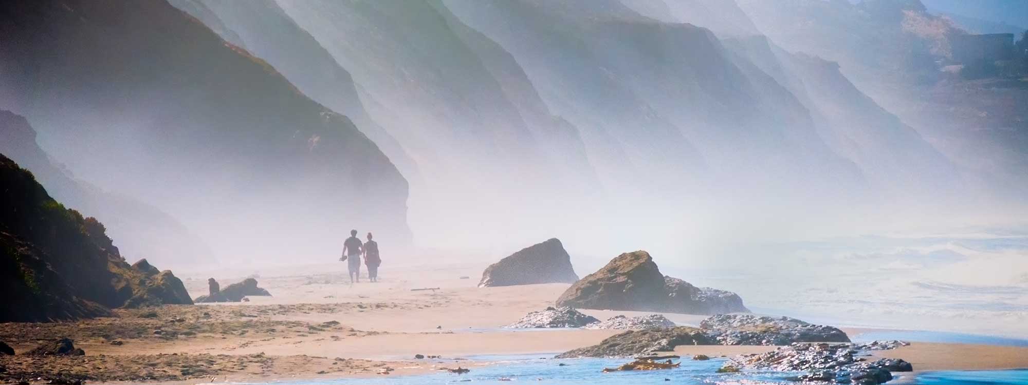
The beach: During low tide, you can stroll along the beach, enjoying the rugged sandstone cliffs, which in some places are more than 200 feet tall. To reach the beach, you have two options. You can take the steep Sand Ladder Trail just south of the hang-gliding platform. You’ll be walking across the hang-glider landing area, so be on alert! The trail is essentially a huge hill of sand with horizontal logs forming the “steps,” a somewhat difficult route with a short rock scramble at the end. An easier way to reach the beach is to walk along the Sunset Trail past Battery Davis to the beach access sign and follow the sandy path to the water. If the tide is low enough, you can walk along the beach from one access point to another. However, during higher tides, you will find it impossible to cross the huge sewage pipes lying, most unromantically, across your path at the sewer overflow structure along the beach. As you walk, enjoy the striking rock formations and the many colors streaking the sandstone cliffs.
Getting there: By car, from San Francisco, follow the Great Highway south to Skyline Boulevard (Highway 35). Turn right. Go 0.3 miles past the traffic light at John Muir Drive to the entrance to Fort Funston on the right.
From the Peninsula, head north on Highway 280, taking exit 47 to merge onto Highway 1 South toward Pacifica. Exit at Highway 35/Skyline Boulevard North. Make a U-turn at John Muir Drive. Then, after 0.3 mile, turn into the entrance to Fort Funston.
By bus, take Muni No. 18 and exit at John Muir Drive and Skyline Boulevard. Cross Skyline at the traffic light and then follow the trail up to Fort Funston.
By bicycle, from Golden Gate Park, take the pleasant multiuse path that parallels the Great Highway. At Sloat, cross to the ocean side of the Great Highway and continue on the Great Highway to Skyline Boulevard. Turn right on Skyline to the entrance to Fort Funston.
Photo: Ed Brownson via Flickr