
Most visitors to the Oakland Zoo in Knowland Park do not realize that the zoo occupies only 45 acres of the vast 525-acre Joseph Knowland State Arboretum and Park. The remaining parkland consists of large swaths of open space filled with hiking paths, birds, wildlife and stupendous views. Upper Knowland Park offers no restrooms or picnic tables, but plenty of trails.
The entire parcel was acquired by Oakland from the state in 1975. A proposed 60-acre expansion of the zoo is being challenged by neighbors and others who want to preserve the upper park as open space.
The area’s pristine condition is partly due to the efforts of Oakland resident John LaFleche, who has lugged tons of trash from the park — tires, discarded bicycles, car parts, wine bottles, chairs, golf balls and even a dishwasher.
What you’ll find
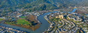
Upper Knowland Park spans both sides of the eastern end of Golf Links Road and extends to Skyline Boulevard. Here, just a few feet from homes, you step into wild terrain shared by coyotes, foxes, skunks, gophers, turkeys, raccoons, rabbits and snakes. Native oaks populate the hills and raptors soar overhead.
Begin your outing at Cameron Avenue, which dead-ends at the park. Although there are no trail signs, you won’t get (too) lost because the park is bounded on the south side by homes and the bay is visible to the west.
A favorite walk
A Knowland Park enthusiast suggests this walk: Enter the park through the fence opening at the end of Cameron Avenue. Just inside, look for a little stone bench. (This is the only bench and a good place for a picnic lunch.) Cross a fire road and stroll straight ahead on the little footpath worn in the grass, which heads slightly northwest. From this path, enjoy wonderful views of Oakland, San Francisco and the bay, as well as the lush green oak-studded hills to the west. Join a wide fire road and veer right. When you come to a grouping of four fire roads, turn hard left and go downhill toward the bay.
At the bottom of the hill, make your way around a dirt area and turn left on the path up “Heartbreak Hill.” While climbing, look back for views of the mesa from which you came and the rock outcroppings. On a clear day, the summit affords views of five bridges (Dumbarton, San Mateo, Golden Gate, Bay and Richmond-San Rafael) as well as downtown Oakland and San Francisco.
Stroll along the ridgetop, and then turn right (north) on the more gentle path heading back downhill to another intersection of fire roads. Most of the roads going from this area lead to dead ends or to the back fence of the Oakland Zoo. The main one, to your left, goes past a small cell phone antennae station, heads downhill a short distance and makes a nice small loop through a beautiful grove of oaks. Go as far as you like and then double back.
Back at the intersection, turn left and walk east toward the mesa area where you were earlier, heading downhill to the dirt area at the bottom. From here, you can return to your starting place and have a picnic lunch on the lone bench or keep exploring on one of the other fire roads.
Getting there
By car from San Francisco, cross the Bay Bridge and take Interstate 580 east toward Hayward, exiting at 98th Avenue/Golf Links Road. At the bottom of the off-ramp, turn left at the light and go under the freeway. Go through the light and past the zoo entrance on the right, continuing up the hill on Golf Links Road for about 1.7 miles. Take a right on Caloden Street, which winds around and becomes Malcolm Avenue. Then turn right on Cameron Avenue.
Photo: Skimack via Flickr