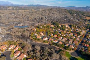
Greenbelt Mapper

The Greenbelt Mapper, an interactive online map, showcases where land is zoned for development, where growth managementA local program limiting the rate of community growth. Communities use a wide range of techniques to determine the amount, type, and rate of development desired by the community and to channel that growth into designated areas. Growth management policies can be implemented through growth rates, zoningThe division of a city or county by legislative regulations into areas, or zones, which specify allowable uses for real property and size restrictions for buildings within these areas; a program that implements policies of the general plan., capital improvement programs, public facilities ordinances, urban limit lines, standards for levels of service, and other programs. Examples include an annual cap on the number of building permits issued, tying new development intensityThe degree to which land is used. 0ften used interchangeably with densityThe amount of development per acre permitted on a parcelA lot, or contiguous group of lots, in single ownership or under single control, usually considered a unit for purposes of development. under the applicable zoning., intensity has a broader — though less clear — meaning, referring to levels of concentration or activity in uses such as residentialLand designated in the city or county general plan and zoning ordinance for buildings consisting only of dwelling units. May be improved, vacant, or unimproved., commercialA land use classification that permits facilities for the buying and selling of commodities and services., industrialThe manufacture, production, and processing of consumer goods. Industrial is often divided into "heavy industrial" uses (such as construction yards, quarrying, and factories) and "light industrial" uses (such as research and development and less intensive warehousing and manufacturing)., agricultural, recreation or parking. to infrastructureA general term for public (and quasi-public) services and facilities, such as sewage-disposal systems, water-supply systems, other utility systems, and roads. capacity, or limiting the location of new development. (See Congestion management plan.) measures are in place, and the many values open spaceAny parcelA lot, or contiguous group of lots, in single ownership or under single control, usually considered a unit for purposes of development. or area of land or water that is essentially unimproved and devoted to an open space use for the purposes of (1) the preservation of natural resources, (2) the managed production of resources, (3) outdoor recreation, or (4) public health and safety. provides.
GIVE IT A TRY >>