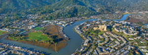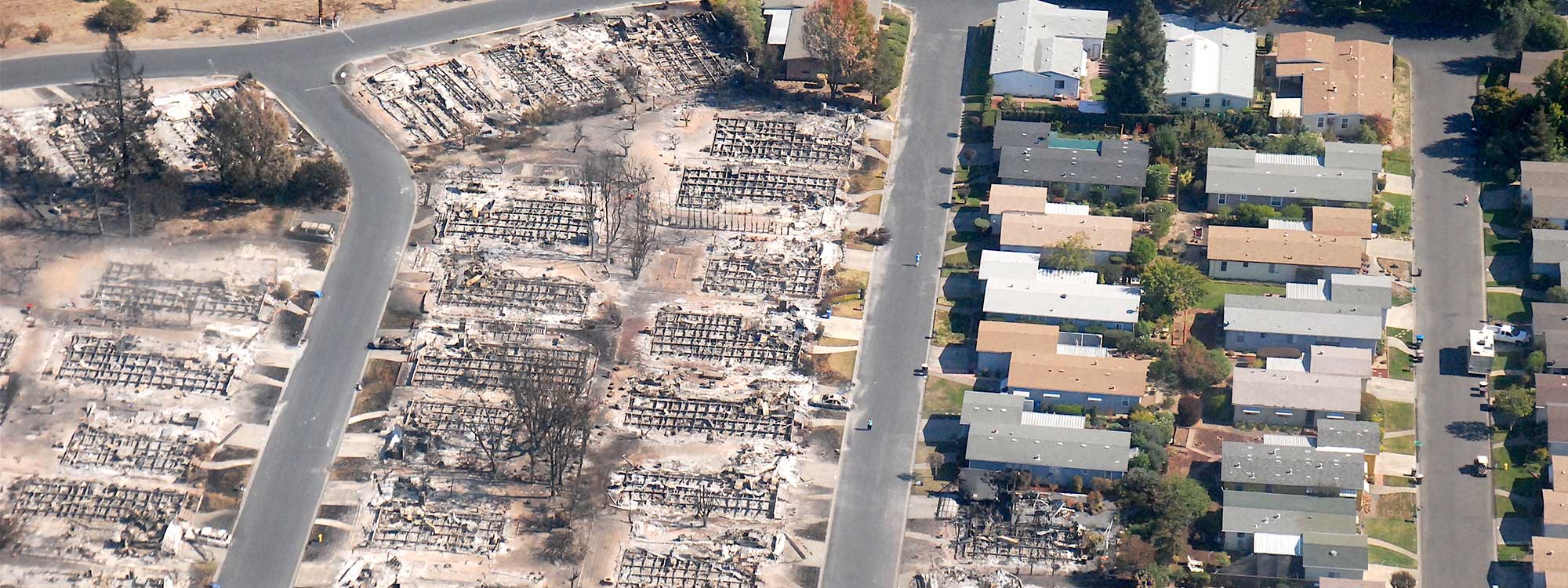

In the wake of incredible losses and the record-breaking wildfire season California had in 2020, along with increasingly severe drought conditions, our state, regional, and local governments must urgently do more to keep communities safe from wildfires while also addressing the acute housing crisis Californians are facing.
Planning where and how new development is built, and what requirements are in place to reduce risk of existing development currently in the Wildland-Urban Interface, will influence how vulnerable current and future communities are to wildfire.
Greenbelt Alliance joined SPUR and California YIMBY in developing and supporting the following principles to guide planning for managing wildfire risk and new development. Collectively and individually, our organizations will be pushing for state as well as local and regional policy leadership in decisions that uphold these principles.
The connection between housing policy and climate change is clear. If urban areas fail to produce dense housing in walkable neighborhoods near transit and jobs, more and more people will drive, contributing to greenhouse gas emissions and fueling hotter temperatures. In California, our land-use patterns have resulted in sprawl development that increases our GHG emissions and contributes to devastating climate impacts like historic heatwaves and drought that dry out vegetation—exacerbating the wildfires that burn down homes and pollute our air.
The State has a responsibility to keep communities safe from wildfires and other hazards. It also has a responsibility to ensure that enough housing is produced to meet the needs of all Californians. How should state leaders balance these two goals?
These principles are meant to guide the management of wildfire risk and growth. It is critical to the future of the state to tackle these goals together and in doing so, we can help create a stronger California for everyone.
Planning Principles for Managing Wildfire Risk and New Development
1. Support higher density growth in in-fill locations that aren’t impacted by wildfire risk.
One of the single most important things we can do to mitigate wildfire risk and support the creation of new homes is to build as much housing as possible in areas that are less impacted by wildfire risk that are not located in the Wildland-Urban Interface (WUI). Supporting growth in safe infill locations includes zoning for more housing in low-risk areas, making the permitting process faster, and aligning public resources to support the construction of affordable housing in these places.
2. Differentiate between different levels of wildfire risk and develop regional planning tools for determining fire risk to inform growth plans.
Planning for wildfire risk requires differentiating between different types of risk. There are some parts of California that are highly likely to burn again and again.
There are also different types of fires that occur in different parts of the state based on variations in vegetation, topography, climate, housing density, and road networks. For example, coastal Southern California is more likely to experience fast-moving fires spread by high winds that consume grasslands, whereas forested areas in Northern California and the Sierras are likely to see fuel-driven fires. These different conditions require different planning tools to manage and mitigate.
Because fire risk is based on climate, vegetation, and topography, Councils of Governments (COGs) and Metropolitan Planning Organizations (MPOs) should be tasked with taking fire risk into account as part of the development of Sustainable Community Strategies (SCS). As part of an SCS, regional planning agencies can recommend which parts of the region are safest from a fire hazard perspective, which parts are protectable with mitigation, and which parts should remain undeveloped.
To help inform regional plans, state fire maps need to be updated and refined. CAL FIRE maps that designate state responsibility areas, very high, high, and moderate fire hazard severity zones are several years old. These outdated maps don’t reflect areas that have already been developed that should be removed from the maps and may not account for the growing risk of a longer, drier fire season associated with climate change. These types of mapping tools should be refined statewide by CAL FIRE and updated on an ongoing basis so that they can be used to support appropriate mitigation.
3. Don’t build new housing or job centers in areas of the highest wildfire risk as defined by regional planning processes such as the Sustainable Communities Strategy.
Concentrating growth in places with low or even moderate hazard risk is necessary to address California’s housing crisis. In these instances it is beneficial to distinguish between areas that are already developed, where urbanization could be further encouraged, and areas that are undeveloped, where conservation efforts may need to be pursued.
However there are some places where fire risk is so significant, or where multiple hazards (earthquake, landslide, etc.) overlap, that we simply should not be building new housing or job centers there. This multi-hazard approach is important to utilize when thinking about where to encourage and where discourage growth. When high risk areas are entirely undeveloped, they should be protected by conservation efforts including the purchase of the land or conservation easements in these areas to ensure that they are never built on.
As mentioned above, mapping and planning tools need to be further refined and utilized at the regional scale so that these no-growth areas are defined with precision. Additionally, to ensure that wildfire risk is not used as an excuse to prevent new housing construction from occurring in appropriate locations for growth.
4. Develop guidance to inform how existing towns and cities with higher fire risk should approach growth and mitigation.
There are many places throughout the state—cities and towns in more rural areas, but also more urban areas that are adjacent to wilderness—where fire risk is high, but where growth has already occurred and additional growth may be planned for and needed to address the housing shortage. In these places, it is important to use community planning tools to help manage and mitigate risk. For example, should growth be discouraged on the periphery of town and encouraged in the center? Should a fire break be built between the developed part of town and the wilderness area? In general, building more densely can help increase the defensibility of a place. The State should help lift up best practices and provide funding and technical assistance to support communities in planning effectively to address fire risk.
It is important to note that as a state we have developed significant new fire-tested risk reduction strategies to reduce the threat posed by wildfires. Included in those strategies are project design requirements in the Fire Safe Regulations, fire-resistant building codes, indoor fire sprinklers that alleviate the possibility that a new home will cause a wildfire, wildfire requirements of the safety element of local general plans, wildfire risk considerations in California Environmental Quality Act (CEQA), defensible space requirements (including locating streets, irrigated landscaping, fire breaks, and increased defensible space around the periphery of the project), undergrounding utilities (e.g., power lines), and solar roofs that provide power when the grid is not available and also reduce dependency on power lines. Implementing these existing measures for new development will help reduce fire risk.
5. Harden existing structures and impose and enforce defensible space requirements.
There are 14 million existing homes in California, most of which were not constructed with fire-resistant building codes of any kind and without defensible space requirements. As a result, we see that structures that are lost during wildfires almost always fall into this category. Even in cases where some form of requirement was in effect, they were not enforced. It won’t make a difference if a structure has defensible space at the time construction was completed, if thereafter, vegetation is planted or allowed to grow in a manner that violates defensible space requirements. Mitigation standards should be regionally defined to manage the type of fire that threatens the location. The State should develop financing tools to ensure that homes for low- and moderate-income households in these locations are retrofitted to be fire safe.
6. Align utility planning and insurance regulation policies with wildfire risk and growth plans.
As California’s population continues to grow, it is important to take utility planning into account. The State should be working with private operators and planning with public operators to ensure the safety of existing systems by preparing for on-going maintenance and upgrades, as well as thinking through the interdependence of these systems and how to keep them running during a major event. Insurance for private property should likewise be regulated to ensure that fire insurance is affordable and available for homes in areas where growth is encouraged and priced to reflect risk in areas where development should not be supported.
These Principles Guide Greenbelt Alliance’s Work In Local and Regional Advocacy
For example, we are putting these principles into action in our campaign for strong, environmentally-focused Housing Elements as cities and counties are updating their plans this year. We are publishing research and policy recommendations for how the Bay Area should prioritize protecting, expanding, and stewarding open spaces, parks, and preserves in and around communities in high wildfire risk areas for their wildfire risk reduction benefits to people and landscapes. In a Resilience Playbook, we are curating our recommended policies to enable infill development, wildfire risk reduction, and the wildfire resilience benefits of greenbelts in land-use planning. We continue to endorse climate-smart development that reduces greenhouse gas emissions and increases our resilience to climate-related risks like flood, fire, and drought.
Stay tuned for our forthcoming research papers, Resilience Playbook, and ways to join us in advocating for climate-resilient land use that reduces wildfire risk and advances housing options across the Bay Area.
Photo: California National Guard via Flickr