
The place where Harold drove his Jaguar off a cliff in the cult movie “Harold and Maude” is today the 105-acre site of freshly restored hiking trails and inviting habitat for endangered species.
Threatened with development for more than 30 years, Mori Point in Pacifica was transferred to the Golden Gate National Recreation Area in 2000. Since then, the GGNRA has restored wetlands, dug a pond, built a raised boardwalk over fragile habitat and created a trail with steps to the top of Mori Point bluff, which on clear days offers stunning ocean views north to Point Reyes, south to Pedro Point and west to the Farallon Islands in the Pacific.
Although the Mori family were originally farmers, by the 1920s their primary business was the Mori Point Inn, a popular drinking place – especially during Prohibition. Federal agents raided the tavern in 1923, seizing 24,000 cases of whiskey. The inn was reborn as a hotel, restaurant and dance hall, but was condemned in 1965 and burned down soon afterward.
The hike to the point and back is just over a mile. However, it’s another mile each way if you walk along Sharp Park beach to the municipal pier. You can extend the hike as far as you want by taking one of the trails south and east at the top of Bootlegger Steps.
Bring water. A pit toilet is available at the Old Mori Road trailhead.
What you’ll find
The trailhead puts you on Old Mori Road, a broad, flat, tree-lined path leading toward Sharp Park beach with its dramatic black sands. You come to a mileage sign, a pond and information signs telling you about the history and ecology of the region, particularly about the threatened red-legged frog and the endangered San Francisco garter snake.
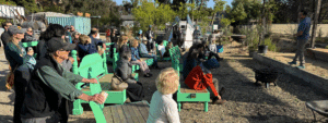
Stay on Old Mori Road to enter a long, raised boardwalk lined with benches. The boardwalk allows environmentally friendly access to the ocean and to the point. You come to a kiosk with the ocean in front of you, Sharp Park Golf Course on your right and the hillside trails to your left.
Start walking up Bootlegger’s Steps (named after Mori Point’s reputation during Prohibition). At the top is a large flat area, where you can rest and take in views of the ocean, the beach, Pacifica and the hills beyond. A sign directs you to the actual point. Follow the trail, stopping at the warning sign. From the point, take in more views of the ocean with its dramatic coastline.
When you return to the flat area, you can follow the trail signs and extend your walk on one of three trails. The Unmaintained trail leads along the cliffs to Rockaway Beach. This is a rough trail with a creek crossing at the bottom. The Peak trail leads straight uphill to the peak to your south. The Coastal trail wanders along the hillsides before descending to a paved bike path, which you can follow a short distance to Rockaway Beach.
On your return, if don’t want to go down Bootlegger’s Steps, look to your right at the head of the steps and you will see a more gradual trail leading back down to the beach.
After the walk
If you’d like to extend your outing, continue north along the seawall path to the municipal pier. This mile-long levee runs between the beach and the Sharp Park Golf Course and keeps the sea from washing over the course during rough weather.
Known as “the poor man’s Pebble Beach,” the course was landscaped by Golden Gate Park Superintendent John McLaren and designed by famed golf architect Alister MacKenzie.
Dip down from the path if you want to walk in the dark beach sands, colored brown from high iron content. (Swimming is not recommended because of riptides.) Look for murres, terns, loons and cormorants fishing in the water.
When you come to the pier, stop at the informal Chit-Chat Cafe for coffee and some clam chowder. There are also restrooms here. On weekends, the cafe barbecues burgers, hot dogs and chicken outside, where you can sit and watch the ocean.
The pier itself is 1,140 feet long and is considered a premier spot for catching salmon and striped bass. You will find fish-cleaning stations and benches. No license is required for fishing off the pier.
Getting there
By public transportation, take the SamTrans 110 from Daly City BART or the SamTrans 112 from Colma BART to Westport Drive and Highway 1. Walk a few steps to Bradford Way and then turn left. When Bradford ends, you will see a gate to your right. This is the trailhead. Note: If you need to cross Highway 1, walk north on Bradford Way. Just past Fairway Drive, you will find a path that crosses under the highway. (Watch out for golf carts.)
By car from San Francisco, from Interstate 280, head south and take the exit toward Highway 1 south toward Pacifica. Take the first right after the “End Freeway” sign onto Westport Drive and then immediately turn left onto Bradford Way. Street parking is available. Where Bradford ends, you will see a gate on your right. This is the trailhead.
This article has been corrected since it appeared in print
Urban Outings are presented by Greenbelt Alliance, the Bay Area’s advocate for protecting open spaces and creating vibrant places. To suggest an Urban Outing, contact Gail Todd, tour leader for S.F. City Guides and author of “Lunchtime Walks in Downtown San Francisco.” To find out more about Greenbelt Alliance’s work, visit www.greenbelt.org.