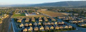
Greenbelt Alliance’s new report, “At Risk: The Bay Area Greenbelt,” finds that 293,100 acres of the Bay Area’s farms, ranches, and natural areas are at risk of sprawl development within the next 30 years. These lands provide fresh food, clean water, and spectacular scenery to Bay Area residents, as well as protection from floods and climate change. But today, a total of 458 square miles, almost 10 times the size of San Francisco, could be developed within the next generation.
Of those lands, 63,500 acres—99 square miles—are at high risk, meaning they face development within the next 10 years. On the At Risk Map, these bright red areas reflect dozens of proposals threatening to pave over ranchland, wildlife habitat, and wetlands. The map reveals a future Bay Area that could look very different.
“We’ve done a comprehensive review of what every city and county in the Bay Area is planning, and where land speculators are proposing new developments,” said Jeremy Madsen, Chief Executive Officer of Greenbelt Alliance. “These development threats are often invisible. By the time you see the bulldozers in the orchard, it’s too late.”
“But today,” Madsen added, “many of these proposed sprawl developments can still be stopped, if people speak up.”
Greenbelt Alliance creates the At Risk report every five years based on city and county plans, zoning, and development proposals across the region. The risk calculation also factors in future growth projections, including city and county maps of future development, as well as geography, such as whether land is flat, close to roads, and close to existing development. The organization also maps existing policies that protect land. This is the organization’s seventh At Risk report.
Senator Barbara Boxer wrote the report’s foreword, citing Greenbelt Alliance’s 59-year history.
“It’s impossible to imagine what the Bay Area would be like without those who started this movement to save our farmland and our hills,” wrote Senator Boxer. “This report continues that legacy by taking a closer look at every threat to this region’s magnificent landscapes and providing the kind of information decision-makers need to shape smart policy.”
Natural values at risk
In addition to mapping threatened lands, the At Risk report highlights the value of an intact greenbelt. Greenbelt lands benefit the Bay Area with spectacular scenery, drawing visitors and workers from around the world. These lands filter and hold drinking water, store carbon for climate protection, and provide habitat for diverse wildlife. The region’s farmland and ranchland also provide fresh food year-round, fueling a $6.1 billion agricultural economy.
The report includes examples what could be lost if lands are developed:
- Clean drinking water is at risk: Undeveloped Bay Area lands catch and filter rain stored as groundwater. But if lands are paved over, they cannot collect water. This is especially critical in counties like Sonoma, where people need groundwater to drink. Developing the region’s at-risk landscapes could affect 46 billion gallons of groundwater, equivalent to the water supply for 677,000 households for a year.
- The climate is at risk: Bay Area ecosystems—especially forests and wetlands—store climate-changing carbon. The region’s at-risk landscapes store a total of more than 6 million metric tons of carbon. Developing these lands would release as much carbon as adding 1.3 million cars to the road every year.
County by county: Regional hot spots
The report maps eight Bay Area counties (San Francisco is not included, as its land is generally either developed or permanently protected as parks), and highlights the biggest current development threats in each county, as well as natural values at risk.
- The county with the most land at risk is Contra Costa, with 62,000 acres threatened by sprawl, especially in the east around Brentwood, Antioch, Oakley, and Pittsburg. These cities are all attempting to sprawl outward, though they have room to grow within city boundaries. Brentwood is attempting to annex a large area to its southwest, even after two “no” votes by residents. The county has 41% of the region’s at-risk critical habitat for wildlife, including burrowing owls and kit foxes.
- Solano County also stands out, with almost one of every 10 acres in the county at risk—especially around the city of Vacaville, which seeks to build out on rural lands. Solano is also the only Bay Area county with no public park agency to protect land. Though Suisun Marsh was recently protected, the county still has 27% of the region’s at-risk wetlands.
- In Santa Clara County, an astounding 56% of the county’s farmland is at risk of development. The city of San Jose is considering industrial development on agricultural land in northern Coyote Valley, and farmland around Gilroy is threatened by sprawl proposals.
The report also features some particularly ill-conceived development proposals. For example, the East Bay city of Newark is proposing to build a golf course and luxury housing on a wetland along San Francisco Bay, despite the area’s importance for wildlife—and its location below sea level.
Less land at risk today, but the pressure is on
Today, less Bay Area land is at risk—about 30,000 acres less—than in 2012, when Greenbelt Alliance released its last At Risk report. That improvement is especially impressive, said Madsen, given how high housing prices are, increasing pressure to build anywhere and everywhere.
“The housing market is superheated right now, and that’s driving a lot of speculation and pressure to develop land,” said Madsen. “But thanks to the long-term vision of Bay Area residents and leaders, more policies are now protecting thousands of acres of farms, ranches, and natural areas.”
Building sprawl development across the region’s rolling green hills won’t help the housing affordability crisis, said Madsen. The report cites research on sprawling car-dependent development, which is no more affordable for residents once transportation and demands on time are factored into the costs.
Market demand is high for homes in central areas. For example, in the foreclosure crisis, far-flung developments saw the biggest drops in value and took longest to recover.
“The Bay Area’s cities and towns need to keep building new homes close to jobs and good transportation options,” said Madsen. “People don’t want to drive for hours to get to work or do daily errands. People want walkable neighborhoods, and more time for friends and family. And we all need to help by saying ‘yes’ to those new homes in our communities.”
Existing cities and towns have room to accommodate all the region’s growth, as shown by Plan Bay Area, the region’s blueprint for growth over the next generation, if policies encourage “infill” development. These housing policies are an important complement to land conservation measures.
Local heroes and a federal champion
The report profiles local residents in each county who are working to protect land today. From surfers on the San Mateo coast to mothers and grandmothers in Napa and the East Bay, the report shares the stories of people who are speaking up, sharing stories of their vision and their hard work.
“The greenbelt is no accident. It exists because, over and over, people have taken action to save lands they care about,” said Madsen. “We are so glad to share these stories of folks around the region, who have been working tirelessly, often for decades, to save special places.”
Senator Barbara Boxer applauds these efforts as well.
“While I will not be in the Senate, I will never stop fighting for these issues,” wrote Senator Boxer, “and I hope you will join me in working to protect our pristine lands for generations to come.”
###
About the At Risk report: At Risk: The Bay Area Greenbelt is the definitive research on the farms, ranches, and natural areas at risk of being lost forever to sprawl development. At Risk brings to light—out of the depths of planning documents—what the region’s future could hold if we do not stop sprawl. Since 1989, Greenbelt Alliance has released this report every five years. Download the full report at greenbelt.org/at-risk-2017/
About Greenbelt Alliance: Greenbelt Alliance addresses a single challenge: how the Bay Area handles growth. We shape the rules that govern growth to protect the region’s open spaces and to ensure everyone can live in a thriving neighborhood. For nearly 60 years, we have shaped the amazing places of the Bay Area. greenbelt.org