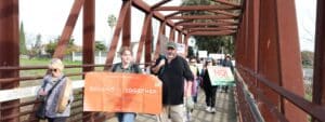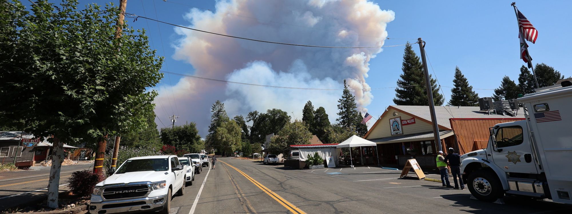
In the Bay Area, we’re no strangers to wildfires. Year after year we are forced to reckon with staggering statistics of the record number of homes destroyed and acres burned. But much less often do we hear about the rippling effects that wildfire events have on our frontline workers and unhoused neighbors, and even more seldom do we hear about the multi-year struggles to recover after losing a home or being unable to work. During the Camp Fire that struck Paradise, CA in 2018, the fire temporarily displaced 50,000 people at its peak and forced tens of thousands to relocate permanently. And during the Glass Fire in 2020, the Sonoma County’s Agriculture Pass (Ag Pass) program exposed more than 170 farmworkers to dangerous conditions while working within the fire perimeter harvesting grapes and other crops.
These unequal experiences with wildfire come from the disparities in socio-economic conditions, which are produced by systemic inequalities such as racial barriers to home ownership, redlining, historical disenfranchisement, and land-use practices that have maintained segregation and widened the racial wealth gap.
In order to have more equitable outcomes during and after wildfires, Greenbelt Alliance created the Wildfire Social Vulnerability Index (WSVI) to understand where social vulnerability to wildfire is greatest across the Bay Area.
The WSVI is a stand-alone map layer that draws from existing research and data to develop indicators in six areas: income, education, accessibility, race and ethnicity, health, and housing. We then evaluated 15 indicators relative to the Bay Area, which means that our wildfire-specific Social Vulnerability Index is one of a kind in its ability to rank census tracts relative to our region alone. While this may sound like a minor detail, this information is actually critical. With it, we can identify places that may not be showing up at the state or federal levels as disadvantaged communities but are nonetheless experiencing conditions that make adapting and responding to wildfire risk especially challenging.
As we look to build resilience to wildfire in the Bay Area, we know that focusing solely on areas that are exposed to high wildfire risk will not be enough. Instead, we seek to understand how communities’ sensitivities and adaptive capacities to wildfire events impact their vulnerability (Paveglio et al., 2016). We call this social vulnerability.
Social Vulnerability
This concept captures the socio-ecological risks associated with wildfire and other climate shocks (read more in the Centering People and Equity First chapter from the Resilience Playbook). It highlights how an individual, household, or communities’ risk to disaster is not solely an outcome of environmental conditions, but instead, a product of socioeconomic characteristics, like limited English-speaking ability or renter status, that may increase a community’s sensitivity to disaster and decrease their adaptive capacity (Coughlin et al., 2019).
When applying these concepts to wildfire vulnerability, it’s helpful to use examples we have heard from our work in Sonoma County and through The Critical Role of Greenbelts in Wildfire Resilience research.
Imagine this: a wildfire ignites after a lightning storm in a state park area and then spreads with high winds into a residential neighborhood, causing severe damage to two identical homes to the point they are uninhabitable. Home A is occupied by an upper-middle class family of four that own their home, speak English and are US citizens, and are in good health and able-bodied. Home B is occupied by an intergenerational household of renters, including two people that do not speak English very well and are not US citizens, and one elderly adult that has mobility issues. Both homes are exposed to the same wildfire conditions and are facing the same physical evacuation and recovery challenges, yet due to socio-economic factors, Home A and Home B will likely experience both the wildfire event and the recovery process very differently.
These discrepancies in how populations experience and recover from exposure to risk as a result of social and economic factors are how social vulnerability manifests during a wildfire. As home-owners, Home A receives financial assistance to rebuild from FEMA, and their home insurance coverage will pay for a hotel nearby. Whereas, Home B is left with no resources from the federal government as renters and no financial assistance to find a temporary home. Additionally, since less than 50% of renters have rental insurance, they could have no recourse for lost items (Cash et al., 2020). For residents that do have renter’s insurance, oftentimes insurance firms do not provide relocation funds for displaced residents.
Homeownership is just one of the factors that indicate different levels of social vulnerability to fire. Home B not only has fewer resources for recovery after the fire but also could have increased sensitivity during evacuation. Without culturally appropriate evacuation alerts, non-English speakers may not get the information they need. Even if they do receive the evacuation materials in their native language, the individuals who are not citizens may not feel comfortable going to a government-run evacuation center due to the fear of potential deportation. These are just some examples of how two different families can face different burdens from a wildfire despite the same exposure.
It is also worth noting that indicators of social vulnerability compound on one another. Home B experienced a multitude of factors that increased their sensitivity and decreased their adaptive capacity. These factors do not exist in a vacuum, but instead, they interact with one another so that the cumulative impact of these social vulnerabilities is much larger than any one data point alone.
How Social Factors Impact Wildfire Resilience
Many factors can contribute to social vulnerability in the context of climate impacts such as income, citizenship status, work conditions, etc. Let’s take a look in more detail:
1. Low-income people and those that don’t own their homes often face displacement as a result of wildfire events.
The ways in which indicators of social vulnerability compound on one another are apparent with the challenges faced by Journey’s End mobile-home park residents during the Tubbs Fire in Santa Rosa. Many of the residents at Journey’s End were low-income seniors. After the Tubbs Fire took two lives, demolished 116 of the 160 homes, and left the remaining homes uninhabitable due to contamination from smoke and asbestos, the residents had to seek alternate shelter. Many were forced to leave the community because of inadequate options for affordable housing. Some temporarily stayed with family or paid for nearby market-rate housing or hotels in the region but since many residents relied on social security this solution drained their incomes quickly. The age and income of the residents and the fact that they lived in mobile homes (where typically land is owned by investors) made it exceedingly difficult to recover from this devastating wildfire event.

The displacement experienced by Journey’s End residents is sadly no outlier. Disasters often drive displacement of residents directly from the destruction of property, and indirectly as a result of increased utility bills, insurance premiums, and a decrease in the supply of housing, causing prices to go up. Many of the residents of Journey’s End felt both the direct and indirect factors that led to displacement. Low-income status, age, and housing type are key demographic indicators of social vulnerability to wildfire (Coughlin et al., 2019), and as shown here, can compound to constitute immense hurdles to overcome in the recovery process.
2. Citizenship status can impede access to services and information.
Undocumented individuals and families also struggle to access traditional avenues for aid. During the Tubbs Fire and likely many others, undocumented people often refrained from applying for FEMA aid due to unclear language on whether their information could be shared with immigration enforcement agencies. To fill this gap in aid, the North Bay Organizing Project and partners started the UndocuFund to support undocumented immigrants struggling in the recovery process. The UndocuFund served a vital role in helping some of Sonoma County’s most vulnerable residents get back on their feet after experiencing the financial hardships induced by the fire. Community organizing and mutual aid have filled many of the gaps left by government assistance, but there is still significant work to do to ensure that all members of the community are provided with culturally appropriate resources for evacuation and recovery.
3. Outdoor workers are highly impacted by inadequate protections.
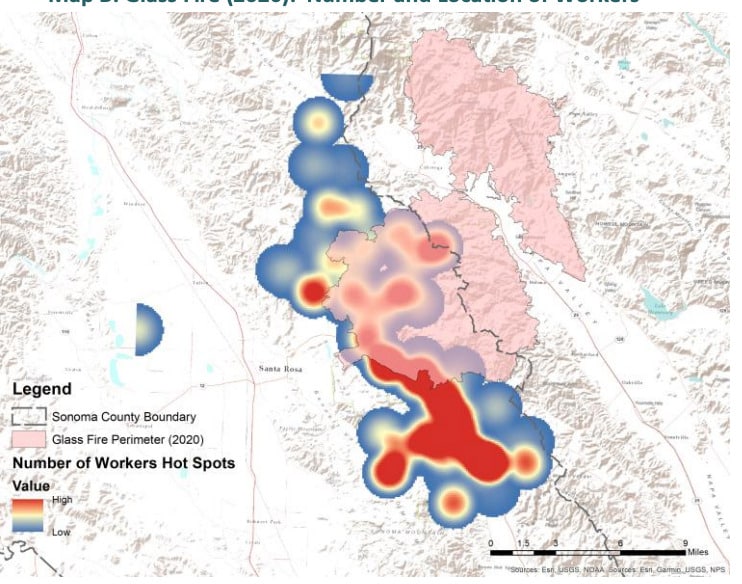
Farm workers are often expected to work in unsafe conditions and without proper safety protections. In 2017, Sonoma County started the interim Agriculture Pass (Ag Pass) program, which gave farm workers passes to vineyards and fields in mandatory wildfire evacuation zones to safeguard and harvest crops. During the Glass Fire, many workers were assigned to work within the fire perimeter (see graphic) where they were exposed to harmful smoke without adequate safety equipment or procedures in case of emergency (Méndez and Pizarro, 2020).
Breathing in wildfire smoke increases inflammation and the risk of lung disease. The smoke from wildfires can contain metal contaminants, chemicals, and higher levels of PM2.5, a small particulate matter that can cause the most damage to the lungs. People working outdoors are already exposed to higher amounts of pollutants but in the event of a wildfire outdoor workers can face disproportionate challenges when they are forced to work in unsafe conditions. Still, when they are unable to work because of disruptions caused by wildfire events, their income is impacted which can make the financial difficulties of responding to wildfire even greater. Wildfires will impact the health or financial well-being of farmworkers, so empowering workers to have more say in the Ag Pass program is essential.
Accounting for Social Factors in Wildfire Risk Analyses
With ample academic research and anecdotal evidence showing the strong connection between social factors and climate resilience, it begs the question of why social factors are so often left out of risk and vulnerability studies. For example, CAL FIRE’s fire hazard severity maps, a widely used resource for assessing the risk of fire danger, only account for environmental factors like vegetation type and density, wind, and slope but leave out key social determinants of risk as well as aspects of the built environment that can greatly impact wildfire risk. In other words, CAL FIRE maps are good at identifying what land and parcels are most exposed to fire risk, but they fail to account for the sensitivity and adaptive capacity of the people living in that place, and thus, are failing to account for the full spectrum of wildfire vulnerability.
“What gets measured gets managed,” goes the famous saying attributed to Peter Drucker. For better or worse, we rely heavily on maps and data in climate adaptation and resilience planning, which can harmfully exclude factors from analyses if they can’t be measured in relation to other data and inputs. While we certainly need more acceptance of qualitative data and a nuanced understanding of “expert knowledge,” we also need resources for understanding how social and economic factors impact risk in relation to spatial wildfire risk data.
The Wildfire Social Vulnerability Index Map Layer (WSVI)
As part of our Bay Area Resilience Hotspots project, we are using spatial data as a first step to identifying high-priority lands for nature-based solutions to bolster the resilience of climate-vulnerable communities. Understanding the importance of social vulnerability factors, we knew data would be a useful tool to speak to the social and economic factors that impact resilience, in addition to the best available climate data and conservation priorities. However, after consulting with technical advisors and digging into available resources, we realized there was no existing data source for understanding the sensitivities and adaptive capacities of Bay Area communities in the context of wildfire.
So, why do we need a Bay Area WSVI?
- There is a need for an Index that is specific to wildfire with research showing that there are unique factors that put populations at greater risk.
- Existing social vulnerability indices often fail to show the vulnerabilities of rural communities adequately.
- Bay Area communities often don’t show up on statewide indices because of relative affluence/conditions, yet, we know that our region has many communities that stand to lose the most if no action is taken in the face of climate change.
Additionally, WSVI will be a shareable resource that can be overlaid with any wildfire exposure data to understand where there are communities that may be especially sensitive to wildfire impacts or may lack the adaptive capacity to recover after a wildfire event. By integrating this index into your analysis, you can more accurately understand wildfire vulnerability and create plans and resources to measurably reduce vulnerability, rather than allow disaster events to exacerbate existing inequalities further.
This index is just one piece of the full Resilience Hotspots project, which will launch in 2023 as a Bay Area-wide effort to better prepare communities for a more resilient future and position the region to contribute to California’s 30×30 goals.
Header photo credit: Mosquito Fire 2022 by CALfire Flickr/CC-BY-NC
This blog is part of a broader series called Bay Area Resilience Hotspots, which seeks to illuminate some of the challenges and opportunities in preparing the region for the climate crisis.